The Thingvellir National Park is a national park in southwest of Iceland. Outside Iceland, the spelling is mostly used Thingvellir used.

| location | ||
| ||

background
Þingvellir was founded in 1928, making it the oldest national park and the most significant historical site in Iceland. It has been a UNESCO World Heritage Site since 2004.
history
The lungingplatz was the nucleus of the medieval state after the settlement of Iceland. In 930 the first Alþing, a parliament-like assembly, was convened here, which met once a year. Up to 4,000 people gathered to settle disputes and pass laws. The 48 Goden (chiefs) had the seat and vote. The meeting lasted until 1798. Then the Danes dissolved the Alþing. The Republic of Iceland was proclaimed here on June 17, 1944 and is again the scene of numerous state celebrations.

Landscape & geology
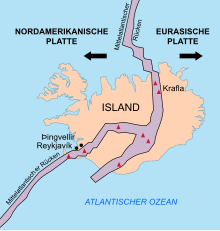
Þingvellir lies in the middle of a rift valley. The boundary between two tectonic plates is called a rift valley. In this case the Eurasian in the east and the American in the west. Here you can see their shift on the surface over the course of centuries. The plates drift apart by approx. 1 cm every year. The valley has been widening since the end of the Ice Age. At the same time, the level drops continuously. This can be seen well in the Almannagjá (Allmann Gorge) and the Hrafnagjá. Öxará flows through the national park and forms a waterfall at the Almannagjá gorge. This was probably created artificially. It served the water supply at Alþing.Der Þingvallavatn is with 83.7 km² the largest lake on the island and 114 m deep at the deepest point. It is surrounded by four active volcanoes.
Flora and fauna
climate
getting there
From Reykjavík on the R 1 north and then on the R 36 east.
Fees / permits
The national park does not cost any entry.
mobility

Tourist Attractions
- Lake Þingvallavatn with beautiful landscape views. In the parking area, several parking spaces with direct lake views or short footpaths to the shore can be approached from the Uferstraße.
- 1 Lookout point at the visitor center with a view of the "large" continental crevice "Almannagjá" (Allmänner Gorge).
- 1 Þingvallar Church, (Þingvallakirkja) with an old meeting place. The landscape is very beautiful at the tributary of the Öxará in the lake Þingvallavatn.
- 2 Öxarárfoss waterfall - The waterfall pours into the great Allmann Gorge. The fall was most likely artificially created to channel the Öxará river directly to the meeting place. This ensured the water supply during the tribal gatherings. The case is about a 1.5 km walk along the fissure from the visitor center. A car can be used to drive up to a 300 m walk along a side street below.

- 3 Silfra column.


 in the Wikidata database") This water-filled crevice between the drifting plates of the earth's crust at Lake Þingvallavatn is fed by the large glacier w: Langjökull and is 62 m deep. A footpath leads to the shore.
This water-filled crevice between the drifting plates of the earth's crust at Lake Þingvallavatn is fed by the large glacier w: Langjökull and is 62 m deep. A footpath leads to the shore.

activities
Migrations between the rock formations at the borders of two tectonic plates.
to buy
- Souvenir sales in the visitor center
kitchen
accommodation

Hotels and hostels
camping
1 Various camping areas around the information center (contact point for campers, reception, etc.). According to Campinginfo, there is another tent area right on the lake (Openstreetmap lists here 2 a camping symbol). Camping information on the national park website.
security
Practical advice
Þingvellir Visitor Center

The first port of call is usually this when coming from Reykjavík 1 Visitor center, which can be found on the northern edge of the continantal fissure. There is a large car park that can be used without parking fees. There is a separate toilet building directly at the parking lot (fee in September 2015: 200 kroner; payable with two 100 kroner pieces at the turnstile, approx. € 1.45 or alternatively by credit card, settlement at home just under € 3).
It is only a few steps from the center to the viewpoint on the column. Of course, there is also the option of descending into the crevice (stepless, but with an 8 to 10% gradient).
The slim visitor center is designed on the inside based on the continental gap. There is a multimedia exhibition with language information also in German. There is also a souvenir sale. Opening times: June to August: 9 am-6pm; September to May 9 a.m. to 5 p.m.
Information center
2 Second, smaller visitor center in the camping area.
trips
literature
Web links
Þingvellir - Official national park website in English