![]() Click here to see the map of the area in full screen.
Click here to see the map of the area in full screen.
_banner.jpg/1800px-Zahle_(Lebanon)_banner.jpg)
| Location | |
 | |
| Fast Data | |
| Capital city | Beirut |
| State | Parliamentary democracy |
| Coin | Lebanese Pound (LBP) |
| Area | 10,452 km2 |
| Population | 4,822,000 (2012 estimate) |
| Language | Arabic |
| Religion | Islam 58%, Christianity 36%, Druze 5% |
| Calling Code | 961 |
| Internet TLD | .lb |
| Time zone | (UTC 2) |
THE Lebanon is her country Middle East. It is the only country in the Middle East that has no desert at all.
At a glance
Appropriate visit period
Languages
In Lebanon, the official language is Arabic. But there are Lebanese who speak French, English, even Greek or Armenian.
Areas

| Beirut |
| Bekaa The valley east of Mount Lebanon |
| Mount Lebanon |
| Northern Lebanon |
| South Lebanon |
Important cities
Beirut. —
Jounieh. - The city is known for its vibrant nightlife.
Bible. - Ruins of the ancient city of Phenicia.
Batron. - A picturesque coastal city inhabited mainly by Maronite Catholics, but also a significant number of Greek Orthodox Christians.
Tripoli. - The largest city in northern Lebanon
Sidon. - The third largest city in Lebanon and a major commercial center already in the second millennium BC.
Cheese. - In 1986 the ruins of the ancient city were declared a World Heritage Site
Zachle. - Capital of the government Bekaa, known as the "Bride of Bekaa".
Baalbek. A city in the Bekaa Valley known as Heliopolis in the years of the Roman Empire. The archeological site near the modern city is a World Heritage Site
Additional tourist destinations
Beit Mary (Beit Mery). - Holiday resort at an altitude of 800 m. Byzantine churches of the fifth century AD are preserved.
Brumana. - Important tourist center a short distance from Beit Mary and with impressive views to Beirut. During the summer, Brumana receives crowds of vacationers.
Maar Kardardbian (Mzaar Kfardebian). - The most important ski resort in the Middle East
Jita Caves (Jeita Grotto). The Jita Caves are formed by an underground river and present fascinating stalactites and stalagmites.
Deir el Kamar. - Picturesque village built at an altitude of 850 meters.
Beitdin (Beit ed-Dine). - The village of Beitenin is famous for the collection of Byzantine mosaics located in the basement of the palace
Natural refuge of Mount Chouf. —
Bsari. - Resort near the famous Cedars of Lebanon.
 View of the town Beit Mary at the foot of Mount Lebanon. |  Entrance to the Jita caves |  Batroun: The church of Agios Stefanos |  Byzantine mosaic in the mansion Beitdin. |
 cedar forest in the Chouf mountains | 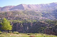 View of the town of Bsari from the Sacred Valley (Wadi Qadisha) | _19.jpg/200px-Baalbek(js)_19.jpg) View of the city of Baalbek |