- This entry is aTravel route。

Karakoram Highway(Also called the China-Pakistan Highway) is the highest paved international highway in the world; it connects Western China and Pakistan. It is one of the few routes to cross the Himalayas, and the most western. Historically, this is a caravan, a branch of the ancient Silk Road. Recently, the Chinese and Pakistani governments built a highway.
The name "Karakorum" comes from the Mongol Empire.
In recent years, this highway has become a destination for adventure activities, and it is ranked third in the ranking of the best adventure destinations in Pakistan. The cross-border point of this highway, the Khunjerab Port has an altitude of more than 4,800 meters (about 16,000 feet), which is the highest paved border crossing in the world. In contrast, the highest peak in Western EuropeMont BlancIs 4810 meters above sea level, the highest peak in the continental United StatesWhitney PeakThe altitude is 4421 meters.
Here may becomeThe ultimate challenge for cyclists. There is an organization of cycling trips, and there are also some books about cycling trips on this road. But in recent years, the amount of travel has declined.
Unfortunately, you cannot cross the boundary line by cyclist, because the boundary line is not open to cyclists. However, you can get on the bus in Taxkorgan or Soest and cross the border by car. On the Pakistani side, you can reach the border by bicycle, but you cannot cross it. At this time, you will need to return to Soest and take the car to cross the border.
learn

This road runs approximately north-south and traverses the entire Karakoram Mountains. This way fromAbbottabadStart, go throughKhyber PakhtunkhwawithGilgit-Baltistan, And then arrive at the boundary line of Khunjerab Port. After entering China, it passed through ChinaXinjiangofKashgar。
The road was built in 1959. It was jointly constructed by the two countries and took 20 years. It was completed in 1979 and opened to the public in 1986. However, more than 800 Pakistani workers and about 200 Chinese workers have traded their lives for the construction of this highway.
This road is also calledChina-Pakistan Friendship Highway. It was built at a high altitude and steep terrain, so it is also calledThe eighth wonder of the world。
history
Wakhan Corridor Wakhan CorridorCan be extended toBaktriaHistorically, it was a smaller trade channel; however, today’s Wakhan Corridor is impassable. The Wakhan Corridor is located in Afghanistan, the terrain is relatively steep, and there is no road or border checkpoint that can legally enter China or Pakistan. |
Prepare
season
In Pakistan, except for the Khunjerab Port, which will be closed due to heavy snow from January to April, the entire section of the road is a two-way all-weather road. In addition, landslides will also block roads, and landslides often occur in some places during the monsoon period (approximately July-September).
Some places are very hot in summer and the temperature can reach 45°C (113°F), such as the area between Besham and Qilas in Pakistan and the desert area in China.
The above shows that in spring and early autumn are the most suitable for traveling here.
Way
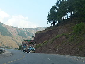
You can choose many ways to travel, for example, by car or biking. However, the best way to travel is to take a convenient and cheap van. Some people say that this is one of the most terrifying roads in the world, because one end of the road is a steep slope with a drop of more than hundreds of meters, and some mountains at the other end look unstable, which makes people feel prone to landslides when the weather is bad. Some sections of the road have become very narrow, and in some places, only one motor vehicle can pass at a time.
If you wish to reach another country via this highway, you need to prepare your visa in advance, otherwise you will not be able to cross the border. In addition, you cannot cross the border on a bicycle, so you can get a bus to cross the border in a nearby town.
arrival

Officials believe that at one end of the road in Punjab, PakistanRawalpindiHassan Abdul, 50 kilometers northeast, and the other end in Xinjiang, ChinaKashgarcity. In Pakistan, it is also called N-35; in China, it is also called G314.
Although the Pakistani end of this road is officially believed to be in Hassan Abdul, it is generally considered that it started atGilgit. However, you can enter this highway in either of these two places. If you wish to enter this highway in Gilgit, you can take a Pakistan International Airlines flight to reach the capital of PakistanIslamabad, And then travel from Islamabad to Gilgit.
If you want to enter this highway from Hassan Abdul, then you can reach Hassan Abdul via the N-5. You can also take an air-conditioned bus from nearby major cities such as Rawalpindi, Peshawar, and Mansera to reach Hassan Abdul, but the cost is relatively high. You can choose to take a cheaper non-air-conditioned bus or van to get here. The time required is generally no more than one hour.
Set off

The following lists the areas that this highway passes through from south to north.
Hassan Abdul
This is a historic town and the starting point of the official road. This is the meeting point of this highway and Grand Trunk Road.
Taxila
TaxilaLocated 20 kilometers east of Hassan Abdul, it is an important archaeological site in South Asia and a world heritage site. There are many places to stay nearby, and there are roads connecting to Haripur.
Haripur
HaripurLocated in Khyber Pakhtunkhwa Province, 30 kilometers north of Hassan Abdul, 40 kilometers north of Taxila. You can get here directly from Hassan Abdul and Taxila. From here, the terrain becomes steep.
Havelian
HavelianLocated 25 kilometers north of Haripur. This was once the starting point of the Karakoram Highway. Havelian is located next to the highway and is served by non-air-conditioned trains. Can be fromKarachiDeparture, take the train through several major cities in Punjab province to arrive here.
Abbottabad
Abbottabad Located in Khyber Pakhtunkhwa province in northern Pakistan.
Mansela
Khan Valley
Bataglan
Besham
Zilas
Gilgit
Naga
Aliabad
Gourme
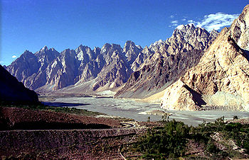
Passo
Suster
Khunjerab
Taxkorgan
Karakul Lake
Kashgar
Safety
In Pakistan, the highway is relatively safe, but the terrain of some sections may be a little dangerous; in general, the more north, the safer it is, especially the section between Gilgit and Khunjerab Pass. If you are worried about safety, you can fly directly from Islamabad to Gilgit or Skardu.