The Alpine path or Alpine climb is one of the highest hiking trails in Black Forest. The mountain hiking path leads through the alpine terrain of the western slopes of the Feldbergs, the highest mountain in Baden-Wuerttemberg. The three and a half kilometer long path was abandoned by the forest administration in order to promote the development of nature there.[1] However, it can still be used as an unmarked route.
Background: location and character


In addition to the rock path above the Feldsee, also on the Feldberg, a path on the Schultiskopf above the Simonswälder Valley, the rock path near Oberried and the connection from the Feldbergpass to the Bernauer Kreuz, the Alpine path on the Feldberg is one of the few hiking trails in the Black Forest that leads through something unusual for the Black Forest , pronounced alpine terrain and thus represents a scenic feature.
Between Hüttenwasen and Stübenwasen, the path runs largely horizontally, with some ups and downs, through the rocky northern slopes of the Feldberg above the Napf, the head of the St. Wilhelmer Valley, below the St. Wilhelmer Hut and the Feldberg Summit. The path bears its name because of the alpine terrain that has to be traversed (rocks, steep ravines), but also because of the alpine vegetation that has one of its last retreats in the Black Forest here, on the north side of the Feldberg, which is remote from the sun and is difficult to access ( the Feldberg area has the status of a nature reserve due to its subalpine vegetation.

Since the way for several years is no longer signposted by the Black Forest Association (but still is still accessible and is sometimes equipped with self-made wooden signs or red markings on a private initiative), the cautious hiker can get to know the alpine terrain away from the tourist streams, but also the effects of the environmental damage of recent years (tree skeletons below Feldberg and Stübenwasen). The condition of the path fluctuates, however: it is blocked in many places by fallen trees, in summer it is usually overgrown and in particular the access (or exit) from Stübenwasen is then hardly to be found for those who are not familiar with it. This is all the more true for the descent to St. Wilhelm, which - hardly recognizable anyway - is often made more difficult in its upper part by fallen or felled trees.


Entrances, course and exits
The following describes the Alpine path in the direction of Hüttenwasen - Stübenwasen. However, each of the exits described can also be selected as an access.
Openstreetmap Relation Alpine Path - Course of the route
Access

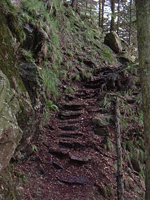
In the northwest of the Feldberg main summit, a saddle that initially slopes steeply and then rises again to the Dead Man stretches between Zastler Loch and St. Wilhelmer Valley, the Hüttenwasen, a high pasture. Below the Hüttenwasenhütte, a small wooden shelter at the lower end of the pasture, the hiking trail crosses a small stream down into the St. Wilhelmer Valley. About 10, 15 meters down the valley branches off to the left 1 Access to the alpine path below the "Hüttenwasenhütte" refuge a small, unmarked path into the forest, the Alpine path. After a few meters you will pass two signs, one that identifies the forest on the north side of the Feldberg as a Bannwald, and a second that indicates the Alpine path (Fig. Above).
Path condition & course

The path (Walking time: around two and a half to 4 hours depending on fitness and tour pace) runs in a clockwise direction (mountain side on the left) around the Napf, about halfway between the Feldberg summit and the valley floor. The terrain requires No fear of heights and surefootedness, Because you tops some rocks, streams and various fallen trees. At a few short key points there is a little climbing dexterity required, in other places the narrow way slipped. In May 2014, a helpful rope with knots was attached to the only "real" 3 m high climbing point. In wet weather, danger of thunderstorms, strong winds, storms or residual snow, we do not recommend walking. Furthermore, there is a constant risk of dead wood breaking off. Due to the fact that as of May 2014 there were around 40 trees lying both across and lengthways, feet and hands are used. Some leg scratches may also be included. The path can usually be found quite clearly. If you do lose the hiking trail, you can usually find the route again quite reliably through the white arrows or green dots sprayed on the trees. The path is an experience, but has to be tackled with the necessary respect. It should only be used in dry, stable weather.
The Alpine path leads through mixed forest, which consists of beeches, mountain ash, sycamore, spruce, silver fir and Douglas fir, with the conifers predominating. The hiker also passes rock faces, avalanche tracks and the forest-free cattle pastures typical of the agricultural use of the Black Forest (on the Hüttenwasen and below the St.-Wilhelmer-Hütte). T. pioneer vegetation can be found. The environmental damage of recent years can also be seen particularly clearly in the numerous tree skeletons below Feldberg summit and Stübenwasen stand. Occasionally one also meets those who are not originally native to the Black Forest Chamoiswhich, of course, are also responsible for the numerous damage caused by browsing young trees, especially silver firs, and the resulting outdated structure of the ban forest.
Exit 1
After about two and a half hours of walking, during which you always have the mountain on your left, the path climbs up to a rocky mountain spur after a somewhat narrower right-hand bend 2 Location rocky mountain spur where the path, represented by hikers and those who take a rest, runs into several tracks that mostly end in the undergrowth. The Alpine path turns sharply to the left, directly on the spur. You continue uphill towards Stübenwasen. About 20 meters up after the left bend, where the path has clearly detached itself from the tangle of footprints, a path branches off at right angles to the right through the high vegetation in summer and through numerous fallen or felled trees, which are now barely recognizable to adapt to the terrain, make a slight left turn and then turn right. After about 100 meters the path becomes clearer and leads safely in several bends over and between rocks down over a scree field that extends down into the bowl. After one last hairpin bend, the scree field is crossed one more time. The path ends here at a wide logging path that you follow downhill. After a few hundred meters, this meets another wood removal path, on which you can descend to the right into St.-Wilhelmer-Tal. However, if you follow this path uphill to the left, you will soon recognize the narrow path on the right that leads to the right in the forest into flatter terrain. There it turns to the left and ends after another right bend on a wood removal path above a farm in the district of Wittenbach.
-> Exit 1 according to description with map status 07-2013 in Openstreetmap not comprehensible (Wittenbach is included in the valley 3 Hoflage Wittenbach)
Exit 2


You go after the left bend on the mountain spur 4 Location rocky mountain spur? between rocks and fallen trees continue straight on instead of turning right as in exit 1. Here the path first leads further uphill (you pass another "Bannwald" sign) and then, after a wide right bend at an acute angle, comes to a busy logging path (at 5 Crossing the roadway). This is crossed directly, the path, which is often heavily overgrown and barely recognizable, continues on the other side to the left in the direction of the forest (in front of the forest there is a sign in the direction from which you are coming, an arrow with the designation "Hüttenwasen "). Well visible again, it leads as a wide path into the forest and after a right and a left bend 6 right / left turn before the Stüberwasen now narrower and further increasing on the Stübenwasen. It ends directly behind the Stübenwasenkreuz 7 End of the alpine path at the Stübenwasenkreuz. A beautiful one opens up at the Stüberwasenkreuz Valley view To the south.
abbreviation
After about two-thirds of the way, coming from Hüttenwasen, the terrain on the left becomes flatter, and near a stream the forest, which is lighter here, offers a view of a pasture (approx 8 Branch to the shortcut to the Stüberwasen saddle - Feldberg around here?. Through a clearly visible passage in the pasture fence you get to a clearly recognizable path over meadows, initially ascending to the right over a stream, then after a short forest turn left and initially steeper out to the saddle between Stübenwasen and Feldberg, which is soon to be recognized, near the St. Wilhelmer Hut and the Todtnauer Hut .
All exits can also be used as entrances.
Connection
The Alpine path can be easily reached from the Stollenbacher Hut (access from the Zastlertal) or the Erlenbacher Hut (access from Oberried) on the Toten Mann over the Hüttenwasen, as well as from the Todtnauer Hut (over the Stübenwasen).
Round trips
- The alpine path can be easily integrated into a trip around the Feldberg: Feldberger Hof - Felsenweg - Baldenweger Hütte - Zastler Hütte - Hüttenwasen - Alpine path - Stübenwasen - Todtnauer Hütte - Feldberger Hof, approx. 6 hours walking time.
- Nice day round tour with Felsenweg and Feldberg summit from Feldberger Hof: Feldberger Hof - Felsenweg - ascent via Emil-Thoma-Weg to the saddle between Seebuck and Feldberg - ascent to the Feldberg summit - descent via the nature trail to the start of the alpine path at Hüttenwasen - walking on the alpine path to Stübenwasen - Return via Todtnauer Hütte on "civilized paths" south past the Seebuck to the Feldberger Hof; Walking time 5½ - 6½ hours depending on speed, condition and (photo) breaks
- A half-day tour is an approx. 14 km long circular hike with start and finish at the parking lot at the "Linde" inn at the end of the road into St. Wilhelmer Tal. In the afternoon there is the ascent of the Alpine Path against Turning clockwise it is worthwhile, as you can enjoy numerous views of the Feldberg summit lying in the light with the sun behind you! (approx. 500 meters in altitude)
Individual evidence
- ↑Ninja Friedel: District of Breisgau-Hochschwarzwald: Feldberg: Alpine path: abandoned by the forestry office - an insider tip for hikers, Badische Zeitung, August 20, 2011,. Retrieved January 21, 2013
- A bit wilder - the Alpine path on the Feldberg - Article in the Badische Zeitung from May 2014