
The route around the four bays that the Bay of Kotor (Boka Kotorska) form leads from Herceg Novi above Kotor to Tivat. Geographically, it is characterized by the fact that steep mountains rise behind the sheltered bay. The opening to the Adriatic between the Croatian Cape Oštra and the Luštica peninsula is only about 1200 meters wide. The water is crystal clear almost everywhere.
background


The ancient Romans already appreciated the protected location for their city of Acruvium. After the fall of Byzantium, the region was fought over: the Venetians, the Serbian Kingdom, the Republic of Ragusa and the Ottoman hordes took turns. Since 1813 the area was part of the Kingdom of Dalmatia, one of the crown lands of the Habsburg monarchy. The official language was Italian. In 1919 Kotor came to the Kingdom of Yugoslavia. During the First World War, it was still called Italian by the Habsburg Monarchy Naval port of Cattaro, where the sailors mutinied in early 1918. Today a plaque in the fortress points to the executed Frantisek Ras (Franz Rasch), Jeroko Sizgoric, Mate Brnicevic and Anton Grubar. In German-language literature, the uprising of February 1918 is particularly marked by drama The sailors from Cattaro of the playwright Friedrich Wolf known.
During World War II, the Italians had a base here. After the betrayal Marshal Bardoglios the Wehrmacht took control for a while, which is documented by the issuance of its own overprinted stamps. Even in the Yugoslav period, especially in socialist Yugoslavia, the bay was an important naval port. In 2002 the last naval base was closed. Since the area has been fortified over and over again for centuries, visitors to the decaying bunkers get their money's worth.
The tourist infrastructure has been expanded since the 1960s. Accommodation from campsites to better hotels can be found in every village. Private room rental companies often have the sign so at home. Theoretically, foreigners who spend the night in private accommodation in Montenegro have to register themselves and, if necessary, pay the tourist tax. There is no control.
Just before the catastrophic 1979 earthquake the "scenic and cultural-historical region of Kotor" became part of the UNESCO World Heritage. It is thanks to this status that a large part of the historical building fabric has been faithfully restored. A 2½% solidarity surcharge, limited to ten years, for the Yugoslav workers and specialists from Japan, who ensured earthquake-proof constructions, helped.
climate

Typically Mediterranean on the coast, but in the hinterland with high amounts of rain. Due to the shielding effect of the steep high mountains of the Orjens and the Lovčen massif rising above the narrow coastal zone, there is also a specifically humid subtype of subtropical vegetation in the climatically favorable area. At the mountain village 1 Crkvice![]()
![]()
![]() the highest value in Europe is measured with an annual rainfall of over 4500 mm.
the highest value in Europe is measured with an annual rainfall of over 4500 mm.

getting there

- Tourist offices
- 2 Turistička organizacija Tivat, Palih Boraca. Tel.: 38232660165. Open: Low season: Mon.-Fri. 7.00 a.m.-3.00 p.m., Sat. 8.00 a.m.-2.00 p.m.
By plane
- Podgorica Airport
- Dubrovnik airport
- 1 Tivat Airport (IATA: TIV).


 in the Wikidata database") Charter airlines take care of 80% of the annual passenger volume from June to September.
Charter airlines take care of 80% of the annual passenger volume from June to September.

In the street
It is more busy Karasovići border crossing on the Landstrasse 8, the Dubrovnik connects with Herceg Novi.
There are three direct buses a day in winter and significantly more in summer from Dubrovnik to Herceg Novi (93 km, 2 hours drive, 2019: just under € 20).
sailing
Pleasure craft that come from abroad have to deal with their paperwork in the 2 Marina Zelenika(42 ° 26 '56 "N.18 ° 34 ′ 21 ″ E), the 3 Port of Kotor(42 ° 25 '34 "N.18 ° 46 ′ 4 ″ E) or in 4 Porto Montenegro(42 ° 26 '11 "N.18 ° 41 ′ 29 ″ E) from Tivat. There are other marinas at the Sailing Club Montenegro in Herceg Novi, 5 Perast(42 ° 23 '36 "N.18 ° 42 ′ 13 ″ E), near Kotor the 6 Marina Glavati Prcanj(42 ° 26 '37 "N.18 ° 45 ′ 12 ″ E) and at Tivat, 7 Marina Solila(42 ° 23 '36 "N.18 ° 42 ′ 13 ″ E). It is on the Adriatic side 8 Luštica Bay Marina.
Coastal route
The route follows the continuous coastal road from the Croatian border in the west along the four bays until you get back to the Adriatic. It is suitable for both drivers and cyclists. The latter should switch from the main road to coastal village roads where appropriate.
There is a possibility of abbreviation at the narrowest point of the Verige-Tight by the car ferry between the villages 9 Kamenari and 10 Leptanes. The ships commute all day, you will never wait longer than 15 minutes in summer; Pedestrians travel free, cars cost € 4.50 in 2021. In winter there is no traffic after 10 p.m.
Topla Bay and the west coast of Tivat Bay

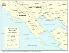
The Adriatic part of the Prevlaka Peninsula is Croatian, even if the exact border line is still controversial. The 3 Kobila border post marks an EU external border. From here you first come to the bathing village 2 Njivice![]()
![]() that is deserted in winter. The approximately 1 km long beach is pebbly with little sand. A nudist zone is designated.
that is deserted in winter. The approximately 1 km long beach is pebbly with little sand. A nudist zone is designated.
(The dominant Hotel Riviera, a package tourist castle from the 1970s, closed permanently. It will still be listed in relevant booking portals at the beginning of 2021. For non-guests, entry to the "beach" was required.)

The 1 Sutorina Beach is for nudists.
- Along the Topla Bay of Herceg Novi to Bijela, a good 13 kilometers of road.

The three parts that make up the center of Herceg Novi form - Igalo, Topla and Nemila - see the own article.
The “blue line”, a local bus, connects Igalo - Zelenika - Baošić - Bijela - Kamenari every half an hour.

There is a marina in Meljine. The pebbly sandy beach is divided into two small halves by a hotel.
Zelenika, which was only founded in 1900, was the southernmost station of the Habsburg monarchy. The beginning of tourism is set with the opening of the "Pension am Grünen Strande" by a Hungarian spa doctor in 1902. The place has clearly seen its best times, but it can still get very crowded in summer. That is in the hinterland 3 Kuti village![]()
![]()
![]() . The ruins of a church from the 10th century still stand here. The museum in Herceg Novi exhibits their preserved art objects. At the Marienkirche are the graves of those who fell in a battle in 1678. Njegoš has it in his work The mountain wreath heroized.
. The ruins of a church from the 10th century still stand here. The museum in Herceg Novi exhibits their preserved art objects. At the Marienkirche are the graves of those who fell in a battle in 1678. Njegoš has it in his work The mountain wreath heroized.
Kamp Šumadija is purely a seaside resort. At Ðenović or Kumbor, the Topla Bay merges into the Tivat Bay. The managed beach of the place is concreted. A high-priced apartment complex was built on the former site of the naval base in 2012-20.[1] in the 3 Mirko Komnenović Local History Museum (8:00 a.m. to 2:00 p.m.) the life of a wealthy family around 1900 is recreated.
The economy 4 Bijelas![]()
![]()
![]() (Бијела) had been dominated by the Adria shipyard there for ninety years since 1927.[2] There is sufficient accommodation. However, the whole section is not blessed with (sandy) beaches, so that you can almost only get into the sea via concrete ramps.
(Бијела) had been dominated by the Adria shipyard there for ninety years since 1927.[2] There is sufficient accommodation. However, the whole section is not blessed with (sandy) beaches, so that you can almost only get into the sea via concrete ramps.

In the hills above you can hike several old churches. The most worth seeing is probably that 4 Church of the Robe of Our Lady (Црква полагања ризе Пресвете Богородице) with frescoes and art objects from the 15th century.
Detour: Cape Oštra

At the tip of the Prevlaka peninsula (Italian: Punta d'Ostro) the old one is still standing 5 Fortress on Cape Oštra on Croatian territory.
Detour: Orjen National Park
Direction of the Orjen National Park (= Parks Dinarides) one bends 5 Morinj![]()
![]()
![]() from the coast to road P11 to 6 Grahovo
from the coast to road P11 to 6 Grahovo![]()
![]() from (27 km). The karst landscape of the park, which was designated in 2018, is worth seeing with a good 8,300 km². The pass height is 1549 m, the limestone walls of the Orjen Mountains rise up to an average of 1000 meters.
from (27 km). The karst landscape of the park, which was designated in 2018, is worth seeing with a good 8,300 km². The pass height is 1549 m, the limestone walls of the Orjen Mountains rise up to an average of 1000 meters.
.jpg/320px-E65,_Morinj,_Montenegro_-_panoramio_-_ines_lukic_(3).jpg)
Snow usually does not stay in the highlands until November and then accumulates until March or April.
Risan Bay


Of Bijela over Risan it's fifteen kilometers, another seven to Perast.
Those who like to hike can go from Risan to the ruins of the 6 Nikolas fortress climb. On a 9.5 km path you overcome an ascent of 580 meters. For this you will be rewarded with grandiose views over the bay.
Only ruins remain of Fort Šanik.
On the banks of the Verige Strait, which is 340 meters wide at its narrowest point, lies Kamenari, in the vicinity of which reddish limestone is extracted that was widely exported (came = Stone). The ferry crosses here. There are mainly private accommodations in the village and in Morinj. Here, too, the beaches are rather pebbly.
In Lipci, where there are prehistoric stone paintings, and in Strp, mainly locals have their quiet holiday homes.
7 Risan![]()
![]()
![]() is the oldest town on the Bay of Kotor, it lies in its farthest corner. The quiet place is a popular tourist destination mainly because of its many beaches. The treasury of the Peter and Paul Church, built in 1601, is worth seeing.
is the oldest town on the Bay of Kotor, it lies in its farthest corner. The quiet place is a popular tourist destination mainly because of its many beaches. The treasury of the Peter and Paul Church, built in 1601, is worth seeing.
Risan is on the Budva - Kotor - Risan bus route Nikšićwhich is operated four times a day.

Bay of Kotor
("Bay of Kotor" refers to all four as well as specifically the part in front of the eponymous city.)


Perast to the city Kotor, 12 kilometers:
8 Perast![]()
![]()
![]()
![]() is a listed building as a whole. You can see two Orthodox and Catholic churches (one ruin) as well as several aristocratic residences from the 17th century in a small space. ("Palaces") two of which have been converted into hotels. The local history museum is in the Bujović palace near the entrance to the village (10 a.m. - 5 p.m.).
is a listed building as a whole. You can see two Orthodox and Catholic churches (one ruin) as well as several aristocratic residences from the 17th century in a small space. ("Palaces") two of which have been converted into hotels. The local history museum is in the Bujović palace near the entrance to the village (10 a.m. - 5 p.m.).

In front of it are two small islands, both with churches on them:
- Sveti Đorđe (St. George's Island), too Sveti Juraj called. A Benedictine abbey was located here, but it continued to deteriorate after the great earthquake in 1667. Only in the last few decades has it been extensively renovated.
- Gospa od Škrpjela 3000 square meters in size, created by artificial embankment over a rock. Was built from 1630-1722. The church was created for an icon of Mary found by sailors in 1452. There are 68 pictures by the painter Tripo Kokolja on the wall and ceiling. Around 2500 votive tablets are on display.
Above 9 Orahovac![]()
![]()
![]() is another St. George's Church.
is another St. George's Church.

Dobrota is already a suburb of Kotor, which is described in its own article.
East side of Tivat Bay

Kotor up Tivat It's only twelve kilometers through the Kotor tunnel and past the airfield. If you follow the coastal road around the peninsula, it is almost 14 km to the tip at Lepetane. From there another eight kilometers.
On the bay are Donja Lastva and Seljanovo, both also districts of Tivat (Ital. Teodo), which is described in its own article. Here is the port too Porto Montenegro. The airfield is in the bend of the bay at the transition to the Luštica peninsula. The Solila protected wetland follows.
From the short sandy beach 2 Kalardovo after 400 meters you cross a small bridge to an offshore "flower island" with two old churches.
The 7 Sveti Marko island (= Školj, Italian: Stradioti) has housed a large holiday complex since 1962, which was later converted into 500 beach huts by Club Med. It was abandoned during the war in Yugoslavia. The island has been unused since then.
It is a good idea to hike through the hills of the peninsula. One comes in the area of the village Bogdašići (Богдашићи) on the summit of Čisti Vrh and the 8 Lake at Vrmac![]() past. The path leads through the oak forest of St. Ilja to the church, which was built in 1410 9 Male Gospe. A steep path from here goes towards the coast near Porto Montenegro (5.5 km, 330 meters in altitude). If you go straight ahead instead, you come to Lepetane (2.6 km, 360 meters in altitude). Much of the agricultural land and groves have been abandoned and the returning wildlife is said to include dormice, marmots and nightingales.
past. The path leads through the oak forest of St. Ilja to the church, which was built in 1410 9 Male Gospe. A steep path from here goes towards the coast near Porto Montenegro (5.5 km, 330 meters in altitude). If you go straight ahead instead, you come to Lepetane (2.6 km, 360 meters in altitude). Much of the agricultural land and groves have been abandoned and the returning wildlife is said to include dormice, marmots and nightingales.
Detour: Lovćen National Park

If you want, you can visit the Lovćen National Park, which is only three kilometers as the crow flies behind Kotor, on foot. However, there are 1670 meters of altitude to overcome on 21 km of serpentine paths. The highest points are Štirovnik (1749 m) and Jezerski Vrh (1657 m). Local patriots consider the mountain to be the symbol of Montenegro. (The summit is not to be confused with that Jezerca (alb. Maja e Jezercës), which is only 5 km across the border on the Albanian side.)
In view of his approaching death, Petar II was destined to be buried here as early as 1851. Three years later a chapel was built for his bones. Before the First World War, the independent Montenegro had built fortifications here with French help, from which the Austrian naval port of Cattaro was shelled until the Austrian campaign which ended in January 1916. Due to the war, Njegoš was reburied in 1916-25 and a new chapel was built. The Njegoš mausoleum, created 1970-74, based on the plans of the Croatian sculptor Ivan Meštrović († 1962), was built on its foundation. From the parking lot at 1578 m you have to climb another 461 steps to the mausoleum.
Luštica Peninsula
The thirteen kilometer long peninsula is 47 km² in size. The coastline on the side facing the bay has hardly any relief.
- South coast of Tivat Bay
Of Tivat to Rose, 25 kilometers.
The remains of the 10 Austro-Hungarian fortress Kabala, above rose. Fort Luštica was a few hundred meters away.
10 Krašići![]()
![]()
![]() (Крашићи) is a seaside resort. Concrete slabs form the beach, the seabed is coarse gravel. The old village of Krašići (Gornji Krašići), was destroyed by the earthquake in 1979, and its population was relocated here in new buildings. The district called "Krašići 2/2" is a settlement built entirely for tourists. In addition to the houses of the approximately 130 permanent residents, there are over 800 for tourists, plus self-built holiday homes.
(Крашићи) is a seaside resort. Concrete slabs form the beach, the seabed is coarse gravel. The old village of Krašići (Gornji Krašići), was destroyed by the earthquake in 1979, and its population was relocated here in new buildings. The district called "Krašići 2/2" is a settlement built entirely for tourists. In addition to the houses of the approximately 130 permanent residents, there are over 800 for tourists, plus self-built holiday homes.

A port already existed in ancient times 11 rose. The village at the tip of the peninsula is hardly inhabited today in winter, many of the houses are used as summer holiday apartments. The old fortress has also been converted into a mid-range hotel. On the lake side there are three concreted tunnels driven into the rock, which were built as bunkers for submarines during the Second World War. You can swim into it. Above the tranquil village there are three small churches from which you have a good view.
- On the Adriatic
Of Rose to Bigovo
Nice beaches are at 3 Žanjice and the one from Arza and Mirište as well as separated by a hill 4 Dobreč.
The 11 blue grotto![]()
![]() (Plava špilja), hidden under a steep cliff, can be visited from the sea. It is about nine meters high and has two entrances. There are corresponding boat tours.
(Plava špilja), hidden under a steep cliff, can be visited from the sea. It is about nine meters high and has two entrances. There are corresponding boat tours.

security
Severe earthquakes such as 1857, 1858 and 1979 repeatedly occur throughout the region.
It is uncomfortable to step on sea urchins.
- Emergency call
- Police: 122, Kotor Police Station: 382 32 322 743
- Fire department: 123
- Emergency doctor: 124
trips
North to Nikšić.
South to the picturesque coastal town Budva.
literature
- Neumann, Hans-Rudolf; Spohr, Edmund; Bosnia-Herzegovina - Croatia - Montenegro: fortificatory excursion report of a study trip from 19.05. until May 26, 2018; Regensburg 2018; Ser .: Contributions to international fortress research; ISBN 9783897838963
- Stoeckl, Marcus; Montenegro: 50 selected hikes in the "Black Mountains;" Oberhaching ² 2014
- Zsupanek, Norbert; K. u. K. Fortifications, military structures and installations in the Cattaro area (Kotor); Graz 2009; ISBN 9783853331668
- Dramatizations of the sailors' uprising
- Frei, Bruno [1897-1988]; The red sailors of Cattaro: an episode from the revolutionary year 1918; Orig .: Vienna 1927 (publisher of the Wiener Volksbuchh.), Berlin 1963
- Wolf, Friedrich [1888-1953]; The sailors of Cattaro: piece in 6 scenes; Orig .: Berlin 1930 (Internat. Arbeiter-Verl.); 1964 (Reclam)
Remarks
- ↑One & Only, announced opening 2021-03-21.
- ↑The company went bankrupt and its bankruptcy assets were auctioned off in spring 2020. It is not foreseeable at the beginning of 2020 whether the site will be used for tourism purposes. At least the remediation of the soil contaminated with oil and chemicals began in the summer of 2020.