The Cariboo-Central Coast is a sparsely populated region in the central interior and coast of British Columbia, with beautiful scenery, endless outdoor opportunities, and a fascinating gold rush history.
Cities

Cariboo
- 1 Williams Lake – Gateway to the Chilcotin and Central Coast, and centre of ranching and recreational plateau country.
- 2 100 Mile House – Amazing camping opportunities, great nature and beautiful ranches.
- 3 Quesnel – Historic city on the Fraser River dating from the Cariboo Gold Rush.
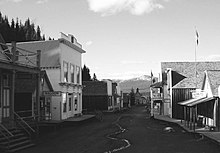
- 4 Wells-Barkerville – Neighbouring historic gold rush boom towns turned ghost towns from the Cariboo Gold Rush with Barkerville being restored and designated a National Historic Site.
Central Coast
- 5 Bella Bella – The main Heiltsuk Indigenous community within Heiltsuk traditional territory.
- 6 Bella Coola
 – A centre for heliskiing.
Other destinations
.jpg/220px-Western_moose_in_the_Bowron_Slough_(DSCF4301).jpg)
- 1 Bowron Lakes Provincial Park - famous for its canoe and portage circle route.
- 2 Horsefly Lake Provincial Park - Great camping, fishing and hiking lake.Beautiful clear water.
- 3 Ts'il?os Provincial Park - remote park with a stunning blue lake framed by mountains.
- 4 Tweedsmuir Provincial Park - British Columbia's largest park is thousands of square kilometres of untouched mountains and lakes.
Understand
The name of the region is a reference to the caribou (reindeer) that were once abundant in the region. The Cariboo was the first region of the Interior north of the lower Fraser and its canyon to be settled by non-Indigenous people. It played an important part in the early history of the colony and province. There are several gold-bearing creeks near the head of the Willow River. The richest of them all, Williams Creek, was the location of Barkerville, which was the focus of the Cariboo Gold Rush and the centre of government for decades afterwards. It is now a museum town.
The Cariboo goldfields are sparsely populated today but they were once the most settled and most powerful of the regions of the province's Interior. Settlement spread southwards of this area, flanking the route of the Cariboo Road and spreading out through the rolling plateaus and benchlands of the Cariboo Plateau and lands adjoining it along the Fraser and Thompson.
This area was made famous by the 1858 Fraser Canyon gold rush, news of which spread as far as San Francisco, bringing over 30,000 hopefuls to the essentially uninhabited area. Three more lesser gold rushes brought prospectors even farther north, and gave birth to many of the communities there are today.
Talk
English is the language of this land.
Get in and around
By car
From Vancouver, Highway 99 runs north and connects to Highway 97, which is the main road in to, out of and through the region. From Calgary, the Trans-Canada Highway (#1) through Kamloops to Cache Creek, where it meets Highway 97.
By bus
Adventure Charters operates several buses a week from Surrey (a suburb of Vancouver), Hope, Prince George and Kamloops to 100 Mile House, Quesnel, and Williams Lake.
By plane
The Williams Lake Airport has daily flights from Vancouver.
Quesnel Airport has daily flights from Vancouver.
See
History buffs should take a look at the 108 Mile Ranch Heritage Site, near 100 Mile House (okay, it's 8 miles from there). There is a collection of pioneer-era buildings, and a museum that is open in summer. The Quesnel & District Museum & Archives tells the stories of the residents of early 20th-century Quesnel, including the Chinese, the Sikhs, and First Nations people. The big historical site, though, is Barkerville, a ghost town 80 km (50 miles) east of Quesnel. The gold rush boomtown of 5000 people is now preserved as a National Historic Site.
Quesnel also offers the longest wood truss walking bridge in the world, and fire hydrants turned into historical figures.
Do
.jpg/220px-Hiking_Bella_Coola_(3686595776).jpg)
The outdoor adventures of this area are limited only by your imagination. Unlimited hiking and biking trails for any ability, camping in sites untouched by other humans, and canoe and portage tours through remote lakes are just the beginning. Spend a few days of adventure in the wilds at one of the regions many guest ranches - roam the open range on horseback, cast to a rising trout in back country waters and watch bears in their natural habitat.
Cross-country skiing is particularly popular around 100 Mile House, which is the home of the largest cross-country skiing in the world (over 10 m long).
The Williams Lake Stampede on the Canada Day (July 1) weekend attracts top professional cowboys for bull riding, barrel racing, bareback riding, tie-down roping, steer wrestling, team roping and chuckwagon races.
- Ts'yl-os Park Lodge (north end of Chilko Lake, gateway to Ts'yl-os Provincial Park), toll-free: 1-800-487-9567. Take a one hour flight from Vancouver to remote Tsylos Park Lodge to experience excellent fly fishing, horseback riding, hiking and hunting. Sixteen guests are accommodated in four individual guest rooms and three cabins, all with private bathrooms.
Stay safe
Go next
Keep heading north on Highway 97 to Prince George and on to Yukon.
Or head to Vancouver through the BC Interior, or Calgary though the Canadian Rockies.