Cumbernauld is a town on Clydeside in central Scotland, 13 miles northeast of Glasgow, with a population of 52,000. The name is Gaelic, comar nan allt meaning the meeting of waters, and it's near the watershed of the Clyde and Forth river catchments. It grew up as a weaving centre in the 19th century as the railway arrived, then expanded rapidly from 1955 when it was designated a "New Town".
This was the third of five such towns built to alleviate Scotland's housing shortage, preceded by East Kilbride and Glenrothes, and followed by Livingston and Irvine; the intended sixth at Stonehouse was never built. Cumbernauld shares their drab brutalist architecture, and was especially influenced by the 1963 Buchanan Report "Traffic in Towns." In many ways this report was far-sighted, but implementation was shoddy, and 1960s politicians were in thrall to the car. The town's vertical segregation of pedestrians and vehicles meant few pedestrian crossings but many bridges, flyovers and underpasses, which became linear lavatories for the town drunks, and the place was mocked as "Noddytown". It might have overcome this with other attractions, but these are frankly lacking, and most visitors are just stopping over at the M80 hotels. However the town does lie close to attractive countryside along the canal and up in the Campsie Fells.
Gregory's Girl Cumbernauld is the setting for the 1981 Bill Forsyth film Gregory's Girl. The gawky teenage Gregory is as inept in love as he is in football, and the girl he pines for is a better footballer, replacing him on the team as a forward. In the final scenes he and his pals set off to hitchhike to Caracas, which they can't even spell, but believe that women there greatly outnumber the men. And it's as far away from Cumbernauld as they can imagine. |
Get in
By plane: see below for the direct bus X24 from Glasgow Airport (GLA IATA) to Cumbernauld and St Andrews. It may be quicker to take Bus 500 into city centre and change.Cumbernauld Airport only has private aviation.
Trains run from Glasgow Queen Street every 30 mins, taking 30 mins via Stepps and Greenfaulds, and continuing east via Falkirk Grahamston, Polmont and Linlithgow to Edinburgh, 50 mins.
Trains also run from Glasgow Central every 30 mins, taking an hour to orbit the southern burbs via Rutherglen, Hamilton, Motherwell, Coatbridge and Greenfaulds. Coming up from London, the Midlands and Northwest England, change for this train at Motherwell.
For Stirling, Perth, Dundee, Aberdeen and the Highlands, change at Falkirk Grahamston, or pick up the Stirling train at Croy.
1 Cumbernauld railway station is off S Carbrain Street on the east edge of town, with Greenfaulds station a mile further southwest.
2 Croy is on B802 a couple of miles northwest of town, with frequent trains between Glasgow Queen Street, Stirling and Edinburgh.
Buses: Stagecoach Bus X25 / 25A runs from Glasgow Buchanan station (every 15 mins M-Sat and every 30 mins Sun) via Glasgow Royal Infirmary and Greenfaulds to Cumbernauld town centre, taking 25 mins, and continuing into the eastern burbs of South Carbrain and Abronhill. Some of these buses start from Glasgow University. Bus X28 runs from Glasgow (every 30 mins M-Sa, every couple of hours Sunday) via Mollinsburn, Condorrat and Greenfaulds, taking 35 min.
First Glasgow Bus X3 runs to Cumbernauld every 30 mins daily via Muirhead, Moodiesburn and Greenfaulds, taking an hour.
First Scotland East Bus X37 runs hourly daily from Glasgow to Cumbernauld on a similar route to X3, then continues via Bonnybridge to Falkirk.
First Scotland East Bus X36 runs hourly daily from Glasgow to Cumbernauld then continues via Bonnybridge and Denny to Stirling. But don't get on the X36 operated by Stagecoach West Scotland, or you'll end up in Ardrossan.
Stagecoach Fife Bus X27 runs from Glasgow (M-Sat every 30 min, Sun hourly) via Cumbernauld to Dunfermline, Halbeath Interchange, Kirkcaldy and Leven.
Bus X24 runs hourly daily from Glasgow Airport via Buchanan station and Cumbernauld to Dunfermline, Halbeath Interchange, Glenrothes and St Andrews.
Canavan Travel Bus 43 shuttles M-Sat every 15 mins between Cumbernauld, Croy railway station and Kilsyth.
By road: by car, most approaches are along M80 which passes northwest of town. By bike or on foot you might follow the canal towpath.
Get around

You can walk or take the buses which circle the town, to little point as there's nothing to see. But with your own wheels - and a bike will do nicely - you can quickly escape into nearby countryside, eg north to the canal towpath and Campsie Fells.
See
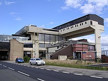
- 1 Cumbernauld town centre, but only if you're curious to see post-war New Town architecture, all drab plazas and shopping centres and brutalist concrete slabs.
- 2 Cumbernauld House Park, a mile northeast of town, has open and wooded areas for strolling. It's ranged around 18th century Cumbernauld House, which is nowadays private apartments, and continues into a bosky glen.
- 3 Palacerigg Country Park has a petting farm, wildlife areas, woodland and open heath. It's two miles east of town next to the golf course, and open daily 09:00-17:00, free.
Do
- Watch football (ie soccer) at 1 Clyde FC. They were promoted in 2019 and now play in League One, the third tier of Scottish football. Their home ground, capacity 8000, is Broadwood in Cumbernauld, a mile north of M80 junction 4A.


- Minor teams Cumbernauld United play soccer at Guy's Meadow, and Cumbernauld RFC play rugby union at Condorrat.
- Palacerigg Golf Course (see park, above) is 5972 yards, par 71 / 72.
- Fannyside Loch just east of the golf course has sailing and windsurfing, but the footpaths are in poor condition.
Buy
- The main shopping centre is along the snappily named "Central Way", with ASDA 200 yards north open daily 06:00-00:00.
Eat
- Town centre eating places include La Bella (daily 12:00-22:00), Beefeater Dovecote (daily 07:00-23:00) and the usual fast-food chains & takeaways.
- There's a Little Asia huddled around the railway station.
- The Village, the historic core before the New Town grew up further south, has Coorie In @ The Black Bull (daily 11:30-00:00) and Invitation[dead link] Indian & Nepalese (Su Tu-Th 16:00-22:00, F Sa 16:00-23:00).
Drink
- 1 The Carrick Stone, 52 Teviot Walk, G67 1NG, ☏ 44 1236 850260. Su-Th 08:00-23:00, F Sa 08:00-00:00. JD Wetherspoon's pub with real ales, and food until 22:00.
Sleep
- 1 Premier Inn Glasgow Cumbernauld, 4 S Muirhead Rd, G67 1AX, ☏ 44 871 527 8424. Decent budget chain hotel near town centre. B&B double £70.
- 2 Travelodge Glasgow Cumbernauld, Auchenkilns Park, G68 9AW (B8048 at jcn 5 of M80), ☏ 44 871 559 1822. Basic budget hotel for a stopover, right by motorway. B&B double £65.
- 3 Double Tree by Hilton Westerwood, 1 St Andrews Drive G68 0EW (Eastfield Rd at jcn 6 of M80), ☏ 44 1236 457171. Reliable mid-range hotel next to motorway. B&B double £100.
Go next
- Glasgow and Edinburgh are within an hour and both deserve an extended stay.
- Stirling is a miniature Edinburgh, and has routes into the Highlands.
- The Roman Antonine Wall runs a few miles to the north through Kilsyth, with the Campsie Fells beyond.
- To discover if they made a better job of Scotland's other four New Towns, see East Kilbride, Glenrothes, Livingston and Irvine. But to be fair to the planners, also go see what unplanned expansion looks like, eg in Dumbarton.
| Routes through Cumbernauld |
| merges with | N | → Coatbridge → The SOUTH (avoiding Glasgow) |
| Stirling ← Falkirk (via | NE | → Kirkintilloch → Glasgow |