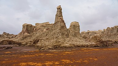
 Acid pools and deposits of salt, sulfur and other minerals in Dallol | ||
| Danakil Depression | ||
| no tourist info on Wikidata: | ||
| ||
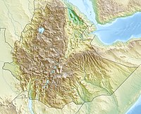
The Danakil Depression, also Dallol valley called, is a desert area in the Afar region in the Northeast Ethiopia north of the Great Rift Valley.
On the one hand, this depression is the hottest region on earth, all year round, and one of the most geologically active.
background

The valley is the home of "Ardi" (Ardipithecus ramidus) and "Lucy" (Australopithecus afarensis) - Hominids who are believed to be our first presumed ancestors. In June 2010, the oldest direct evidence of stone tool making, attributed to the Australopithecus afarensis hominids more than three million years ago, was found in this region.
Near the southern end of the Red sea an immense, more or less triangular plain falls far below sea level: some places near the ghost town of Dallol are almost 120 meters below sea level. The northern part, known as the Danakil / Dallol Depression, is extremely hot and dry and an extension of the Great African Rift Valley. In this apparently inhospitable area live the nomadic Afar, who number around 3 million people and the international legal borders between Ethiopia, Eritrea, Djibouti and Somaliland largely disregarded.
The entire Afar Depression is a geological peculiarity because three active rift valleys meet here and separate the tectonic plates. This is where the extensive submarine ridges that formed the Red Sea and the Gulf of Aden meet, come to the surface and meet the East African Rift. The Afar Depression is one of two places on earth where a Mid-ocean ridge can be examined on land. The other is in Iceland. Currently, the Afar is slowly being pulled apart at a rate of 1-2 cm per year. The bottom of the Afar Depression consists mainly of basaltic lava. The Afar Depression and the meeting of the three fractures also mark the location of one Mantle plume, a large upflow of hot molten rock material from the deeper mantle of the earth that solidifies on the surface to form basalt.
This place, which used to be part of the Red Sea, has salt deposits stretching for kilometers. In some places the salt deposits are about 5 kilometers thick. Underneath many salt lakes there are considerable heat sources of volcanic origin that cause hot water to rise through layers of salt and deposit anhydrite. Minerals also dissolve and are deposited near the sources. They form shapes on basaltic lava flows that are strong Hornito cone remember, but are smaller than these. Sulfur, other minerals and possibly Thermopylae bacteria create a spectacular play of colors.
The depression forms a vast, scorching desert with lava flows, salt marshes and lakes that lie below sea level. Active and extinct volcanoes lie along a south-north axis with the extremely salty Afrera Lake 120 meters below sea level, which is kept alive by the many thermal springs that feed it.
Dallol offers the opportunity to see the first signs of new ocean basin formation. The only volcanic crater below sea level on land, the Dallol volcano has remained inactive since 1926, and will one day be occupied by an ocean basin that joins the Gulf of Aden as the sea floor gradually expands.
To the south of Dallol, rectangular plates of salt are broken up and transported into the highlands by camel caravans in an almost endless procession. The salt gorges south of the Dallol Mountains are among the most impressive geological features of the region. It looks like a different planet because there are many colorful rocks on every meter of terrain. It is reminiscent of images from a science fiction novel in a whitish way.
In summary, the Danakil not only fascinates geologists with its strange lunar landscape full of active volcanoes, with its foul-smelling sulfur-baked hot springs, with frozen flowing black lava and huge salt-encrusted pools. The geological activity of Danakil can be seen from the fact that more than 30 volcanoes, active or dormant, make up about a quarter of all volcanoes studied in the Smithsonian Global Volcanism Program. These volcanoes are all recent. They formed over the past million years, and many of them took their present form over the past 10,000 years.
getting there
The two main access points to the danakil are:
- 1 Berahile


 in the Wikidata database") - about 120 km or 2 hours from 2 Mekele
- about 120 km or 2 hours from 2 Mekele away on the traditional salt caravan route to Lake Asale. Some people have estimated that a million camels passed this route in 2007! This is still at an altitude of around 1000 m and so the heat is not yet oppressive, although it is in a valley between some very dry looking peaks. Carefully built Tigra houses and clean streets mix with the more rudimentary Afar huts. This is the last place for a cold drink in quite a while. You can even have a beer at the bars that mainly feed the military on the dusty descent into town.
 - 3 Serdo - a godforsaken town on the newly paved Assab Road, about 3 hours by car from Afrera Lake. This more southerly route used to be a lot less popular, but the smoother tarmac has changed that drastically.
.jpg/320px-Ethiopie-Berhale_(9).jpg)

One can even consider a round that is in Mekele begins and leads via Berahile, Hamed Ela, Dallol, Lake Asale, Erta Ale and Lake Afrera and returns via Serdo. In this direction the need for a fight with the Afar Tourist Commission would be in Semera Avoided about 50 km before Serdo when traveling from Addis Ababa It takes around $ 80 a day to have three or four armed afaris (depending on your haggling skills and how rich you look) to escort you both ways. In theory, these people should be self-sufficient, but it is probably advisable to take this into account as part of the initial negotiation. If they have relatives on the way it can be cheaper because they can rely on clan loyalty and hospitality - it can also be more expensive if some beg for a ride for clinical treatment, etc.
mobility
There is no local or long-distance public transport.
There are few roads on which cars can be used. Otherwise, one is dependent on all-terrain vehicles or pack animals such as camels, and more rarely donkeys.
Tourist Attractions
The following sights are listed from north to south:
- 1 Dallol.The Dallol region and the lake of the same name are located at the northernmost end of the Great Rift Valley - the largest geographical area in Africa, if you ignore the Erg and Reg of the Sahara, and which is so large that it is used by American astronauts on the Moon was easy to see from there. Because Dallol is below sea level, it seems to trap all the heat. The youngest of its craters, Dallol, was formed during an outbreak in 1926. In the Dallol area there are colorful hot brine springs and deposits in the area of Fumarolessome of which are more than 116 meters below sea level. There are fields of hot yellow sulfur between the sparkling white salt beds. Heat isn't the only thing people feel with Dallol depression. Alarming earthquakes can often be felt. There are also several active volcanoes.(14 ° 14 '30 "N.40 ° 18 ′ 0 ″ E)
- 2 Dallol ghost town.The workers' settlement, built from blocks of salt, is located east of the Tigray highlands and extends over the Eritrean border, is officially the hottest place on earth with an average annual temperature of 35 degrees Celsius and the hottest daytime temperatures of over 40 ° C all year round. Much of this vast and practically uninhabited region lies beneath the driest and most tectonically active areas on earth. The settlement was created in 1918 by an Italian company. The potash salt mined nearby was transported by industrial train to a Red Sea port in what is now Eritrea. After the Second World War, the production was stopped and the railway line was added.(14 ° 14 ′ 20 ″ N.40 ° 17 ′ 38 ″ E)
- 3 Salt gorges. The up to 40 meter high gorges on the southwestern edge of Dallol are the result of erosion processes and may remind you of old ruins from afar.(14 ° 13 '44 "N.40 ° 17 '24 "E)


Spectacular colors in Dallol
Salt hoses

Gaet’ale


- 4 Gaet’ale.Small salt lake that was created in January 2005 after an earthquake[1] with a salt content of 43%, the highest in the world,[2] which is four kilometers south of the Dallol crater. Its water temperature is 50 to 55 ° C. Rising gases, probably volcanically formed carbon dioxide, make the lake boil on the surface. It gets its characteristic yellow color from iron (Fe3 ) Ions.(14 ° 12 '48 "N.40 ° 19 ′ 17 ″ E)
- 5 Asale lake (Karum lake).The approximately 50 square kilometer lake, 116 meters below sea level, is one of the three large salt lakes in the Dakalil Depression and mining area for rock salt. The salt mining, which has been practiced for centuries, is then the main reason for a visit. The salt plates are dismantled by hand, cut into suitable pieces on site, loaded onto camels and brought to Hamed Ela at night, from where they are brought to Mekele be transported further.(14 ° 1 ′ 0 ″ N.40 ° 25 ′ 0 ″ E)


Salt pan on Lake Asale

Asale lake salt production
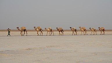
Camel caravan for the removal of the salt plates


- 6 Bakili lake.The lake, located southeast of Lake Asale, covers an area of 40 square meters.(13 ° 56 ′ 0 ″ N.40 ° 29 ′ 0 ″ E)
- 7 Erta Ale (also Ertale or Irta'ale).The active shield volcano, translated as "smoking mountain", is another impressive natural phenomenon. It is the most active volcano in Ethiopia and the only sub-sea-level land volcano in the world. Erta Ale is 613 meters high and has a lava lake in its crater on the summit, one of only five in the world. It is the longest existing lava lake since 1906. Erta Ale, has tech-colored landscapes and incredible mineral deposits. Sulfur lakes and bubbling sulfur springs are fascinating sights not to be missed. Hike at night with your guides and armed guards when it's not that hot, see the lava lake in the dark, then sleep for a few hours on the summit before going back down before the day temperatures get too high.(13 ° 36 ′ 0 ″ N.40 ° 40 ′ 12 ″ E)


Erta Ale
.jpg/338px-Erta_Ale_(6900576021).jpg)
Lava lake in the crater of Erta Ale
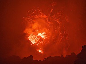
Lava lake during the 2018 eruption

.jpg/338px-Erta_Ale_(6900576021).jpg)

- 8 Afrera lake (Afdera lake).The 100 square kilometer salt lake next to the volcano of the same name is 102 meters below sea level and is up to 160 meters deep. Salt is also extracted from this lake by evaporating water.(13 ° 17 ′ 0 ″ N.40 ° 55 ′ 0 ″ E)

shop
In the settlements there are small retail shops with everyday goods. This includes drinking water and soft drinks.
kitchen
Food can be prepared in the Dallol and Ertale base camps. In the villages there are stalls selling traditional Ethiopian food such as injera, noodles, rice, steamed vegetables, roasted goat meat and others. to offer.
accommodation
Hotels are only available in Mekele.
In the Dallol and Ertale base camps there are simple beds or mattresses and sleeping bags on which you can spend the night in the open air. There are also small guest houses with mattresses and shared bathrooms in the villages in Danakil.
climate
| Danakil Depression | Jan | Feb | March | Apr | May | Jun | Jul | Aug | Sep | Oct | Nov | Dec | ||
|---|---|---|---|---|---|---|---|---|---|---|---|---|---|---|
| Mean highest air temperature in ° C | 36 | 36 | 39 | 41 | 44 | 47 | 46 | 45 | 43 | 42 | 39 | 37 | O | 41.3 |
| Mean lowest air temperature in ° C | 25 | 25 | 26 | 27 | 28 | 30 | 32 | 31 | 32 | 30 | 27 | 26 | O | 28.3 |
security
In several countries, government agencies, including the German Foreign Office, advise against traveling to the Danakil Depression. Travel should always be accompanied by Ethiopian security forces. The Foreign Office explains that "when driving into the direct border area to Eritrea and into the Danakil Depression in North Afar ... violent attacks by bandits and local underground organizations as well as kidnappings cannot be ruled out."
In 2012, a group of tourists was attacked, killing five European tourists, including two Germans, and kidnapping two more.[3] In December 2017, a German tourist was shot dead and an Ethiopian guide injured in Erta Ale.[4] So if you decide to tour this area, consider the current conditions and take careful, strict precautions. It is especially important not to stray too far from the rest of your tour group.
There are also security concerns unrelated to threats of violence. There are no warning signs or fences, but you should stay at least three feet from the edge of the Erta Ale crater. Do not touch the water in Dallol ponds as it is acidic. And in case you should injure yourself, the nearest hospital is in Mekelewhich is several hours away and accessible via Berhale.
People in this region have always had a bad reputation for being hostile rather than welcoming outsiders. Your fearsome curved knife that Jile , was used to castrate rare visitors until the 1930s.
trips
- Berahile is the only significant settlement in the Danakil area with only one mosque.
- 4 Abal is a small town on the border between Tigray and Afar with a mosque and a church.
- Mekele is the next largest city and capital of the Tigray region. The former residence of Emperor Johannis IV is located here.
- 5 Semera is the capital of the Afar region.


Individual evidence
- ↑: Gaet’ale - a reactivated thermal spring and potential tourist hazard in the Asale salt flats, Danakil Depression, Ethiopia. In:Journal of Applied Volcanology, Vol.5,1 (2016), doi:10.1186 / s13617-015-0042-x.
- ↑: Chemical Analysis of Gaet'ale, a Hypersaline Pond in Danakil Depression (Ethiopia): New Record for the Most Saline Water Body on Earth. In:Aquatic Geochemistry, Vol.23,2 (Apr 2017), Pp. 109–117, doi:10.1007 / s10498-017-9312-z.
- ↑: Attack in Ethiopia: Two Germans among dead tourists. In:Mirror online, Wednesday January 18, 2012, accessed on June 21, 2020.
- ↑: Raid in Ethiopia: German tourist killed. In:Mirror online, Tuesday 5th December 2017, accessed on June 21, 2020.