 | ||
| EMalahleni | ||
| province | Mpumalanga | |
|---|---|---|
| Residents | unknown | |
| no value for residents on Wikidata: | ||
| height | unknown | |
| no value for height on Wikidata: | ||
| no tourist info on Wikidata: | ||
| location | ||
| ||
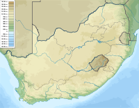
eMalahleni is a town in the municipality of the same name in Nkangala District in the region Mpumalanga.

Map of EMalahleni
background
The town eMalahleni was founded in 1890 and was called until 2006 Witbank. Your new name means coal both in the language of the Zulu and the Ndebele. The city is the administrative seat of a larger municipality of the same name. The former Witbank has around 320,000 inhabitants, the total community comes to over 400,000.
getting there
By plane
By train
In the street
- Of Pretoria it is 110 km on the N4
- Of Johannesburg are there on the N12 about 130 km
mobility
Tourist Attractions
In the vicinity of the city there are over 20 coal mines as well as the associated processing industry, the economic importance of the city is in the foreground. Are of tourist interest:
- Witbank Dam. A large reservoir for irrigation, which also allows numerous water sports.
- Witbank Nature Reserve. In the nature reserve between the reservoir and the N4 there are zebras, springboks, eland antelopes and a diverse range of birds.