| El Chaltén | ||
 | ||
Coat of arms and flag | ||
| State | Argentina | |
|---|---|---|
| Region | Argentine Patagonia | |
| Altitude | 450 m a.s.l. | |
| Inhabitants | 950 (2001) | |
| Prefix tel | 54 2962 | |
| POSTAL CODE | Z9304 | |
| Time zone | UTC-3 | |
Position
| ||
| Tourism site | ||
| Institutional website | ||

El Chaltén is a city ofArgentina.
| ATTENTION: Some of the contents shown could generate dangerous situations or damage. The information is for illustrative purposes only, not exhortative or didactic. Use of Wikivoyage is at your own risk: read the warnings. | |
To know
In the far north of the Los Glaciares National Park in Patagonia, at the foot of the granite masses of Fitz Roy (3,405 m) and Cerro Torre (3,128 m), is located in El Chaltén, the youngest village of the Argentine nation, founded since 12 October 1985. The Fitz Roy and Torre are among the most difficult climbs in the world. The first success on Monte Fitz Roy took place February 2, 1952 by the French Lionel Terray and Guido Magnone, while that of Monte Torre was made in 1959 by Cesare Maestri and Egger Tony.
Note that the ascension period is very limited as it runs from mid-February to mid-March. In these mountains and forests, you can enjoy unique and local creatures, from the pudu, the smallest deer in the world that lives in the forest, and the southern huemul, a species of large deer that crosses the woods. You will also be able to observe and admire unusual birds, such as the magnificent condor and many species of parrots and woodpeckers that live in the southernmost regions of the world. Cerro Torre is a rocket in the shape of Babel, with the top covered with clouds for 300 days a year, crowned by monstrous petals of ice. Not very high, 3,128 meters, but mineral embodiment of the impossible. The most beautiful, the hardest, the most tapered peak ... inspired the most beautiful lie in the history of mountaineering.
Background
The place was founded in 1985 in order to strategically promote a settlement near the border areas between Chile and Argentina. The border conflict is still unresolved, but it has essentially been resolved. In the early years, the small village survives a dark existence in its isolation. With the increase of tourism in Patagonia and the strengthening of the trekking movement, the tourist importance has grown, between 2001 and 2010 the population has grown from a few hundred to 338%, while the limit of 2000 has been exceeded. The construction boom continues today.
How to orient yourself
How to get

By plane
El Chaltén has only a small airport a few kilometers from the village entrance. The nearest airport with regular flight connections, for example to Buenos Aires, is located about 200 kilometers a El Calafate. There are bus connections to and from Chaltén several times a day.
By car
El Chaltén is located about 90 km from Ruta 40. Directly at the entrance to the village is the village's only petrol station (YPF just before the village entrance, in January 2017 it was more of a makeshift petrol station from the container , but open every day from 9:00 to 22:00 in season and from 12:00 to 20:00 in low season April / September, May / August 12-19, June / July 12-18).
Anyone planning visits to nearby towns or along the RN 40 should fill up here. We are about 200km from El Calafate, no gas station in between. If you are coming from the north (Perito Moreno) or are on your way there, you must pay particular attention to a sufficient tank of fuel, as the last gas station of Tres Lagos (120km) and often runs out of fuel. The next petrol station on the RN 40 is only 200km away Gobernador Gregores. When it comes to fuel consumption, it must also be taken into account that all-wheel drive, dirt roads and the wind in the Patagonian steppe have a negative effect on fuel consumption and that not all petrol stations always have enough fuel!
By bus
- 2 hours by bus from El Calafate (south) with around 3 or 4 buses a day, cost around 50-90 pesos (November 2011)
- Approximately 25 hours from Bariloche with Ruta 40. A bus every 3 days. 600 pesos approximately (November 2011)
How to get around
The place can be easily explored on foot. There are trails almost everywhere and the traffic is very quiet due to the 25km / h speed limit.
The main roads of the village are asphalted, most of the secondary roads are still unpaved.
What see

The attraction of El Chaltén is the nature in the surrounding Los Glaciares National Park, where the city is also located, and in the Provincial Reserve Lago del Desierto 40 km away.
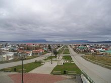
From Mirador al Chaltén, a car park at RP 23 just before entering the city, you have a beautiful view of El Chaltén and the mountain range with the dominating peaks of Cerro Fitz Roy and Cerro Torre.
The new town dates back 30 years and has no buildings to see in a tourist sense.
Events and parties
What to do
The most popular are trekking and hiking in the Los Glaciares National Park around the place. There are a number of fixed routes of varying degrees of difficulty available, and there are also several small free mountain camping opportunities that invite you to take multi-day hikes.
The nearby Southern Patagonian ice field is also ideal for expedition tours such as circumnavigation of the Fitz Roy massif. With its very challenging peaks, Fitz Roy and Cerro Torre also attract climbers from all over the world.
Maps and general information can be obtained from the tourist information office in the bus station or from the National Park Center at the village entrance opposite the bridge over the Río Fitz Roy.

Hiking
This is a paradise for little trekks.
- 1 Laguna de los Tres. 8 hours (mostly easy) round trip from the village. Incredible view of Fitz Roy during the hike. The hike ends at Laguna de los Tres, at the base of Fitz Roy. The last 1.5 km is very steep and windy. Some choose the camp at the bottom of the climb ("Poincenot" camp) for the night before starting the last, more difficult part. That said, it is quite possible and without great difficulty to make the round trip in one day.
- 2 Laguna Torre. Approximately 7 hours round trip (if there are no breaks). The trail leads to a lake at the foot of Cerro Torre, overlooking the glacier and the mountains. Still exceptional landscapes. The journey is about 14 km, but not that high.
- 3 Mirador and Mirador Condor. They are two very easy short walks (two hours maximum). Nice view of the city, Fitz Roy and Condor.
- Chorrillo del Salto. Another easy hike (about 4.5 km from the end of the village or an hour) leads to Chorrillo del Salto, a waterfall at whose foot you can rest on large stones. It is even easier to reach a car park on the road towards Lago del Desierto by car, so it is 500m to walk.
Horse riding
Many local tour operators offer guided group tours with a "real" gaucho. They usually take place north of El Chalten, in the valley towards Lake Desierto. Horseback excursions called "cabalgatas" come in a wide variety of variations. Previous experience is usually not necessary as animals and horseback riding are very enjoyable.
Cycling
There are various suppliers on site that rent mountain bikes, some even offer bike tours with bus transfers or other programs as well. A popular region for this is the area in the Lago Desierto Provincial Reserve 40 km north of Chalten or the dirt road. Tourist information in the bus station provides up-to-date information.
Rafting
Some of the surrounding rivers, for example the Río de las Vueltas, which also flows through the settlement, are suitable for rafting tours. A visit to the tourist information office or a stroll along Avenida San Martín will help you find the latest suppliers.

Climbing
The peaks of Cerro Torre and Fitz Roy are famous in the climbing scene and are among the most difficult in the world. Many climbers from around the world often spend weeks in base camps until the weather gives them a chance. However, the climb is always very challenging and risky.
Less extreme climbers and beginners will also get their money's worth on the other mountains and rocks. In addition to equipment rental, some local suppliers also offer guided climbing courses and tours.
Shipping
The Southern Patagonian Ice Field which lies to the west behind the snow-capped peaks and the mountainous region around Chalten offer countless expedition opportunities. An example of this is the circumnavigation of the Fitz Roy massif on the ice field. There are also guided expedition providers (e.g. WalkPatagonia and PatagoniaHikes), but these are very expensive.
For some routes and all glacier visits, a free permit (with registration), also obtainable from the National Park Center. A special feature are the inspections of the Campo de Hielo Sur leading to Chile or the unclear border area between the two countries (Paso Marconi) - for this you also need a "Cross-border Migration Permit", which is obtained by the Gendarmeria Nacional to Andreas Madsen 66. For guided tours, this is usually done by the supplier.
Shopping
Most of the shops are designed for tourism and are relatively expensive. There are various small souvenirs and outdoor shops. There are also numerous shops that lend all the necessary equipment for various trekking and ice tours. In general, it is cheaper to buy the equipment elsewhere and then take it with you.
There are a number of small supermarkets or general stores.
- DistriSur, Avenida San Martín. Slightly larger supermarket offering a relatively large fresh meat and cheese counter. Prices are generally higher than in the rest of Argentina, especially for fresh produce; you pay a high surcharge of 50-80% for long transport. Furthermore, the continuous availability of the offer is not guaranteed and price tags are often missing.
How to have fun
.jpg/220px-El_Chalten-Sendero_Salto_del_Chorrillo_(24429258927).jpg)
Where to eat
There are many small bakeries and cafes. Also you can find various restaurants, from pizzerias to traditional and regional cuisine to vegetarian, the choice is wide. The price level here is also relatively high.
Where stay
Average prices
- Infinity sur, Riquelme 208.
- 1 Kau Si Aike, Av. Lago del Desierto 396. Hosteria with modern rooms, each with independent entrance, very friendly hosts and a good breakfast.
Safety
The water that comes directly from the city's official pipes is of drinking quality. Water from the streams, rivers and lagoons of the national park can also be drunk without hesitation.
There is a pharmacy and a veterinary office in Avendia San Martín. The place does not have a hospital or a doctor's office. The nearest hospital is in El Calafate, 225 km away.
.jpg/220px-El_Chaltén_(5469499485).jpg)
How to keep in touch
Internet
Many shops and accommodations offer free Internet access (Wi-Fi) for their customers. However, connections are only sufficient for simple applications (mail, messages), as they are very slow and always fragile (02/16). The site is currently only connected via satellite and not via optical fiber (such as El Calafate or Tres Lagos).
The mobile network is also underdeveloped and reception is not always complete. Mobile internet is very unreliable (at least Movistar) and if available (2G) it is very slow or even unusable, so wifi is preferable.
Keep informed
- Tourist info (in the bus station at the southern entrance to the village).
The current topographic maps of the region are available in many local shops. These are also posted in the tourist information office in the bus station. The "Chalten Outdoors" regional map is recommended, costs 90 AEP and shows Chalten, the region from Lago del Desierto to Lake O'Higgins and much of the Southern Patagonian ice field.
Openstreetmap's data for this region is also good. These can also be used offline with the corresponding app on the smartphone or printed in advance.
Around
Other projects
 Wikipedia contains an entry concerning El Chaltén
 Commons contains images or other files on El Chaltén