
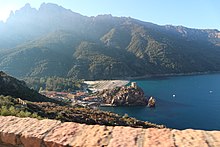
The Gulf of Porto is on the rugged west coast of Corsica. The bay with its rugged rocky coasts is protected as a world natural heritage.
places
Places on the Gulf of Porto from north to south:
- Girolata - The small coastal town can only be reached on foot or by boat. Girolata has an old fort and a beautiful bay with a pebble beach, which also serves as a natural harbor. There is excursion gastronomy. The best way to start a hike to Girolata is from the parking lot near the coastal road or half of Osani (see also section hike)
- Osani - Village just below the coastal road, which is north of Partinello. The place has its own beach with a campsite (accessible via the D 424).
- Partinello - Village on the Küsterstrasse north of Porto. The local beach is accessible via the small D 324.
- Serriera - Village north of Porto with a beach. The "Plage de Bussaglia" can be reached from the coastal road via the D 724.
- postage - "Center" of the region with pier, beach, overnight accommodation, refreshment stops and shopping opportunities. There are also a few campsites.
- Ota - Located high on a summer terrace in the interior of the island. The mountain village forms a municipality with Porto. Ota is the starting point for a walk to the famous Genoese bridge.
- Piana - beautiful village located in the southern part of the bay. It is located on a high terrace about 400 m above sea level. To the north of Piana there is the "Calanche", a particularly beautiful and rugged stretch of coast that is heavily visited in the high season. The small D 624 branches off from the D 824 west of Piana and winds steeply down to the small beach "Ficajola" on the Gulf of Porto. High above the sea, the D 824 runs further south down to "Plage d'Arone", the main beach of the town. However, this beach with a campsite is no longer on the Gulf of Porto. On the D 824, halfway from Piana, there is also the parking lot for the hike to Capo Rosso.
Other goals

background
The Gulf of Porto is part of the Corsica Regional Nature Park (Parc naturel régional de Corse), which was founded in 1972. The 3,500 km² large park area extends in the interior of the island over the high mountain massifs with the Lac de Nino to the Col de Bavella in southern Corsica. www.pnr.corsica (French).
language
The official language is French.
getting there
Nearest airports are Ajaccio and Calvi.
We recommend arriving by rental car from here.
mobility
It is best to travel with your own vehicle. It is not known to what extent public buses run along the coastal road and via the D 84 towards Corte (via the Col de Vergio).
Tourist Attractions
The coastal road can be seen as the first attraction. The many curves result in new and attractive sea views.


activities
- Swimming: I.a. Porto has a pebble beach.
hike
Sturdy shoes with non-slip soles are important for all hikes. Mountain hiking sticks are also useful. You should also bring sun protection and enough to drink with you.
Hike from Osani to the beach "Cala i Tuara" and to Girolata
From 1 Parking lot at the Col de la Croix at a height of 250 m you can get to the pebble beach "Cala i Tuara" in about 3/4 to an hour 8 descend. The bay is completely free of buildings. It takes about 2 to 2.5 hours to get to Girolata (7 km route). Good to know: a few hundred meters below the parking lot, there is a well with spring water on the hillside path, with which you can wash the sweat from your face again from the ascent.
Hike to Capo Rosso
The rugged Capo Rosso borders the Gulf of Porto to the south. The "Tour de Turghju" stands on the 250 m high cliff. The old watchtower is only accessible on foot. The starting point for the hike to Capo Rosso is 2 Parking lot "Capo Rosso" on the D 824. Although it is just 3 km as the crow flies to the tower, you should plan at least 2.5 to 3.5 hours walking time for the way there and back. From the parking lot at a height of 300 m, you first descend to a height of 100 m before a steep final climb up to the tower.
Hike into the Spelunca gorge

A possible starting point for the hike into the Spelunca gorge is the valley bend of the D 124 in the Spelunca valley at an altitude of around 250 m. According to the aerial photo in the network, there is probably one at the road widening 3 Parking on the D 124 near the entrance to the Spelunca Gorge for around 10 vehicles. That is a worth seeing destination / turning point in the gorge 4 Pont de Zaglia in the Spelunca Gorge.. From here the hiking trail climbs steeply for around 500 meters to the mountain village of Évisa. The hike can also begin in Ota instead of at the D 14 valley. You come to another one 9 Genoese bridge "Ponte Vecciu" past.
Short hike to the ruined village of Tassu
The little abandoned one 10 Ruined settlement "Tassu" can be found at an altitude of almost 700 m on the hiking trail "Mare a Mare Nord" between the mountain villages of Évisa and Marignana. You can see some house ruins that have been "enchanted" recaptured by nature. Access: From Évisa on the D 84 it is about 3 km easy with about 200 meters in altitude. According to Openstreetmap, there is a small parking space in the center of Évisa. The access from the mountain village of Marignana is a little shorter and significantly more level (2 km easy, a few small inclines in the way).
Ascent of the Capu d’Orto (1294 m)
Demanding mountain hike, detailed information about the nature of the path (no fear of heights, possibly climbing spots) are not available. From 5 Parking lot "Capu d’Orto" on the coastal road at an altitude of 500 m it is about 800 meters to the summit. The exact walking times are not known. The rather short, but very steep, demanding route can be assessed as a day tour with at least 5 to 6 hours walking time according to aerial photos.
Hike from Castellu di Vergio to Lac de Nino
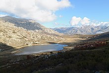
The alpine tour to the 11 Lac de Nino (1750 m) runs along the main ridge of the island. Travel time from Porto on the D 84 about an hour. The route starts on (6 Car park at Castellu di Vergio (1400 m), Hotel at 1400 m altitude near the road pass of the same name). Through the original mountain pine forest, the GR 20 first descends a little before you get to the 12 Pass "Bocca San Pedru" (1452 m) ascends (1452 m). From here you are in open terrain with many valley views. The GR 20 leads from here steadily uphill to the 13 Bocca a Reta at an altitude of 1883 m. Before here, a detour to the Capu a u Tozzu (2007 m) 14 at. The path shown in Openstreepmap over the scree west ridge of the Capu a u Tozzu does not exist in reality. From Bocca a Reta, on the other hand, it is uncomplicated over grassy terrain and meadow-like dwarf juniper stands up to the summit.
Walking time 7 to 9 hours at around 1000 meters in altitude. Technically, the route hike over the GR 20 is rather uncomplicated for a mountain hike. A head for heights is actually not required. On the western slope of the Capu a u Tozzu there is a small, quite harmless "ridge path". Here it is a little steeper downhill directly on the path. The path is easy to find when the weather is clear.
If you want, you can also go on a circular hike around the Capu a u Tozzu (with an easily passable, old mule track in the mountain forest north of the Capu a u Tozzu bei 1 ). Then you should calculate 10 hours because the 7 exposed "normal ascent" Lac de Nino with climbing areas is very exposed and contains a few smaller climbing spots (orientation is sometimes difficult here, GPS is helpful and a few cairns also show the way). It is therefore best to climb this steep section on a circular tour. The 8 Start of normal ascent to Lac de Nino on the D 84 at an altitude of 1008 m at an altitude of 1080 m is on the D84 (walking time about 3 to 3.5 hours easy).