The Iditarod Trail is the road that connects Seward, Alaska with Nome, Alaska and the rest of the Seward Peninsula.
Understand
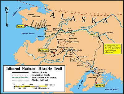
This road was mapped in 1908 as the Seward-to-Nome Trail. It was used to get people to the gold fields of Iditarod/Flat and Nome, in that time by foot or dog sled. The road mostly followed old trails of native Indians and Eskimos. The road is the only National Historic Trail in Alaska. The path of the trail has shifted somewhat over time.
There is a yearly dog sled competition from Anchorage to Nome, the Iditarod Trail Sled Dog Race, in early March, commemorating an emergency delivery of diphtheria antitoxin serum in 1925 by dog sled, partly along this trail.
Prepare
If you intend to complete the itinerary by car, you should use a four-wheel drive vehicle. Most of the trail is unpaved between Knik and Solomon. Make sure you have a few spare tires, maybe an extra car battery, and some gasoline too. There are very few gasoline stations along the Iditarod Trail. Most towns are 50–80 miles apart in between Ungalik and Knik, some distances are even longer. You should also carry other emergency supplies such as food and water for up to five days, and a few blankets. Do not count on your cellphone for help, as very few towns in Alaska have any cell service. Temperatures can go far below zero, so be prepared!
In winter the trail can be explored by snowmobile, ski or dog sled.
See Winter driving and Cold weather for more general advice.
Get in
To get in, you have to somehow get to Seward or Nome. You can take the Alaska Marine Highway to Seward, or fly into the Seward Airport, among other ways.
Drive
The best way to go on this road is to drive.
- Mile 0 - Seward
- Mile 4 - Bear Creek
- Mile 7 - Bear Lake
- Mile 28 - Moose Pass
- Mile 65 - Portage
- Mile 75 - Girdwood
- Mile 116 - Eagle River
- Mile 127 - Chugiak
- Mile 145 - Knik
- Mile ? - Susitna
- Mile ? - Old Skwentna
- Mile ? - Rohn River Roadhouse
- Mile ? - Farewell Lake
- Mile ? - Big River Roadhouse
- Mile ? - McGrath
- Mile ? - Takotna
- Mile ? - Flat
- Mile ? - Iditarod
- Mile ? - Dikeman
- Mile ? - Dishkakat
- Mile ? - Kaltag
- Mile ? - Unalakleet
- Mile ? - Shaktoolik
- Mile ? - Ungalik
- Mile ? - Bald Head
- Mile ? - Moses Point
- Mile ? - Elim
- Mile ? - Walla Walla
- Mile ? - Golovin
- Mile ? - Solomon
- Mile ? - Nome