Traveling has changed a lot in the last few years - also due to the internet. Not only that, bookings and research about the destinations are carried out via the Internet. The internet has also brought people together from all over the world and from different backgrounds to realize projects that would otherwise be unthinkable. The Wikipedia projects are one of the best-known projects, as are a multitude of other so-called projects Open projects.
In addition to the knowledge and software projects, a very interesting project has emerged that provides everyone with data for maps - that is the project OpenStreetMap. Many things arose from this project that make the use of this data possible, including the Roaming fee free use abroad.
In most cases, on vacation you want to have peace and quiet and enjoy. For some, you can be reached almost anywhere in the world via the Internet, which in turn makes long journeys possible because you are not completely away for the bosses.
Internet access while traveling
With a mobile phone
It doesn't have to be a smartphone. A simple cell phone is often enough to stay in touch at least via email. If you want to save time and money while surfing on your cell phone, you can use a browser such as Opera Mini, which reduces the amount of data by around 80 percent.
With a UMTS modem
The same applies to this as to the use of a mobile phone. However, only UMTS networks can be used. See the Wikipedia article UMTS modem.
Via a WLAN / WiFi hotspot
See the Wikipedia article Hot spot.
In an internet café
Internet cafes can be found mainly in larger cities. But some city and community libraries in smaller towns in Germany also offer internet workstations for a small fee. See the Wikipedia article Internet cafe and the section Post and Telecommunications at the individual locations.
OpenStreetMap
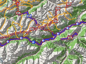
Until a few years ago, maps were only known in printed form. Maps can also be accessed in digital form via the Internet. The most famous maps initially came from Google Maps and Bing. In addition, the technology for navigation systems developed so far that these devices became affordable for everyone. Maps from these sources give users only a very limited right of use. With the establishment of the Open Data project OpenStreetMap (short: OSM) in 2004 this changed.
Contrary to popular belief, the OpenStreetMap (→ Wikipedia) not the card that you see as the end product. Rather, OpenStreetMap is a huge "data pot" (database) in which freely accessible spatial information (geodata) can be stored. The data are freely accessible to everyone and are subject to Open Database License. The free accessibility of the geodata is the special thing about OpenStreetMap. It allows you to evaluate this data according to your needs. In the sense of Wikivoyage, these cards have to be created according to the respective requirements. Maps in the Wikipedia projects are often based on the OpenStreetMap data.
As with many free projects, there are also splits and these should not be left unannounced here. For example these are Ccbysa fork and Fosm.org.
In the context of the free projects, a large number of projects have developed that allow evaluations for maps and navigation. The majority of the results from these projects can also be used freely.
What you don't see on most maps based on OpenStreetMap are the data that are contained in the project. Often users think that one or the other piece of information is missing. These are often not shown because they do not match the topic or have been omitted for reasons of clarity.
Another advantage of OpenStreetMap maps over those from other sources is the fact that it is a Non-profit project acts. For this reason there are often relatively good maps where a commercial company would not implement them.
The quality the data in OpenStreetMap varies from region to region. The best quality can be found in the northern European countries. In the other regions it depends on the respective interest in participating in such projects. Another aspect is the frequentation by OpenStreetMap contributors (called mappers).
Here are some examples of maps based on OpenStreetMap (not all maps are available worldwide!):
- OpenStreetMap map on the international project website
- OpenStreetMap map on the German project page in German style
- OpenTopoMap
- OpenCycleMap - Card for the cyclist
- Riding and hiking map
- Waymarked Trails - hike - Bike paths - Mountain bike - Inline skating (with mountain relief)
- OpenPisteMap - for winter sports enthusiasts
- OpenSeaMap - Map for travelers on the water (OSM partner project).
- Map on the topic of local public transport (ÖPNV)
Route planning
The planning of a route has to be considered from two points of view. On the one hand, the one to plan a trip in advance and the one on the trip itself. The basic planning takes place if you use digital maps, mostly at home and here two different forms are available. On the one hand, the planning via one of the many web portals where no software has to be installed on the local computer. On the other hand, there are a large number of programs that integrate data into locally installed software. In these cases, the same data can often be used as for the subsequent trip itself. The basic planning functions are similar in both variants. Digital map material can be found in the appropriate specialist shops or (mostly) from independent projects - generally based on OpenStreetMap. Which data is better for you, you have to judge depending on the region. The advantage of the data from the free projects is that they can be checked in advance. There are usually no test versions of the paid products; examples of the corresponding software
- gpsies - Web portal for route planning
- Qmap - (Windows, OS X, Linux)
- Basecamp - Software from GARMIN for their maps or from other sources (e.g. OSM leisure card)
- … please complete
Many programs allow a differentiation in route calculation between car, cyclist and hiker. For cyclists, it is advisable to first do a route calculation for hikers and then one for cyclists. The result then has to be coordinated because the cycling route may be considerably longer due to a traffic ban - it would be enough to take a shortcut to take the shorter route.
Use of free cards without roaming charges
The classic navigation device for hikers is the outdoor receiver as it has been around for several years and can also be used by motorists. With these devices, the maps offered are imported into the device and can then be used for the relevant outak area by every connection to the “outside”.
With the widespread use of mobile telephones and netbooks in recent years, navigation via them has also become an everyday aid and has displaced special car navigation devices in some areas. What may work well at home is often associated with high roaming charges abroad, as these programs often need a connection to the Internet and only download the necessary data when required.
For the cost-conscious vacationer it is important to consider how to avoid this possible cost trap. Here again, cards from free projects are available.
Outdoor GPS devices
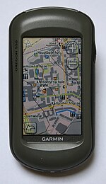
Devices of this class are usually always provided with the data in advance, but nevertheless, and for the sake of completeness, some map sources, in addition to those from the manufacturer, should be mentioned at this point.
- Riding and hiking map
- Computer teddy
- Leisure card
- … please complete
In the following, the steps are briefly described in order to be able to integrate this map material into the corresponding devices. A more detailed overview of cards and hardware can be found in the OSM Wiki.
Garmin maps
Android maps
iphone cards
Cards for other hardware
Project support through feedback
Communication in the OpenStreetMap project takes place primarily via the Internet in the associated OSM Wiki, Mailing lists or that Forum. Anyone who would like to make direct contact with the contributors can do so in Germany at one of the numerous OSM round tables. Where the next is found is that German project site to be taken (red circles).