| Kuna Yala | |
 | |
Location 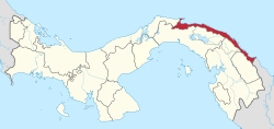 | |
Flag | |
| State | Panama |
|---|---|
| Capital | El Porvenir |
| Surface | 2 393 km² |
| Inhabitants | 33.109 (2010) |
Kuna Yala or Guna Yala is an autonomous territory (comarca) of the Panama.
To know
Kuna Yala is the territory of the indigenous Kuna people. The name means "Terra Guna" or "Mountain Guna" in their language.
Renowned above all for the myriad of islands that dot its coast, which extends for more than 200 km up to the borders with the Colombia.
Background
This area was originally known as San Blas and later as Kuna Yala, but the name underwent a change in October 2011 when the Panamanian government recognized the complaint of the Guna people and, as there was no letter or phonetic in their native language "KA", the name became "Guna Yala".
Territories and tourist destinations
The comarca is not divided into districts but has four corregimientos: Narganá, Ailigandí, Puerto Obaldía, Tubualá.
Urban centers
- El Porvenir - Capital of the province.
- Rio Sidra
Other destinations
- Nalunega — Ukuptupu, Wichub-Walá - A stone's throw from capital, the three islands are among the most popular of the archipelago.
- Nusatupo is Isla Robinson