 | ||
| Lospalos | ||
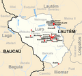
| Country | Lautém municipality | |
|---|---|---|
| Residents | 12.743 (2010) | |
| no value for residents on Wikidata: | ||
| height | 346 m | |
| no tourist info on Wikidata: | ||
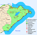
| location | ||
| ||
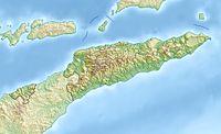
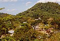
Lospalos (Los Palos) is the capital of Lautém, the easternmost municipality East Timors. Tourist highlights are not numerous in this place, but it is a starting point for the beauties in the area. Lospalos is about 150 km east of the state capital Dili as the crow flies. It is 248 km by road to Dili.
background
Geography and inhabitants
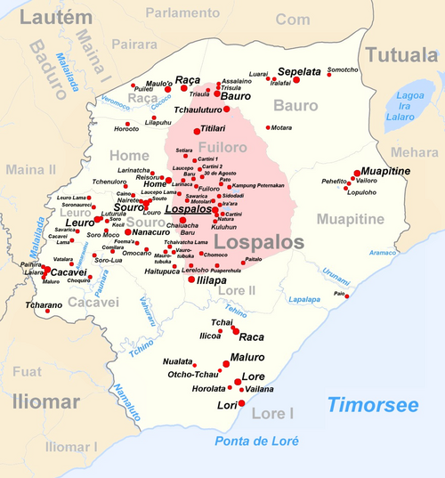
The place does not form a closed settlement, but is distributed widely into individual small settlements and hamlets throughout Suco Fuiloro. The Suco is named after the settlement Fuiloro, about seven kilometers north of the center of Lospalos. With a total of 12,743 inhabitants (2010), Lospalos is the fourth largest city in East Timor. The administrative office of Lospalos has 29,712 inhabitants. With an area of 635 km², the administrative office is the largest in East Timor and is divided into ten sucos: Bauro, Cacavei (Cacaven, Cacavem), Home, Fuiloro, Leuro, Lore I (Loré I), Lore II (Loré II), Muapitine, Raça ( Raca) and Souro.
The largest language group are the speakers of the regional national language Fataluku. Other languages in the municipality of Lautém are Makasae in the southwest and the almost extinct language Makuva in Mehara (administrative office Tutuala). The official languages Tetum and Portuguese are mostly not the native languages of the residents, however Tetum is widespread and Portuguese is taught in school from secondary level. English speakers are not easy to find. In addition to the overwhelming Catholic majority, there is a small Protestant community with the small church in Lospalos Immanuel and the mosque Masjid Al Taowa Lospalos, but slowly crumbling into ruin.
The northeast of the administrative office is part of the Fuiloro Plateau, which due to its size drops imperceptibly from north to south from 700 to 500 m above sea level. It is the remnant of a prehistoric lagoon. There is a relatively intact forest in Lore I. Here you can find teak, sandalwood and bamboo. The flat and slightly hilly landscape around Lospalos is ideal for growing rice, maize and other cereals.
history
The Portuguese were the first Europeans to reach the region in the 17th century and founded a fort in Lore I. The area remained one of the most remote outposts of the colonial empire. In the town Lautém there was a Portuguese country estate and a fortress, and a district governor resided in Tutuala.
The Japanese occupied Timor from 1942 to 1945 and the Indonesians from 1975 to 1999. In the context of the independence referendum in 1999, the pro-Indonesian militia raged Team Alfa in the then district. Houses and public facilities were destroyed, and pro-independence advocates and Christian clergy were murdered. Only with the arrival of the United Nations blue helmets did calm return. In 2002 East Timor gained its independence.
getting there

In the street
Large intercity buses (Biskota) connect Lospalos with the major places in the country, such as over Com and the place Lautém With Baucau (3.5 hours) on the north coast and on to Dili (a total of 7 hours). A road also leads to it Viqueque in the south-east of the country, but this is in poor condition, which is why it is more pleasant to travel to Viqueque via Baucau. Many buses leave the market, but there are other stops as well. The best thing to do is to ask the locals where and when which bus leaves. The fare is a few US dollars.
The minibuses also depart from the market (Mikrolét), with which you can reach the small towns in the area. While the road to Dili is well developed, the other roads are mostly slopes with many potholes, some of which become impassable in the rainy season.
mobility
The region is relatively level ground by Timorese standards, which is why cyclists who are not quite as fit have a chance here. However, there is no rental. So it's best to look for a lift or explore the place on foot. It is of course practical if you have already rented a jeep or a motorcycle in Dili.
Tourist Attractions
Suco Fuiloro
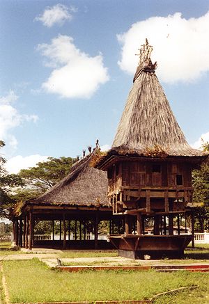
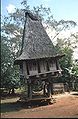
The real eye-catcher in Lospalos is the traditional, holy house and the covered meeting place next to it. It was built in the 1990s. In Fataluku one calls the houses with the steep thatched roofs Lee-teinu, in Tetum Uma Lulik. In earlier times, sacred objects of the animistic religion were kept in them. They are typical of the Timor region inhabited by Fataluku. Sometimes they are found worse, sometimes better preserved, for example in Com or Iralafai (Suco Bauro). Two more Lee-teinu can be found in the settlement Titilari, in the north of the Sucos Fuiloro. In 2003, they were in poor condition. In the meantime, however, they have become a national symbol of all of East Timor and their steep roofs can be found in many modern buildings, for example at Dilis Airport or on the palace of the President. The Catholic Church of Lospalos also crowns the roof of a Lee-teinu. There is also a building from the Portuguese colonial era.
It is possible that remains of the Portuguese fortress can still be found in Fuiloro. There is also an airfield here, which was used by the Japanese, among others, during World War II.
Don Bosco College is one of the better known educational centers in the country. An art and culture center has been under construction in the old market building since the end of 2012. It is intended to present the diversity of the Lautéms community.

Don Bosco College
Protestant Church Immanuel

Catholic church with traditional roof
Holy house in Titilari


Suco Bauro

In Iralafai there are three lee-teinu. The Suco is part of the Nino Konis Santana National Park.
Suco Lore I.

An area around Lore with 10,906 hectares with its forest and the surrounding rice fields has been designated as an Important Bird Area by BirdLife International. Here you can still find teak, sandalwood and bamboo, in which at least 24 protected bird species live, such as the green Timor pigeon or the yellow-cheeked cockatoo. The largest remaining coastal forest on the entire island of Timor is also located in this area, about 40 km south of Lospalos. In 2007 it became part of the Nino Konis Santana National Park. There may also be remains of the old Portuguese fort from the 17th or 18th century.
In addition to sugar production, schnapps distillery is a lucrative branch of the village. The schnapps is sold in Lospalos.
Suco Lore II
A small suco on the edge of the Nino Konis National Park.
Suco Muapitine
A large part of the Lagoa Ira Lalaro, the largest lake in East Timor, is located in the northeast of the Sucos, which extends into the administrative office of Tutuala in the rainy season. The lake loses a large part of its surface in the dry season and then disappears from the suco. The Suco is part of the Nino Konis Santana National Park.
Suco Raça
On the way from Lautém to Lospalos you pass Raça. The village is 16 km from the north coast and 12 km from Lospalos. Two of the most beautiful holy houses in the region used to stand here, but they have disappeared in the last few years of the Indonesian occupation.
shop
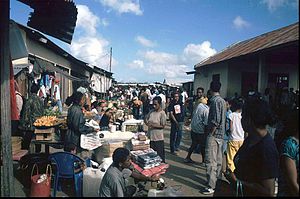
The old market building burned down completely in the 1999 riots. Today the market is in Kural, which lies between Fuiloro and Lospalos, consists of a series of stalls selling agricultural products and small goods.
As in other parts of the country, the traditional woven fabrics are the Tais, a nice souvenir. The fabrics differ depending on the region.
kitchen
Small dishes and groceries are available at the market. Some small restaurants in Lospalos also offer food, so that 27 @ restaurant and the Mini café Lospalos at the roundabout by the Protestant church.
accommodation
Accommodation is rare. For example, in restaurants you can ask if there is a back room with a bed, so im Esperança Restaurant & Guest House at the roundabout for about $ 8. in the Ayr Restaurant & Guest House breakfast is available for a few dollars more. Another hotel is this Hotel Roberto Carlos. The pastor of the church or one of his parishioners may also have a bed to rent.
Practical advice
Opposite the mosque is the local government office, to the left of the mosque, down the street has the local radio station Rádio Comunidade de Lospalos RCL his seat, where you might get some information. There is also a police station and a community health center in Lospalos. Emergency medical help can also be found in the other main locations of the administrative office.
trips

- Administrative office of Iliomar. The region on the Rio Irebere is particularly interesting for ornithologists. There are also remnants of the Portuguese colonial era on the coast, such as an old lighthouse. There used to be a port here. The post was founded in 1904, but has long since expired. The road between Iliomar and Lospalos is repeatedly interrupted for a long time due to damage from the rainy season. (In the wikipedia: Iliomar).

Ruins at Iliomar
Lighthouse in Iliomar
Iliomar Beach


- Administrative Office Lautém. An old Portuguese country house and a colonial fortress are the main attractions of the place Lautém. Cave drawings that are thought to be several thousand years old have been found near the town of Lautém. In Com there is a small resort on the beach and a traditional holy house. Com is part of the Nino Konis Santana National Park. (In the wikipedia: Lautém).
- Luro administrative office. The Lautém mountains and one of the most remote regions of the country. (In the wikipedia: Luro).
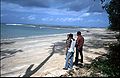
- Tutuala. Tutuala forms the far east of the country. The place Tutuala can be reached in a few hours by car or Mikrolét, past the place Mehara. This is a little south of the road Ira Lalaro, East Timor's largest lake. At the eastern tip is the small, uninhabited island Jaco with a beautiful sandy beach and good snorkeling opportunities. The administrative office is partially wooded and, like the surrounding sea, belongs completely to the Nino Konis National Park. Tutuala forms the core of the country's first national park. In Ile Kére Kére, one of the many limestone caves, there are paintings up to 5000 years old. (In the wikipedia: Tutuala).
Tutuala

Ile Kére Kére
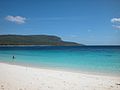
Jaco Island Beach


Next maps of the municipality of Lautém

Boundaries of the municipality since 2015

Iliomar until 2015

Lautém until 2015
Luro until 2015
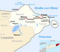
Tutuala since 2015
Nino Konis National Park


Web links
- In the Wikipedia portal East Timor you can find articles on all sucos and administrative offices of the municipality of Lautéms.
- Large format map of the municipality of Lautém (Archived version of June 30, 2007 in the Internet Archive archive.org) (Attention: PDF with 7.17 MB)
- Discover Dili: Los Palos (English)