 "Maze Cave", part of the underground Maresha | ||
| Marissa | ||
| District | Southern District | |
|---|---|---|
| Residents | 0 () | |
| height | unknown | |
| no value for height on Wikidata: | ||
| Tourist information Tel | (0)8-681-2957 | |
| no tourist info on Wikidata: | ||
| location | ||
| ||
The "cave city" Maresha lies in one Archaeological Park near the kibbutz Bet Guvrin in the Schefela in southern Israel.
background
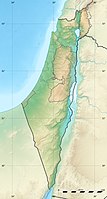
The Archaeological Park of Maresha is south of the road 35 at the kibbutz founded in 1949 Bet Guvrin.
A first Israelite fortified city arose on the settlement hill of Maresha under Solomon's son, King Rehoboam, around 920 BC, 587 BC. the city was destroyed by the Babylonians. After returning from Babylonian captivity, the Jewish people found the region of the Edomites (Idumeans) settled before which Maresha had made their capital.
In the fourth century the place was colonized by Phoenicians and was considered Greek Marissa designated. As a result, the city changed hands several times; the Ptolemies and the Seleucids ruled, who ruled over the Idumeans who continued to live here. Around 40 BC. the city was destroyed by the Parthians on one of their campaigns; they were allied with the Hasmonean king Antigonus and turned against Herod, who was of Idumaean descent and whose family possibly came from Marissa.
In contrast to the twin city a little to the north Bet Guvrin Maresha was no longer repopulated.
In 1838 the American archaeologist Edward Robinson identified it Bethgebrim than the ancient Eleutheropolis, around 1890/1900 excavations were undertaken by P. G. Bliss and A. S. Macalister, in 1902 by H. Thiersch and J. P. Peters die Sidonian burial caves discovered. It was not until the 1960s and 1970s that the site was systematically excavated by Y. Ben Arieh; a team under A. Kloner carried out an exact exploration of the site in 1989/2000, and the excavation work continues.
getting there
By plane
Most overseas travelers will be by air via the Ben Gurion Tel Aviv Airport arrive.
By train / bus
By rail you can take the trains of the Israel Railways to Kiryat Gat arriving) every 30 minutes during the day Tel Aviv, Travel time 40 minutes, from there you can only continue by bus. The buses of the lines 11 the bus company Egged drive the kibbutz from Bet Guvrin twice a day. The ruins of the old Bet Guvrin with the aphitheater are relatively close by, a considerable walk (3 km to the end of the park) is to be taken into account to the excavations of Maresha.
In the street
From the main street 40 which from the greater area Tel Aviv resp. the Ben Gurion Airport at Lod and Rehovot leads past in a southerly direction, goes ahead Kiryat Gat the main road 35 in an easterly direction. There is also an exit from the newly opened toll motorway here 6. The kibbutz Bet Guvrin is east of the road, in the national park Bet Guvrin - Maresha it goes on the right hand.
mobility
From the road junction from the main road to the first sights of the Maresha National Park you have to cover about 800 m and for the circular route a total of 6 km; These distances are less strenuous to cover with your own vehicle, especially in the summer heat; there are parking spaces at the various sites in the National Park.
The ruins of the ancient Bet Guvrin with the amphitheater are close to the main road and within easy walking distance.
Tourist Attractions
Maresha National Park


- 1 Bet Guvrin - Maresha National Park. Tel.: 972 (0)8-681-2957, 972 (0)8-681-1020, Fax: (0)8-681-2957. Open: Summer 8 am-5pm, Oct-March 8 am-4pm.Price: 29/15 NIS.
The various sights in the area can be reached on a ring road and are also connected by footpaths:
- 2 Northern Cemetery (Kokhim Cave): The first caves can be reached via a short footpath from an exhibition space on the driveway. In addition to a grotto with a natural hole in the ceiling, burial niches have been cut into the soft limestone. Immediately behind it is the entrance to an underground grave cave with burial niches tapering to a point at the top. Century B.C. used.
You now come to a parking lot (Parking A) with toilet facilities and drinking water points.
- On the left side of the street there were several in a didactic center agricultural facilities reconstructed resp. set up again. Here you will find an olive press and a threshing floor. Behind it lies a large fund of various architectural elements, column drums, capitals, sarcophagi, millstones - brought together from all over the area.


- on the right is the access to 3 Polish Cave. In this bell-shaped cave, numerous niches are set into the walls, the complex from the 4th-3rd centuries. Century B.C. initially served as a cistern and was later used as a dovecote ("columbarium"). Here the pigeons were bred as sacrificial animals for temple service and also as food, the manure was used as fertilizer. In 1943, soldiers of a Polish unit carved the words "WARSAW POLAND" and the Polish heraldic eagle, which gave the cave its name, into a rock rising up like a pillar in the middle of the cave "Polish Cave" gave.


- a few steps further you step into the 4 Columbarium Cavewho have favourited the dovecote. This huge cave in the form of a double cross was built in the 3rd century. B.C. knocked out of the soft stone. The two thousand niches were also used for pigeon breeding, later as a storage room.
From the next parking lot (Parking B, with a water point) you can climb up to the left to Tel Maresha, the settlement hill, on the right a path leads to further caves.
- the settlement hill 5 Tel Maresha was practically razed on the occasion of the conquest of the city, only on the slopes are ruins of the Hellenistic city with remains of fortifications in the northwest. From Tel Maresha you have a beautiful view of the surrounding hill country Schefela.


A path to the right below the road leads to further underground structures.
- in the 6 Bath Cave There were two small subterranean rooms in which there were basins with water drains; bathing was probably carried out here (possibly for ritual cleansing).
- next to it is the Olive Press Cave. Not only here was an entire underground olive press found, including the round mill, whose millstone, moved by an animal, crushed the olives, and the elongated presses in which the olive puree in sacks was pressed from tree trunks with weights. To make the work easier in the heat of the day, olives were processed underground here.
- The 7 Cave Dwelling (House with cisterns) may have belonged to a water trader. Imposing on the building from the 3rd century. B.C. with the above-ground courtyard, surrounded by smaller rooms, is the width of the rooms that open up when you go down the "cellar stairs". Immense cisterns can be found under the living rooms, to which the rainwater was fed through a system of gutters and clay pipes; Spiral stairs allow you to descend to the water level. Huge rooms next to it were created by using the subsoil as a quarry; work could also be carried out here without being exposed to the heat of the day.


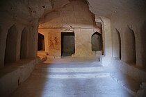
- the path continues to the so-called 8 Maze Cave, the labyrinth cave. An unspectacular staircase leads you into a real labyrinth of underground cisterns, warehouses - you come across dovecotes with countless niches, an olive mill and an oil press. The exit from the underground world should be 100 m from the entrance.


The driveway leads down to the visitor center with a souvenir shop, toilet facilities and laid picnic tables. In the immediate vicinity are the Sidonian burial caveswhich are typical of burial sites from the Hellenistic period in Maresha.
- the 9 Apollophanes Cave, a burial site with a T-shaped floor plan with numerous burial niches. The frescoes in this cave showed animals from the world of adventure and mythology of the Sidonnians, Idumeans and Greeks, inscribed in Greek. An inscription refers to Apollophanes, son of Sesmaios, head of the Sidonian Community of Maresha and thus proves the correct localization of the ancient Maresha.
- the 10 Cave of the Musicians takes its name from a fresco of a lute and flute player, the frescoes have also been reconstructed.


A footpath leads north past other caves, past the ruins of the
- 11 St. Anna Church: The 52 x 56 m large Byzantine Church of St. Anne was destroyed after the Arab invasion and rebuilt in the time of the Crusaders with a more modest floor plan. The name was derived from the Arabic term "Tel Sandahanna" for Tel Maresha.


On foot further north or on a spur road with the vehicle you get to the Parking lot D (also with shade and toilet facilities):
- 12 "Bell Caves": the huge bell-shaped caves were dug into the ground in the Byzantine and early Arab times as quarries in the outskirts of Bet Guvrin. After the vegetation and the uppermost hard rock layer had been removed, the soft white limestone in the subsoil was found. This was removed in layers from above, and the cave was widened in the shape of a bell downwards. Since the only access was at the top, and the connections between the eighty caves were not made until much later, the stones had to be lifted up with a rope hoist. Not only the buildings of Bet Guvrin but also the buildings of numerous other cities on the coastal plain were built from limestone from these stone bridges.


Visiting the north of the road 35 excavations of the Roman city are included in the entrance fee:
- the 13 roman amphitheater belonged to the public buildings of the Roman city Bet Guvrin / Eleuteroplis, of which a number of ruins are still being explored, including ruins that have become more extensive 14 Thermal baths exposed.
- In the same area are the ruins of the 15 Crusader castle
activities
The focus is on visiting the archaeological site of Maresha and the Roman settlement near Bet Guvrin with the amphitheater. Some hike on the Israel Trail past the site.
Especially in spring, the poppy fields in the Schefela around Bet Guvrin are a magnet for local visitors.
shop
There is a grocery store in Kibbutz Bet Guvrin. In the national park administration's souvenir shop at Parking lot C snacks, drinks, ice cream as well as books and brochures as well as souvenirs are offered.
kitchen
In the national park administration's souvenir shop at Parking lot C snacks and cool drinks are offered.
nightlife
The national park closes at 5 p.m. in summer, the nightlife takes place in the cities in the vicinity.
accommodation
health
Practical advice
There are toilets and drinking water points at parking lots A, C, D and E (at the petrol station); only the circular route and parts of the Bell's Caves are with the ![]() wheelchair accessible, which are mainly interesting underground caves / buildings with a basement
wheelchair accessible, which are mainly interesting underground caves / buildings with a basement ![]() Not wheelchair accessible, so that a visit to the park is only partially worthwhile for people in wheelchairs and people with walking disabilities (in the caves / caverns it is up and down stairs). The Bell's Caves are worth seeing in themselves and the summer heat there in the coolness is bearable.
Not wheelchair accessible, so that a visit to the park is only partially worthwhile for people in wheelchairs and people with walking disabilities (in the caves / caverns it is up and down stairs). The Bell's Caves are worth seeing in themselves and the summer heat there in the coolness is bearable.
trips
- in the vicinity there are various caves and other ancient settlement traces for which the Schefela is known.
- Caves of 1 Khirbet Midras or Horvat Midras also with columbaria (dovecotes), part of the Adullam Grove Nature Reserve
- the ruins of 2 Khirbet Tsura or Hirbet Tzura
- the ruins on the settlement mound of 3 Tel Goded
- the ruins of 4 Khirbet Beit Loya with, among other things, a Byzantine mosaic floor
 Columbarium in Tel Goded |  Columbarium from Khirbet Midras |  Mosaic floor in Khirbet Beit Loya |