The Conguillío National Park lies in the Región de la Araucanía in the Little SouthChile.
background
| location | ||
| ||

About 85 km east of Temuco is the Conguillío National Park - also known as Las Paraguas, because the silhouettes of the araucarias, which the 60,000 hectare park was set up to protect, look like umbrellas.
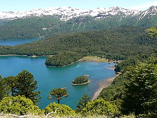
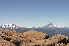
The central point of the national park is the 3,125 m high (and extremely active) Llaima volcanoat the foot of which there are some beautiful lakes.
history
landscape
Flora and fauna
climate
getting there
Fees / permits
In the high season for Chilean citizens CLP 2,500, for foreigners CLP 4,500. In the off-season CLP 1,500 or CLP 2,000. Discounts for children and seniors over 65 years of age.
mobility
Tourist Attractions
activities
A popular destination for hiking is the Sierra Nevade mountain range on the opposite side of the 1 Lake Conguillío![]()
![]()
![]() , from where there is a wonderful panorama with the Llaima volcano - provided the weather is good.
, from where there is a wonderful panorama with the Llaima volcano - provided the weather is good.


to buy
to eat and drink
Sleep
There are few simple accommodations in the park itself. The closest localities are Curacaautín and Melipeuco.
Hotels and hostels
camping
On the south bank of Lake Conguillío there is a simple Conaf campsite with cabañas (huts) for self-catering.