| Northern British Columbia (Northern British Columbia) | |
 | |
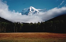
| The O'Connor Delta of the Tatshenshini River in Tatshenshini-Alsek Provincial Park | |
| Information | |
| Country | |
|---|---|
| Location | |
 58 ° 6 ′ 0 ″ N 126 ° 24 ′ 0 ″ W | |
the Northern British Columbia is a region covering the majority of the northern half of the province of British Columbia to Canada.
Understand
Northern British Columbia is a vast, sparsely populated region with vast natural areas and significant wildlife. The majority of the communities are located along the Yellowhead Highway (Highway 16) or in the Peace River area. The territory is mostly covered with forests and is mountainous.
Cities
- Atlin - town in the far north, only accessible by road from the Yukon
- Dawson creek - small town known as the "zero mile" of theAlaska Highway
- Fort Nelson
- Fort St John - second largest city located along theAlaska Highway
- Mcbride - village in the Robson valley
- Prince george - the most important service center in the region
- Smithers - ideal starting point to explore wild territories
- Yellow Head Cache – at the crossroads of two main highways
- Valemount
Other destinations
- Rivière-Stikine Provincial Park
- Tatshenshini-Alsek Provincial Park
- Mont-Robson Provincial Park
- Plateau-Spatsizi Wild Provincial Park
To go
Driving to this region will require several hours of driving. For example, in summer, from the US border, it takes about 14 h of road to get there. In winter, it takes two more hours and you must plan to bring chains to drive on theAlaska Highway.
Flights from Vancouver International Airport are available and are quite affordable when compared to the cost of gasoline to get there while driving. These flights are offered by Air Canada, Westjet and Hawkair. It is recommended to book long enough in advance.
- 1 Fort St. John Airport (IATA : YXJ, ICAO: CYXJ, Fort St. John Airport, North Peace Airport) (east of Fort St. John)