| Altai Tavan Bogd National Park Алтай Таван богд байгалийн цогцолбор газар | |
 | |
| Area type | National Park |
|---|---|
| State | Mongolia |
| Surface | 6362 km² |
| Foundation year | 1996 |
Altai Tavan Bogd National Park is a protected area located in Mongolia.
To know
Altai Tavan Bogd National Park is the largest national park in the Mongolia. It is located in the western part of the country, south of the Tavan Bogd mountain which is also the already high peak of Mongolia. Located near the border with Russia is China, from the highest peaks it is also possible to see the Kazakhstan.
Mount Kuiten Uul, 4,374m, is the highest of the five peaks of the Tavan Bogd Mountains (literally "5 Saints") which gives the park its name. It is home to three large freshwater lakes and 34 glaciers, as well as several waterfalls. The Tavan Bogd Mountains are considered sacred to Kazakh, Tuvan and Mongolian locals. The park stretches from Russia along the Chinese border, following the Altai mountain range that divides China, Russia, Mongolia and Kazakhstan, for over 200 km. Ancient tribes left behind many artifacts, using the region for religious ceremonies. Today, tens of thousands of petroglyphs in the park are part of the World Heritage Sites in Mongolia. In addition there are numerous megaliths and stone mounds.
Geographical notes
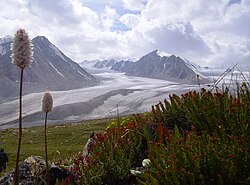
Altai Tavan Bogd has some of the most beautiful scenery in the whole of Mongolia, with white mountains, glaciers, deep lush valleys and large lakes. The park is divided into 2 regions, the Tavan Bogd Mountains to the northwest and the Lakes Region to the southeast. The glacial melt and annual snow fall provides 3 large lakes within the park that feed the waters of the Hovd River.
The Tavan Bogd Mountains are the tallest mountains in Mongolia, with Khuiten Uul ('Cold Peak') at 4,374m being the highest. These permanently snow-capped mountains form a basin around the Pontuninii glacier, the largest, covering 23 km². The other peaks are Nairamdal ('Friendship', 4,180m), Malchin ('Shepherd', 4,050m), Bürged ('Aquila', 4,068m) and Olgii ('Cradle', 4,050m). From the top of Kuiten Uul it is possible to see the Kazakhstan 30 km away on clear days. Khuiten Uul was renamed Ikh Mongol ('Great Mongol') by President Enkhbayar when he climbed it in 2006, although this name is largely ignored. There is still a monument at the base commemorating the conquest.
The "Lakes Region" is a beautiful area surrounding 3 large freshwater lakes. Khurgan Nuur and Khoten Nuur are connected by a small channel with many small coves that flow into the lakes from the surrounding mountains. Two of these streams form 7/10 m high waterfalls. A small bridge crosses the canal. These lakes are full of fish and many species of birds. Dayan Nuur is a smaller lake 20km south of the 2 largest lakes.
Flora and fauna
Inside the park there are many endangered species, including argali sheep, stone marten, ibex, gray wolves, deer, black vulture, moose, snow leopards, the tetraogallo of Altai, golden eagles and many more.
When to go
The high season runs from June to October, when temperatures are warmer, the snow has melted and tourist camps and shuttles are in operation. The busiest period is August and September, when the weather is the best for mountaineering, and also during the eagle festival period. But the park is still accessible all year round with activities like snow skiing and eagle hunting during the cold winter months.
Background
THE Altaj Mountains they have been inhabited for about 12,000 years. The oldest images of the park range from 11,000 to 6,000 BC. with large hunting mammals and ancient cultures. Thousands of years of petroglyphs show the transition from hunter-gatherer to pastoralism and then to the present semi-nomadic which has developed over the last 3,000-4,000 years. About 4,000 years ago, the use of horses and the domestication of animals led to the rise of the Blue Turks (whose language is the root of Kazakh and Turkish). These warriors left standing carved stone statues, known as Turkic Stone Men, which stretch out over the Altai Mountains.
Later, in 700 BC, a group of warrior nomads on horseback, the Scythians, began to travel from the Altai Mountains to conquer a region that stretched to the Black Sea. They disappeared after being defeated by Alexander the Great in today's Turkmenistan in 329 BC, but not before leaving many stone mounds in the Altai. These mounds, or Khirigsuur, were designed to store bodies in frozen ground with horses, weapons, armor and food for the afterlife. One such mound was discovered that contained a Shiite warrior in full battle on a 2005 research expedition. In AD 100, the Huns migrated across the region from the steppes of Mongolia to destroy theEurope around 400 AD Around this same time, the reindeer herding tribes from the Siberia, calls Tuvans, began to expand south towards the mountains.
The mountains and much of the surrounding region, including the first Silk Road to the south, fell under the control of the Uyghur-Turkish Khannate (kingdom) after AD 600. until Genghis Khan conquered it along with much of theAsia from 1260. Uighurs and Turks were incorporated into the Khan's army. After Genghis died, the empire was divided among his sons, with the Altai forming the border between the Golden Horde (Russia), Chagatai Khan (Central Asia) and the Yuan dynasty (China). The region changed hands several times due to infighting and the division of territories following the decline of the Mongol Empire. The region fell under the control of the Yuan dynasty until 1370, the year of their decline. The region was then ruled by the independent Mongolian tribes of the Oirat until the conquest by the Qing dynasty in the 18th century.
Between 1840 and 1940, many Kazakhs moved to the Altai Mountains to escape persecution and domination by the Russians and then by the Soviets and Chinese Communists. Mongolia became a satellite state of Russia after a long and bloody civil war from 1911 to 1924. For the next 70 years, Tavan Bogd was an isolated border area closed to all, but few ignored Kazakh shepherds and army patrols. .
How to get

Altai Tavan Bogd is located 180 km from the provincial capital Ölgii. It departs from the city, unless you go with a tour operator who obtains permits in advance. It will take 7 hours with stops (5 hours non-stop) due to the bumpy and non-existent roads, high mountain passes and lack of bridges, even though it is a very scenic route. Most park visitors are part of a tour group or with a guide, although many of them do without it.
Here are some of the companies that offer tours to visit the park.
- Wonderful Mongolia Travel.
- Western Mongolia Tour LLC.
- Blue Wolf Travel.
- Kazakh Tour.
- [link not working]Bulbul Jamak Travel.
Permits / Rates

Two permits are required to enter the park, a park permit and a border permit. The "park permit" is available at the Visitor Information Center of Ölgii or at one of the park ranger stations near the Tavan Bogd Mountains and on the Hovd River south of Tsengel (on the road to the lakes). Everyone should have one, which is 3000T for foreigners and 1500T for Mongols. All visitors must go to a Ranger station at the entrance to the park. There are 2 near Tavan Bogd in each of the 2 valleys approaching the mountain, plus another in Syrgil between the lakes (after the Hovd River Ranger Station).
THE Border permits they are required to travel within 100 km of an international border of Mongolia. Permits for the Chinese border area are available at the border patrol office in Ölgii (by the river, 1km west of the bridge). Permits for the Russian border are only available in the village of Tsaagannuur, near the Russian border crossing and 70km north of Ölgii. A Russian border permit is required if you go north of the Pontuninii glacier and towards Mount Khuiten Uul. It may also be requested if the rivers near Tsengel are too high to cross and require a path further north to the mountains. Russian permission is not required if entering the park near the lakes. It will be better to have a local when going to the border patrol, as they don't always like to talk to people who don't speak Mongolian or Russian. Permits are 3000T per group. If you plan to join a group and then split up in the park, you get multiple permits. Anyone who does not have a border permit will be turned back in Ölgii by the army at their own expense plus a large fine.
Fishing permits are available from June 15th to April 15th. They are available from the Nature Protection Office next to the Khaan Bank (XAAH БAHK) on Ölgii Square, or from the Tsengel Village Government. The permits are 3500T and good for the whole trip. However, you don't need a fly-fishing permit and hold for one meal only (though a guide should be consulted for appropriate limits).
How to get around
What see
What to do
Shopping
Where to eat
There are no restaurants in the park. Bring all the food you need with you. Local Kazakh foods are generally meat-based, especially in the countryside. Goat, sheep, horses, camels and cows. Most of the food will be meat, flour, possibly potatoes, and a large amount of cooking oil.
Bring bottled or boiled water and the means to purify or boil water with you when camping and traveling. Lots of water around, just take the usual precautions. When you are with the locals, you can try the local specialties: milk tea, koumis (fermented horse milk) and vodka.
Where stay
Most tour companies traveling in the park will take you to your accommodation, either in your lodge or in the set up camp. There are a few ger (yurt) camps scattered around, but you'll need to check with the park office for their current locations.
Inside the park, there are no commercial facilities, hotels, hostels, etc. Independent travelers can find accommodation with local Kazakh shepherds if they want to have a very pleasant and interesting local experience. If you do, pay them for your stay. The income opportunities for these people are very limited. Two or four dollars a night is currently acceptable and good value for the experience. When traveling further into the mountains, there is no accommodation unless you bring a tent, and this is recommended.
There are now several pastoral communities that have come together and can provide some primitive services such as lodging and guidance. Check with the park information office to find where they are if you want to visit one of these communities. It can be a great experience, but be prepared.
Safety
There are wolves, bears, foxes and other potentially dangerous animals within the park. Locals will warn you to watch out for wolves especially when traveling alone. However, attacks on people are very rare and wolves are afraid of humans. You have a better chance of being bitten by a dog near one of the camps. Another concern is animal-borne diseases. Locals eat marmots, although this can be dangerous, as they carry the bubonic plague. To ask if you are served the groundhog in Kazakh to say "soor bar but?".
How to keep in touch
Around
Other projects
 Commons contains images or other files on Altai Tavan Bogd National Park