Point Reyes is a National Seashore on the coast of California in the north of San Francisco.
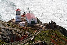
Point Reyes lighthouse
background
history
landscape
Over the course of millions of years, the entire peninsula has migrated northward along the San Andreas Fold, which lies here under Tomales Bay, along the continent.
Flora and fauna

Tule elk at Tomales Point
climate
getting there

Environment map
- The park can be reached from San Francisco on US Highway 101 north, and from Exit 450B on Coastal Highway 1 after about 35 miles.
- The route completely along CA-Highway 1 is a little longer at 40 miles, but consistently very curvy and therefore slower.
Fees / permits

Overview map
mobility
- no gas stations on the peninsula
Tourist Attractions
- lighthouse
- Bear Valley Visitor Center
- Sea rescue station
- farm
activities
- Watch whales