
| Radowo Małe | |
 | |
| Arms | |
 | |
| Map | |
 | |
| Information | |
| Country | Poland |
| Region | West Pomeranian voivodeship |
| Surface | 180 km² |
| Population | 3.728 |
| Area code | 48 91 |
| Postal Code | 72-314 |
| website | |


Radowo Małe - (German: Klein Raddow) - a village in north-western Poland, located in the West Pomeranian Province since 2002, in the Łobeski County. The seat of the Radowo Małe commune. In the years 1975-1998, the town administratively belonged to the Szczecin Province. The Radowo Małe commune is located in the center of Western Pomerania and in the center of the Łobeski poviat. It neighbors with the Resko, Łobez, Węgorzyno and Dobra communes. The commune comprises 28 villages covering an area of 180 km², inhabited by 3,728 people. 65% of its area is arable land, 26% is covered by forests, and the waters are spread over 1.3% of the area. The commune is located on the Łobeska Plateau and Nowogard Plain. The Ukleja River (a tributary of the Rega) flows through the western part of the commune. In the northern part of the commune there is a reserve on Lake Piaski.
Characteristic
History
The knight families of Borek and Dewitz played a special role in the history of Radów Mały. The area of the Radowo Małe commune belonged to both families more or less in half. The Borks were the founders of castles and towns: Łobez, Resko, Węgorzyno and Strzmiele - which is now a village in the Radowo Małe commune. The first mentions of the Borki estate in the area of Radów Mały come from 1255, when Borko II, the Kołobrzeg castellan, takes over the Łobez Land from the duke's granting, and establishes a castle in Strzmielach, then called Wulvsberg. It is here that Sydonia von Bork was born here, accused of witchcraft, beheaded and burned at the stake in Szczecin (daughter of Otto von Borcke). After 1945, major political and economic changes took place. Pomerania was incorporated into the borders of the Polish state, settled by people from the eastern territories of the Second Polish Republic and settlers from Central Poland. In the former estates and farms, the State Farms were established, which in 1992 were taken over by the Agricultural Property Agency of the State Treasury. Currently, these farms are used by lessees.
Natural environment
A significant part of the commune's area (4,620 ha) is made up of forests which, in terms of the diversity of habitats, species composition, and the degree of naturalness and preservation of unique species, are among the most valuable in Pomerania. Extremely varied vegetation covers about 40% of the commune's area with nearly 650 species of plants, including 34 species of fungi and 64 species of plants considered rare or endangered in their existence. There are small lakes in the commune (the largest J. Głębokie with an area of 32.5 ha) located in a quiet forest, abundant in fish, e.g. Okrzeja, Głębokie and Piaski with zander, Konie lake, Wojtkowo with ropes, pike in Okrzeja there is whitefish, other lakes belong to crucian fishing types.
Drive
The provincial road 147 on the Nowogard - Łobez route runs through Radowo Małe. You can also get to Radowo Mały from Maszewo by a local road or from Węgorzyno through Siedlice. PKS - timetable - [1]
Map of the commune - [2]
By plane
The nearest airport is in Goleniów - flight schedule: [3].
By rail
No PKP connection.
By car
Access from Nowogard or from Łobez - car and bus station.
By ship
There is no river flowing through Radowo Małe
Communication
Bus communication runs on the Łobez - Gryfice route.
Worth seeing
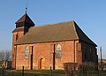
In Radowo Mały, it is worth seeing the church of Our Lady of the Scapular. It was erected in 1840 in place of the gothic one, made of granite and brick. Above the southern portal, there is a trace of the sundial in a round hole. Next to the portal, 2500-year-old Lusatian querns embedded in the walls, used as a stoup. The wooden tower from the west has not survived. The altar and the pulpit from the Middle Ages have not been preserved either. The ammonium altar was used for the statue of the Virgin Mary.
Nearest neighborhood
There are the following monuments in the commune:
1. Borkowo Wielkie - the Church of St. John the Apostle - a rectangular church, without a tower, from around 1500.
2. Czachowo - manor park, church cemetery, church (ruin) - abandoned church from the late Middle Ages, built of erratic stone, without a tower, plastered, with a separate choir, narrower than the church, 4-side closed. the oldest trees.
3. Dargomyśl - in the Middle Ages an open settlement on the Uklala River. In the years 1261-1284 the property of the Templars of Tucza, in 1398 taken over by the von Dewitz family. In the second half of the 16th century, an independent farm, still owned by the family, was developed. In the nineteenth century, it passed into the hands of the forest inspector Georg von Bulow, whose family owned significant estates in Western Pomerania. In the mid-nineteenth century, a one-story brick manor house with a porch supported by two Tuscan columns was built. The residence is surrounded by a manor park - 28 ha, with native trees in the southern part turning into a pine and beech forest.
4. Gostomin - Church of the Annunciation of the Blessed Virgin Mary - baroque church - 17th century, half-timbered, oriented, aisle, rectangular plan with a wooden tower rising from the nave on the west side. The church cemetery and the manor park - 3.80 ha.
5. Karnice - manor park - 1.12 ha. The park is dated to the 1st half of the 20th century. Nineteenth century, a romantic landscape layout with a manor house situated on a clearing planted with beech trees, chestnut trees and lime trees, fenced from the side of the road with a stone wall.
6. Maliniec - manor park - in the park with an area of about 5 ha, there are numerous old oaks (up to 5 meters in circumference), lime trees and old yew trees. Among trees of foreign origin, Canadian magnolia and fir deserve attention. About the area 5.7 ha, maintained as a romantic landscape layout with two ponds.
7. Moldavin - manor park - (13.50 ha), heavily damaged, established in the mid-nineteenth century. The assumption was based on naturalistic natural values.
Church - a parish church, the construction of which dates back to the 18th century, originally a hall structure with a tower, erected in a half-timbered structure, rebuilt in the 19th century, in 1908 the body was expanded from the west. and the tower was added (date "1908" on the weather vane). Probably as a result of these reconstructions, the half-timbered walls were replaced with brick ones.
8. Orle - a manor park with many old trees such as: linden, ash, maple, elm, chestnut avenue and some foreign trees: Caucasus fir, blue spruce (4.32 ha). It was established in the 18th century.
9. Radowo Małe Church. Our Lady of the Scapular in Radów Mały, erected in 1840 in place of the gothic one, made of granite and brick. Above the southern portal, there is a trace of the sundial in a round hole. Next to the portal, 2500-year-old Lusatian querns embedded in the walls, used as a stoup.
10. Radowo Wielkie - the NSPJ Church - already in the 15th century the village had its own temple. A document from 1491 informs about the foundation of a parish in Radów Wielki, the parish of which was Johannes Czulouwe. Originally it was a wooden structure, the fate of which is unknown. In the middle of the 17th century, the construction of a new temple was started in the place of the previous one, this time made of a more durable material - brick.
11. Radzim - palace with furnishings, manor park - 1.15 ha. The palace was built in the years 70-80. In the 19th century In the 1st quarter of the 20th century (in 1913 or 1923) - probably when the property belonged to Count Wichard von Konigsmarck - it was rebuilt. It was given a form and interior design reminiscent of Baroque and Rococo, well-preserved to this day.
12. Rekowo - in the Middle Ages a fief of the Borek family. St. Of the Apostles Peter and Paul - a 17th-century half-timbered temple on a stone foundation with a chancel closed on three sides. A wooden tower topped with a baroque dome is incorporated into the sheet metal roof (the whole was renovated in the mid-1980s).
Manor park from the second half of the Nineteenth century, expanded in the first quarter of the twentieth century (see archival maps). The assumption of the landscape type, with a linden avenue marking the southern and eastern the border and a line of spruce from the south. It is planted mainly with beech, birch, oak and chestnut trees. The boundaries of the park are clear, numerous old trees have been preserved.
Cemeteries: Churchyard - marked on archival maps, currently non-existent. The tombstones were liquidated, the area was flat, and a few centuries-old lime trees remained from the old trees. Evangelical - founded in the second half of the 19th century in the south-west from the village, by the road to Siedlice, planted along the borders with a line of spruce and surrounded by a stone wall. Currently devastated, wildly overgrown, littered, stone fence in ruins. Preserved relics of tombstones and old trees (spruces, maples, ash).
13. Rogowo - St. Michael the Archangel - built at the turn of the 17th / 18th centuries. The magnificent temple was erected on a small hill in the center of the village. Perhaps on the site of an earlier temple (it has catacombs). Inside, there is an altar with the date 1710. The present-day brick temple, dating back to the 17th century (1760s, before 1696 - the date recorded on a stone slab with the coats of arms of the von Dewitz family and the date "1696" ).
14. Siedlice - a manor park and the Church of the Immaculate Conception of the Blessed Virgin Mary - a half-timbered temple built in the 18th century, on a rectangular plan, with a chancel closed on a 5 side, with a two-storey tower partially incorporated into the nave, the baroque tower dome is topped with a pinnacle, with a ball and a cross. The date of construction of the church may be indicated by a bell from 1664, funded by Konrad von Goltze (the then owner of the property), the Bork family, the pastor and village leader.
15. Sienno Dolne - manor park - naturalistic with native trees, 1.99 ha. Established on the elevation of the area to the south of the farm yard on a quadrilateral plan with an area of 2 ha, dated to the second half of the Eighteenth century, has the features of a landscape with symmetrically planted trees (a remnant of the geometric layout of the eighteenth century), emphasizing the viewing axis from the manor house to the valley of the river. Dobrzenica and the terraced buildings on its northern shore. ABOUT
16. Sienno Górne - manor park (private property). a small 19th-century landscape complex, surrounded by a stone wall. Entrance through the facade of the manor from the south-east. linden trees were planted. The park stand consists of deciduous trees (chestnut, hornbeam, maple) as well as yew, spruce and thuja.
17. Smorawina - manor park - 0.33 ha. A small assumption dated to the 2nd half of the 19th century. In the nineteenth century, they were built to the north of the manor house and formed a cover for the manor and farm complex. Currently, it is almost illegible, a few old trees have survived.
18. Strzmiele - Church of the Blessed Virgin Mary, Mother of the Church and St. Andrew the Apostle. The present church dates from 1722. This date is preserved in the polychrome above the portal. After World War II, it was open, and from 1953 it was devastated. From 1956, the church was a sheepfold, and later a ruin. In 1992, he began to rebuild the church of Fr. prob. Wacław Pławski, on the basis of reconstruction.
At the beginning of the 13th century, there was a stronghold in Strzmiely, surrounded by ramparts. In the second half of the 13th century, Jan Borko surrounded the castle with ramparts and divided it into two parts. In the higher part, a castle was erected, probably by the descendants of Jan Borek at the beginning of the 14th century. After the Duchy of Szczecin was taken over by Barnim III, the castle was demolished around the mid-fourteenth century for insubordination of the Borek family. In 1348, the settlement was moved to a new place and received the Lübeck rights. A second castle was built in the new place. To this day, only stones from the castle walls 200 meters north of the village have remained in the place of the fortress.
After the destruction of the first castle called the Wolf's Nest, the Borek family erected a second castle on an artificial, 5-meter-high mound near the newly founded town. In 1393, the Teutonic Knights demolished this castle in retaliation for Borek's attack on the retinue of the prince of Gelderland who was going to the Teutonic state. In the 16th century, a new manor house was erected on the mound after the castle, completely eliminating the traces of the stronghold. The manor house now standing in this place has preserved fragments of the 16th-century manor. It houses a branch of the State Archives in Szczecin.
19. Wołkowo - manor park - 5.4 hectares, a park with a naturalistic appearance, established at the beginning of the 19th century. chestnut trees and making).
20. Żelmowo - Palace (private property) - situated in the center of the village, erected earlier, in 1865 it was extended - a tower and an opposite wing with a ballroom were added. In 1881 the property passed into the hands of the Schulz family and most probably Dr. Gerhard Schulz gave a new shape to the palace park in the form of two rectangles separated by a road. In the new composition, the native flora has been supplemented with over 50 species of trees and shrubs of mainly American origin. Currently private property, under renovation.
Park: landscape type foundation dated to the 1st half of the 19th century. Nineteenth century, with the palace built on a large clearing, around which red oaks, beech, walnut and elm were planted. The oval driveway in front of the palace's façade is surrounded by a row of linden trees. Oak and chestnut sashes define the boundaries of the park next to the palace and the other part on the opposite side of the street.
Monuments gallery

The historic church of Of the Immaculate Conception of the Blessed Virgin Mary in Siedlice
The church in Radowo Wielki

Church in Rekowo

Rogowo - the church

Czachowo - the ruins of the church

Radzim - the palace

Maliniec

Bumblebee manor

Strzmiele - the church

Church belfry in Radów Mały
Bumblebee manor house


![[2]](http://www.radowomale.pl/photo.php?http://www.radowomale.pl/cms_foto/20080606104912_clip_image002.gif)
work
There are a number of small trade and service companies in Radowo Mały.
Science
There is an elementary school and a junior high school here
Shopping
Local stores.
Gastronomy
Gastronomy in local agritourism farms - List - [4]
Festivals, parties
The local event is: "SYDONIA"
Accommodation
No hotel. There are agritourism centers:
- The Crane Scream Wioletta and Grzegorz Hlib
Radowo Małe 56, 72-314 Radowo Małetel. 91 57 774 57, 606 627 718
- Kajat Tadeusz
Radowo Małe 29, 72-314 Radowo Małetel. 91 39 748 55, 608 012 891
- Dobrkowski Zwierzyniec Anna and Przemysław Borowicki
Dobrkowo 8 (3.5 km from Dobra), 72-314 Radowo Małetel. 91 39 141 05
contact
Commune Office - Radowo Małe [5]Communal Cultural Center Address 72-314 Radowo Małe 5woj. West Pomeranian Voivodeship 91 561 84 24
Security
Poviat Police Headquarters - Police [6]Police station in Radów Mały - tel. 91 3972 212
Tourist information
Radowo Małe Commune Office, 72-314 Radowo Małe 21, tel. 91 397 22 22, [email protected]
Trip
A PKS bus on the route Łobez - Gryfice.