The Tel Arad National Park is an archaeological site and national park Arad in the northeast Negev.

background

The archaeological park of Tel Arad comprises two districts: the ruins of Arad from the Canaanite period and the citadel with the city from the Israelite period on the heights of the Tel.
According to the biblical report in Numbers 21,1 the Canaanite king of Arad opposed the conquest by the Israelites, according to the mention in Joshua 12,14 Arad was then subjugated by the Israelites. Also in an Egyptian inscription, the city appears in a list of places that Pharaoh Shishak found in 925 BC. was subjected to.
history


The area of the Canaanite Arad was founded in the 4th millennium BC. Founded in the Neolithic Age and developed in the Early Bronze Age (from 3000 BC) into a fortified city with a walled area of 10 hectares around a central cistern system in which the water from the urban area collected. The population lived from agriculture and animal husbandry; Due to the trade relations with the copper mines in southern Sinai, the city on the habitable edge of the desert became a trading center for copper goods. Until 2650 BC. the city remained inhabited and was then probably abandoned by the population for another 1500 years.
The settlement by the Israelites began in the 11th century. BC, in the reign of King Solomon in the second half of the 10th century. there was a small fortress with a courtyard surrounded by residential buildings. The city was fortified under the subsequent Judean kings, and a unique Judean temple complex, a water supply system, warehouses and residential buildings were excavated. Two hundred potsherds were found in the fortress. Ostraka), described partly in Hebrew and partly in Aramaic. In one inscription the "house of YHWH" is mentioned (probably with reference to the temple in Jerusalem, possibly also to the local sanctuary in Arad), in another Edom and the King of Judah, the inscription probably refers to the threat of the Judean military outpost by the Edomites.
After the destruction of the first temple, the Arad fortress was used for military purposes even under Persian rule. The ostraka, labeled in Aramaic, contain lists of provisions and military goods that were needed by the garrison in Arad. In the Hellenistic period the fortifications were expanded and the city received a central tower, in Roman times there was a fortress on Tel Arad against the threat from the south, which lost its importance after the integration of the Nabatean kingdom into the Roman Empire.
After the Arab conquest in the 7th century. a khan (caravan hostel) was built here in the area of the ruins from Roman times by a local tribe, after the destruction in the 8th century. the Tel Arad remained uninhabited. In 1962, under Ruth Amiran and Yohanan Aharoni, excavation work was carried out on Tel Arad, which continued into the 1980s.
landscape
The flat hill of Tel Arad rises only slightly above the artificially irrigated and agricultural high plateau with the modern city Arad a little further east. In the hinterland there are a number of Bedouin settlements on the edge of the hardly habitable Negev desert.
Flora and fauna
On the border with the habitable Negev desert, the vegetation is sparse.
climate
Arad with its partly Mediterranean, partly arid desert climate lies on the border of the habitable area, in the east lies the Judean desert and the Arava depression, in the south begins the Negev.
getting there
By train / bus
Out Tel Aviv if you travel by train (Israel Railways) to Beer Sheva From there there is a bus connection three to four times a day (including line 384 of the Egged) stopping at the Tel Arad Junction and further after 1 Arad bus stationArad and to the Dead Sea.
In the street
From the main street 40 from the open area Tel Aviv to Beer Sheva you bend in the Lehavim Junction on the street 31 to Arad, the road continues down into the valley of the Dead Sea. From the big city Be'er Sheva can the road 31 to Arad via the 60 can be achieved.
The driveway to Tel Arad takes place on the street 80, from the Tel Arad Junction northwards, if you are traveling without a private vehicle, you have to allow 30-45 minutes for the 2.8 km to the park entrance (or have someone take you along).
Fees / permits
Adults 15 NIS, children 7 NIS, park visit with the two-week INPA ticket included.
mobility
From the entrance building (with sanitary facilities and snack bar) an asphalt road leads up to a second parking lot at the citadel, the distances to the Israelite city with the citadel and to the Canaanite city can also be easily covered on foot. The tours in the archaeological areas can only be mastered to a very limited extent for people with walking difficulties ![]() .
.
Tourist Attractions


![]()
- A video film provides information in several languages about the history and living conditions in the city on Tel Arad, everyday scenes were reproduced in order to make the story understandable for children as well. (Ask the park staff for demonstration times).
"Lower City" (Canaanite City)
- from the parking lot leads in 2 Footpath Another footpath leads to the excavations of the Canaanite city, up to the citadel. From a shadow pavilion you can get an overview of the archaeological site.
- From a distance you can already see the large walled district, in the almost three meter high and 1200 m long city wall were originally round and square towers.
- to the right of the path through the excavation are the ruins of the 2 Holy District. Here, in a walled square, there was an altar, a round pit lined with stones, and the place was the place where cult objects were found.
- the street now climbs slightly to the west, on the left are the ruins of a large, walled complex with a central courtyard, living and storage rooms. The buildings are believed to be 3 Palace of the head of the city may have served.
- through the reconstructed western 4 City gate the tour now leaves the city for a short distance and runs outside the reconstructed city wall.
- the tour now leads through a passage in the city wall into the urban area in the residential areas in the south. A typical {{Marker | type = see | lat = 31.27826 | long = 35.12411 | name = house in the Arad style was reconstructed (and looks familiar from the information video). The buildings in Arad were rectangular, a low stone bench ran along all the walls, the roof beams across the house were supported by a central wooden post (on a stone foundation), the roof was probably covered with palm leaves or reeds.
- the path now leads down to the 5 Fountain. In the Canaanite period, the water from the rains in winter was collected in a cistern at the deepest point of the city, and canals supplied the water from all over the city during the rare rains. In the time of the Judean kings the well was deepened to a depth of 52.5 feet; The water scooped up here had to be transported up to the citadel with pack animals. In Roman times (probably under Herod in the 1st century) the well was renewed and lined with acid, several carefully plastered cisterns were built around it.
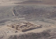
"Citadel", the upper town with the Israelite fortress
- the Israelite upper town bears witness to a resettlement of Tel Arad after a break of approx. 1500 years at the time of the kings David and Solomon, approx. in the 11th / 10th. Century B.C.
- the fortress measures 50 x 50 m and was initially surrounded by casemate walls, later with solid walls. The 6 Entrance gate was flanked by two rectangular towers. The square massive tower in the center of the citadel was not built until the Hellenistic period.
- in the northwest corner you get to one 7 temple, in which probably in the 9th / 8th Jhdt YHWH was worshiped; he is considered a small-format image of the first temple in Jerusalem. It is assumed that the temple complex was closed (but not destroyed, only covered with earth) with the cult reform under King Hezekiah (2 kings 18,4 ), the temple service was in the 8th century. henceforth concentrated exclusively in Jerusalem.
- The complex consists of a rectangular walled area. In the "sanctuary" there was a 2.2 x 2.4 m altar on the north wall, made of uncut stones, which was covered by a flint slab. Channels on the sides caught the blood of the slaughtered sacrificial animals and drained it away.
- To the west was a small room, the "Holy of Holies". Here stood a stone stele as a symbol of the divine presence, flanked by two stone incense altars (originals in the Israel Museum in Jerusalem). The stone stele was carefully put down and buried when the temple service was discontinued, which speaks in favor of a regular cessation of the sacrificial service in the temple of Tel Arad and against destruction.
- this was found in the southwest 8 "Water System", a major component of any Israelite fortress. Some of the water was collected when it rained down and was probably carried on the other hand from the well in the lower town to the citadel on pack animals and poured into a water basin west of the fortress wall, from there it flowed through a water pipe into the cisterns inside the fortress, which were carefully plastered were. The two cistern chambers with stair access are 10 m deep and had a capacity of 400 m³.
- south of the Hellenistic central tower was found in a building considered by archaeologists 9 "House of Elyashvb" "House of Elyashiv", a pottery archive with about 100 in Hebrew and 89 in Aramaic language, mostly written in ink (Ostraka), some of the "letters" were probably addressed to the commandant of the fortress, dealt with supplies and contained lists of grain and other stocks. It is unusual that an inscription was found on a pottery shard, which refers to the "House of YHWH" (בית יהוה).
activities
- Visit to the Archaeological Park
- Walks are, for example, in the area of the Yatir Forest (the 30 km² forest was afforested by the Jewish National Fund from 1964) and the judean desert possible.
- Visit of Yatir WineriesAfter the first vines were planted in 1997, they soon achieved great success in wine production.
shop
- Snacks, drinks and ice cream are available in the park administration shop
- For shopping you have to go to the nearby desert town Arad go.
kitchen
- Snacks, drinks and ice cream are available in the park administration shop
accommodation
Hotels and hostels
- the nearest hotel accommodations can be found in Arad, of Be'er Sheva Tel Arad can also be easily reached in a day trip from the resorts on the Dead Sea.
camping
- In the park area you can stay in your own tent or in a Bedouin tent, the sanitary facilities of the park administration can be used while staying overnight.
security
The security situation in the northern Negev is harmless, the access via the meanwhile expanded 31 was improved. The rental car registered in Israel cannot drive from Tel Arad on the road 80 continue to the north, after a short distance you reach the autonomous area of the "West Bank".
trips
- Visiting the Nabataean cities, for example in Mamshit
- Visit to the fortress Masada, the above Arad is easily accessible on foot from the west via the Roman siege ramp.