| ||
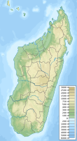
| Toamasina | ||
| province | Toamasina | |
|---|---|---|
| Residents | 225.116 (2010) | |
| height | 6 m | |
| no tourist info on Wikidata: | ||
| location | ||
| ||
Toamasina is a city on the east coast of Madagascar. With over 280,000 inhabitants, it is the third largest city in the country. It was ruled by different rulers over the years. The Portuguese were followed by the French, then came the British, followed by the tribe of the MerinaThen came the French again, who gave the city its name Tamatave gifts. The colonial powers are now a thing of the past and the city is officially called again Toamasina.
background
Toamasina is the only city on the east coast of the island that has a natural harbor. It was created by a coral reef that once protected slave traders and pirates. In the meantime it has developed into the most important trading port in the country.
The runs along the east coast Canal des Pangalanes, a waterway built in colonial times. It starts at Toamasina and ends after 645 km at Farafangana.
getting there

By plane
- 1 Toamasina Airport (Ambatovy Airport, IATA: TMM)

 in the Wikidata database")
By train
There is a single-track railway line to the capital Antananarivo
By bus
In the street
By boat
The 2 port is occasionally the destination of cruise ships en route to / from the Seychelles.
mobility
Tourist Attractions
- 1 Notre Dame de Lourdes (Fiangonana Notre Dame de Lourdes), Rue De Farafaty, Toamasina, Madagascar. cath. Church.
- 2 Fort Manda (Foulpointe, Madagascar)
activities
shop
- 1 Bazary Be Market