Tourist Drive 33 is a major tourist drive from Calga to Branxton, the second longest tourist drive in New South Wales and also the second most promoted tourist drive in New South Wales after the Grand Pacific Drive.
Understand
No other place of Australia has long interior tourist routes as well situated as this one - with either the views, the access, the wineries, the length and variety of environments or its historical significance. To travel from either Gosford or Hornsby along this route, even only in sections if restricted by time or budget, is an experience that has an impact on most travellers.
It's also where Glenworth Valley and the Hunter Valley Gardens are situated, making it one of the most used tourist drives in Australia along with the Grand Pacific Drive or Great Ocean Road (B100).

History
Parts of this route were built by convicts in the early 1800s to connect Sydney to the Hunter Valley. Construction of the Great North Road began in 1826. It was considered one of the greatest engineering records for the early 19th century.
The Great North Road is 240 km long, and parts of it are part of Tourist Drive 33. Most of the road is used today as an alternate way to get to the Hunter Valley, and is also the scenic route.
Much of the 240 km of the Great North Road has been renamed, such as to Wisemans Ferry Road, Old Northern Road or Old Great Northern Road; however, the original name is still used on the section between Mogo Creek and Wollombi. Meanwhile in Sydney, the Great North Road in Five Dock/Abbotsleigh was also once part of the same road.
The Great North Road was not a continuous road for 240 km. Occasionally, there were ferries and parts of it was split. To this day, some parts of the road are not connected and there are some ferry crossings (e.g. Wisemans).
Regardless, the road was an iconic architecture and engineering feat for the 19th century. Some parts are scenic, too. The sandstone formations, which can still be seen in some parts, are an icon of the drive.

The modern-day Great North Walk had also origins from this route. The 200-km Sydney to Newcastle road passes through some of this route — mainly the route of the Great North Road.
Prepare
There are parts of the drive that have no mobile signal. You will most likely need to carry a satellite phone. It can get mildly windy in parts, especially in those on the higher altitudes of Mangrove Mountains. In some areas, especially in Glenworth Valley, there are so much flies that you will almost certainly want to carry an insect repellent.
The next question is if you want to drive the whole way on the road, or stop and enjoy a kayak or horse ride at Glenworth Valley or see some flora and fauna at Hunter Valley Gardens. This will almost certainly come down to time. A simple trip along the road can be quite time consuming. For example, from the Hornsby city centre to the Hunter Valley Gardens can take up to 3 hours on the road non stop. There are other direct routes you can take to get you there faster without going on the winding scenic road like the M1 Pacific Motorway on the east and the M15 Hunter Expressway to the north.
You can do the road in a long day starting quite early from Hornsby and finishing the loop back quite late. If you do so, make sure you are road tripping with someone, or a group of you who can share the driving. There are also options in staying in one of the villages or Glenworth Valley, Peats Ridge, Wollombi or the Hunter Valley along the road and breaking the trip in multiple days.
Climate
The climate of most of the drive varies from very hot to somewhat cool. In summer, the weather can get to a scorching 40˚C, while in winter temperatures can get very cold compared to the rest of New South Wales and drop to 12˚C. There is also has a wet spring season when the drive can be slick. Autumn is usually the milder, dry season, bringing 30°C highs, blue skies and the bulk of tourists.
Snow can be a problem in Wollombi in the winter, however snow is very rare and only occurs 1 in every 10 years. However, it is always a good idea to check the weather and forecast before going as rain can also affect the journey.
Phone coverage
Payphones
Payphones are scattered throughout the drive, but some on the street side in some towns suffer from vandalism and may be inoperable. It might be best to try the one at your hostel or at the tourist centre. Phones are coin-operated or use prepaid phonecards, available from most supermarkets or newsagents. International calling cards are also available at these outlets.
There are also emergency phones on the drive, approximately every 10-20 km.
Mobile phone signal
Mobile phone coverage can be sketchy. The Telstra networks have a good signal within town, becoming variable to non-existent especially on the Mangrove Mountains to Wollombi. Other networks like Optus and Vodafone are hit and miss, but those with 3G/NextG phones might have more luck.
If you intend to spend any amount between Mangrove Mountains and Wollombi or go on one of the side routes of the drive, it is very advisable to rent a satellite phone to call for emergency services should anything happen.
Spare some change? Some places won't have a card reader. There are also very few ATMs along the way; however, they can be found in either Wollombi, Cessnock or Branxton |
Biking
While cycling is possible, it is recommended only for those that can endure long rides while carrying camping and survival equipment. Spare at least 4 days if you wish to bike all the way.
During high winds there are few shelters where one can rest and no trees to at least block some of the wind. There are no separation of lanes between bicycles and cars, ride with care and provide right of way to whoever is driving faster. Helmets must be worn and headlights must be on at all times. Make sure to have all the necessary equipment in optimal condition throughout the journey, as the nearest repair shop can will either only be in Cessnock or Wollombi.
If you wish to take a break and take the bus instead, you may not. Buses do not operate on most of the drive and where buses do run; bikes may not be carried onto buses, although this is at the driver's discretion.
Bus
Only 15% of the drive is covered by bus. And the service does not stop along but a route for people to travel for other purposes; ie not a scenic run through the drive.
Get in
There are multiple starting points, depending on where you wish to begin the journey.
There are 3 commonly used entries on Tourist Drive 33. One is down south on the M1, the second one is the B82/B68 entry at Cessnock and the third one is at the M15 near Branxston, the very north of the drive. There are other entries too but these three are the most common ones. Once your in, just follow the Brown Tourist Drive 33 signs.

Get around
By car
This drive can be easily achieved as long as you have a car. Distances are long, steep and without a car, it is virtually impossible to accomplish.
By bus
Buses only operate from Cessnock to Branxton for non tourism purposes only.
By train
There are no trains that run parallel to this route and trains only stop at Branxton and Cessnock but they aren't a direct line.
Go
Many visitors will wonder how much there is to see in such a short drive. The answer really depends on your interest.
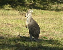
Sunset and sunrise are the best times to get out and look. Not only are the temperatures cooler, but the quality of light ignites the stone with a luminous orange tone. You're also more likely to see animals that have been hiding from the midday heat venturing out to feed and all the pesty insects would not be here, early in the morning. Not only that but you also see a nice beautiful sunrise and sunset, up on the mountains. Some side routes are not possible to access if you do not have an SUV.
Hornsby to Calga
Speed limit: 110 km/h
Although, this part of the journey is not part of the official gazetted Tourist Drive 33, the journey to Calga is a nice, picturesque drive, passing the Hawkesbury River; a great camping spot or a place to explore for a day. While most people who use this drive use the M1 Pacific Motorway, you can also use the B83 Pacific Highway; a more scenic route and a route for those who want to avoid 110 km/h high speed roads.
Calga to Glenworth Valley
Speed Limit: 100 km/h (40 km/h on Cooks Road)
- Distance: 3 km (plus a 3-km-long drive to get to Glenworth Valley Outdoor Adventures)
- Road surface: asphalt (gravel for 1 km of the 3-km-long route to get to Glenworth Valley Outdoor Adventures)
- Roads taken Peats Ridge Road (and Cooks/Popran Road to get to Glenworth Valley Outdoor Adventures)
You do not have to go to Glenworth Valley, however most tourists go to Glenworth Valley and camp for a night or two as well as do some of the outdoor adventures out there.
As of Feb 2021, there are no plans to pave the 1 km of unpaved road as the road is not owned by the NSW government, so it is very advisable to not go in a sedan or any vehicle that is not a 4WD or a caravan.
There may also be potholes on Cooks Road so again, it is very advisable to go in either a 4WD or a caravan.
However, on Peats Ridge Road, the road is fairly straight with little bends and sharp bends or hairpins.

Along the way; you can stop and do the following:
- 1 Glenworth Valley Horse Riding (Glenworth Valley Outdoor Adventures), Cooks Rd, Glenworth Valley, ☏ 61 2 4375 1222. Daily 8:30AM–5PM, bookings required. Closed on public holidays. Minimum $80.
- 2 Glenworth Valley Kayaking (Glenworth Valley Outdoor Adventures), Popran Rd, Glenworth Valley, ☏ 61 2 4375 1222. Daily 9AM-5:30PM, bookings required. Closed on public holidays.
You can eat or have a coffee at the 1 Glenworth Valley. cafe.
Glenworth Valley to Bucketty
Speed limit: 60-100 km/h
- Distance: 41.3 km
- Road surface: asphalt
- Roads taken Peats Ridge Road and George Downes Drive
The road is a narrow two lane road with only one lane paved on George Downes Drive. Parts on Peats Ridge have 2 lanes. On George Downs Drive there may be a double lane marker, but it is just a guide for other vehicles passing in the opposite direction. If there is a vehicle coming on the opposite direction; you are expected to go slightly off the paved road to let the oncoming vehicle pass by. After the oncoming vehicle has passed, there may be some dust which can block vision. Also avoid overtaking vehicles on sharp bends, black spots and hairpins.
Along the way, it is also home to 1 Kulnura One Stop Jerry's Cafe. one of the most famous cafes in the region. If you are stuck in this area, the nearest supermarket will most likely be the 1 Kulnura General Store. on Greta Road.
Additionally, for those who brave the heights, take Brieses Road and Old Mooney Dam trail and explore the 1 Mooney Mooney Dam., and for those who enjoy a nice picnic at the lake, there is the same opportunity except the fact it is the 2 Mangrove Creek Dam Picnic Area. which requires a 12.8-km drive from Kulnura, the nearest town. Avoid using this route unless you are going on a 4WD. The road may also be closed during rain or storm.
Bucketty to Wollombi
Speed limit: 60-80 km/h

- Distance:
- Road surface: asphalt
- Roads taken Great North Road
The 19th-century road built by convicts merges here. It is still a narrow two-lane road. However, the road here is not suitable for caravans and large vehicles. You can also drive take a side route and drive across the 1 Great Northern Road. towards 2 Wisemans Ferry. and 3 St. Albans..
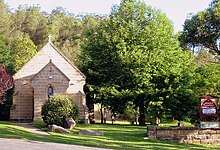
In Wollombi, you can also explore the 2 Ngurra Bu.; one of the historic and culturally significant Aboriginal sites. Not to worry; if you are the person who'd like to see historic churches 3 St Michael the Archangel's Wollombi Church. is a really historic, well preserved church built back when the town was founded.
Wollombi to Cessnock
- Distance: 31.1 km
- Road surface: asphalt
- Roads taken Wollombi Road
The road starts to widen as this is the primary route to Wollombi for freight. Both lanes are paved. Wollombi to Cessnock is also one of only 3 ways to get out or into Wollombi. This part of the drive also passes 4 Millfield. ![]()
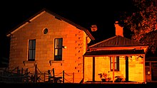
![]() ; Millfield. has a general store and the historic Rising Sun Inn, which now operates as a museum.
; Millfield. has a general store and the historic Rising Sun Inn, which now operates as a museum.

Cessnock to Branxton
Speed limit: 100 km/h
- Distance: 20.5 km
- Road surface: asphalt
- Roads taken B82 Wine Country Drive,
Although this route is no longer signed at Branxton, the journey through this part is an amazing experience. Passing through this route from Lovedale to Cessnock is an unforgettable experience that most wine tasters will enjoy. Along the way is also home to one of the Hunter Valley's most famous zoo's here; the 4 Hunter Valley Zoo, 138 Lomas Ln, Nulkaba, ☏ 612 4990 7714. Thursday-Tuesday 9AM-4PM. ![]()
![]() is also a good place to visit.
is also a good place to visit.
Alternate Tourist Drive 33 (Wollombi to Lovedale via Broke and Pokolbin)
Speed limit: 20-100 km/h
- Road surface: asphalt
- Roads taken
This is the alternate route for those willing to go and see Pokolbin, home of the 5 Hunter Valley Gardens, 2090 Broke Rd, Pokolbin, ☏ 61 2 4998 4000. 9AM-5PM.. Pokolbin is also home to some of the best wineries in New South Wales; hence the attraction for many.
The road may be narrow at certain parts of the road. If a large oncoming vehicle comes, slow down to 40 km/h however, do not follow the protocols where there are only one lane paved. Always stay on the road whenever possible.
Along the way is also home to the 2 Hunter Jewellery School., which isn't really a school but a jewellery shop for those keen.
For those who like to go to the bar, at Broke, there is also a famous wine shop called 2 1813. and for those who like a wine with food, 3 Nightingale Wines & Restaurant. and 4 Margan Wines & Restaurant. which all three shops sell local wine.
Furthermore, for those who like history and wine, 6 Hermitage Road Cellars, Winery and Hunter Wine Theatre @ Hunter Valley Resort. is the place to go.
But for those who have little or no interest in wines and wineries, go on a segway at 3 NSW Segway Tours. or go on 4 Hot-air ballooning, 1/26 Lodge Rd, Lovedale NSW 2325, toll-free: 1800 028 568. at Hunter Valley Hot Air Ballooning.
While most NSW road speeds are too low, this one's a bit different. The nominal speed limit is 100 km/h, driving at that speed is dangerous given the road conditions, and most people keep to 80 km/h, less in the bends and the officially recommended speed on bends is 75 km/h, which is considerably safer but still too high.
Other tracks
- Big Yango Loop Trail - A 4WD track that explores parts of Yengo National Park.
- The Wattagans - Another track for serious 4WD tracks to explore the Watagans National Park.
- Howes Valley Trail/Finchley Track - One of the scenic 4WD trails. A must do when visiting Yengo National Park. Also a must for any motorbikers or mountain bikers.
Drive
TD33
- 1 Calga. Start your journey (if you're going north) here. Finish your journey (if you're coming south).


- 2 Glenworth Valley. Drop in for a horse ride or play the world's first outdoor laser tag.
- 3 Peats Ridge. Camp a day or two here.
- 4 Mangrove Mountain. Where the Central Coast's water comes from.
- 5 Kulnura. Pop out for a bush walk.
- 6 Laguna. Explore some of the scenic spots on the mountains. Home to the most lookouts on the drive. And there is no lagoon on the way, sorry.
- 7 Wollombi. Camp a night or two here on one of the historic convict built sites.
- 8 Millfield. Taste a bit of locally made wine (if you're over 18).
- 9 Cessnock. Check out some of the wineries here.
- 10 Lovedale. Explore even more wineries or check out the Hunter Valley Zoo.
- 11 Branxton. Finish your journey (if you're driving south) here. Start your journey (if you're driving south). Also explore some wineries.
Alternate TD33
- 12 Calga. Start your journey (if you're going north) here. Finish your journey (if you're coming south).
- 13 Glenworth Valley. Drop in for a horse ride or play the world's first outdoor laser tag.
- 14 Peats Ridge. Camp a day or two here.
- 15 Mangrove Mountain. Where the Central Coast's water comes from.
- 16 Kulnura. Pop out for a bush walk.
- 17 Laguna. Explore some of the scenic spots on the mountains. Home to the most lookouts on the drive. And there is no lagoon on the way, sorry.
- 18 Wollombi. Camp a night or two here on one of the historic convict built sites.
- Broke. Taste a bit of locally made wine (if you're over 18).
- Pokolbin. Check out some of the wineries here.
- 19 Lovedale. Explore even more wineries or check out the Hunter Valley Zoo.
- 20 Branxton. Finish your journey (if you're driving south) here. Start your journey (if you're driving south). Also explore some wineries.
Stay safe
All of the road is paved. Just watch out for the wildlife on the road. The Telstra networks have a good signal within town, becoming variable to non-existent especially on the Mangrove Mountains to Wollombi. Other networks like Optus and Vodafone are hit and miss, but those with 3G/NextG phones might have more luck; bring a satellite phone with you.
Some part of the road have only one lane paved, right down the middle. When approaching another car both of you are expected to move left off the bitumen onto the dirt at the side of the road, pass, and then move back onto the black. Be wary immediately after passing, as the other car will have stirred up a huge dust cloud which will lower visibility for several seconds.
Fill up whenever you can, especially if you choose to go through the side routes or the Mangrove Mountains. Firstly, there's no guarantee that the next fuel station has fuel available, moreover the mountainous terrain means higher fuel consumption than you might expect.
All of the route is single carriageway with a 100 km/h speed limit. Do not be tempted to speed - the police have the route well-covered and there are plenty of static cameras. When passing through towns en route, it is necessary to slow down to as little as 40 km/h.
Road closures
Respect road closures, even if the road or track appears traffic-able. The road may have been closed due to being damaged or impassable much further down the road. If you proceed you may end up having to turn back or become stranded at a remote location where you shouldn't expect your cell phone to work or anybody to pass soon. Instead, just find as comfortable a place as possible and wait for the conditions to improve and for the road to re-open, or come again another day if available. Roads are sometimes closed to prevent them becoming seriously damaged by vehicles transiting them when the surface is too soft or slippery after rain. Do not be an irresponsible person by causing damage to a road by continuing your journey.
Go next
- Continue north and explore Tourist Drive 2/The Bucketts Way
- Go to the Central Coast and explore some of the beaches or drive the Scenic Highway.