![]() Click here to see the map of the area in full screen.
Click here to see the map of the area in full screen.

The Auckland (English: Auckland), in the North Island of New Zealand, is the largest urban area in New Zealand.
At a glance
Ideal period of visit
How to get there
 By air
Auckland International Airport. (IATA: AKL). New Zealand's largest airport, located next to Manukau Harbor, in the southern suburb of Manger. It is a major base for New Zealand Airlines (Air New Zealand)
 By train
 By road
 By boat
 Bus
Bus
Britomart Station (Britomart Transport Center), 8-10 Queen Street. The main transport hub of the city. It is the end of the Wellington / Auckland Railway
Apartments

| Centre The main apartment (Central Auckland) is located on an isthmus that separates Hawraki Bay from the port of Manukaou, which opens into the Tasman Sea. |
| North Port The North Port (North Harbor) is enclosed by the Port of Waitemata to the south and the Rangitoto Canal of Hauraki Bay to the east. Auckland Harbor Bridge connects it to the city center. The North Port is made up of the suburbs of Devonport and Albany. The first is home to the Royal Navy's New Zealand Naval Base and the second is home to the University of Massé Ώ Auckland campus. The Albany area has grown significantly over the last five years. The once quiet rural suburb has become the shopping center of the North Port. |
| South Auckland South Auckland (South Auckland) consists of the suburbs of Manukaou, Houik and Papakura. Manoukaou is considered an extension of the center as there are no clear divisions between Manoukaou and the rest of the city. Auckland International Airport is located in Mangere, west of Manukau, near the waters of Manukau Harbor. South Auckland is ethnically diverse, home to many cultures, especially Maori and members of Polynesian ethnic groups, with a recent influx of Asians in and near Howick. It is the most densely populated apartment in the city. |
| West Auckland West Auckland (Former City of Whitaker, Waitakere City) stretches in the forested Whitehake Mountains that rise sharply from the shore of the Tasman Sea to an altitude of over 400 meters. |
How to move
By road
Bus
Subway
 Tram
Tram
 By foot
 Bike
Bike
What to see
- Gallery (Auckland Art Gallery), Kitchener over Wellesley, ☎ 64 9 307 7700. Daily from 10am to 5pm. Free entrance.
- Auckland Museum (Auckland War Memorial Museum), Auckland Domain, Parnell, ☎ 64 9 309-0443. Daily from 10am to 5pm. $25.
- Zoo (Auckland Zoo), Motions Rd, Western Springs, ☎ 64 9 360-3800, e-mail: [email protected].
- "Kelly Tarlton" seawater aquarium (Kelly Tarlton's Sea Life Aquarium), 23 Tamaki Drive, Orakei (bus lines 740–769).
- Museum of Transport and Technology (Museum of Transport and Technology), Great North Rd, Western Springs (near the zoo). Daily from 10am to 5pm. $16.
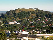
- Mount Eden (Mt Eden or Maungawhau), 250 Mt Eden Road (Car Entrance). The summit of Mount Eden offers probably the best view of Auckland
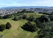
- One Tri Hill (One Tree Hill Maungakiekie), 670 Manukau Rd (Main entrance). volcanic cone dominating the horizon in the southern inner suburbs.
- Sky Tower (Sky Tower), Victoria Street along Federal St. the tallest unsupported structure in the Southern Hemisphere, at 328 meters.
- Planetarium (Stardome Observatory & Planetarium), 670 Manukau Road, One Tree Hill Domain.
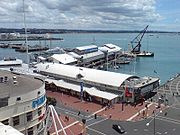
- Marine Museum (Voyager New Zealand Maritime Museum), ☎ 64 9 373 0800. Daily from 9am to 5pm. $17.
- Gallery
Marine Museum
One Tri Hill

Gallery
.jpg/182px-The_Auckland_War_Memorial_Museum_(2730788919).jpg)

Main entrance to the zoo
Mount Eden

Kelly Tarlton Aquarium


.jpg/182px-The_Auckland_War_Memorial_Museum_(2730788919).jpg)


Entertainment
What will you buy
Studies
Job opportunities in Auckland
Which area to go for coffee - drink
Local drinks
Which area to go for food
Local cuisine
In what area to stay
Stay safe
 Honorary Consulate of Greece, 108 Paihia Rd, One Tree Hill, ☎ 64 9 571-0238, fax: 64 9 571 0529, e-mail: [email protected]. 9 am-4pm.
Health and precautions
Communications
Next destinations
![]()