![]() Click here to see the map of the area in full screen.
Click here to see the map of the area in full screen.

The Gravia, Kastellia, Mariolata, Vargiani, Apostolias are its settlements Φωκίδας in Roumeli, in Central Greece.
Generally
THE Gravia is built at an altitude of 400 meters northeast of the prefecture of Fokida, at the foot of Mount Parnassos. Its population according to the 2011 census is 604 inhabitants.
The Castellia have a population of 523 inhabitants. It is located on the road axis Lamia - Amfissa - Nafpaktos and is about 40 km from Ghoul and 35 mm from Amfissa. They are built at the foot of Giona and Oiti and in front of it stretches the basin of Boeotian Kifissos or Doric valley as it is commonly called.
THE Mariolata is built at an altitude of 380m. at the foot of Mount Parnassos and has a real population of 368 inhabitants, according to the 2011 census. holy women. They learned their secrets and told them to messengers and they in turn told them to the fortune teller Pythia, so that she knew everything about them! It is divided into two settlements, the old and the new. Mariolata is narrow and long with a wide horizon. Its picturesque locations "Goura" and "Drambala" with cool springs attract many vacationers. Climbers and hunters visit the village in winter and spring. The inhabitants are engaged in the cultivation of cereals, legumes and vines. High on the hill are the ruins of the Doric city of Vion which was destroyed by the Persians in 480 BC. as well as the Bartospilia that was built during the '21 gunpowder revolution. Also noteworthy is the gorge that leads to Bartospilia. It celebrates on September 8, the great feast of the Nativity of the Virgin.
THE Vargian is a village at an altitude of 890 meters and has a population of 38 inhabitants. The village is known for the great battle (September 14, 1824) which ended with the victory of the Greeks and the defeat of the Turks. It celebrates on July 26, Agia Paraskevi in the cathedral of the same name. Today it is a traditional settlement with stone constructions. Attraction of the area is the Fairy Cave with stalactites and stalagmites, in the middle of a rock south of the village. At the point leads a path on the rock.
THE Mission (formerly lower Kaniani) is located at the foot of Oiti northwest of Gravia and at an altitude of 520m. The settlement was created around 1830. It was developed with the arrival of many inhabitants from different areas, such as e.g. from Epirus (Souli area). Before World War II, most of the inhabitants worked in the bauxite mines that covered the eastern side of the "Agios Vassilios" mountain range. Their support facilities were inside the village (engine room). From the village (location Parliouria) to the top of the mountain, on the slope "Amalia" there was an installation of an aerial wagon that transported the ore, from the top to Paliouria. Even today, the signs from the route of the aerial wagon have remained clear. Due to the ore residue falling from the aerial wagons during transport. Today, the village is inhabited -mainly- by the elderly, and very few by young people.
History
Tourist sites
How to get there
 By road
How to move
What to see

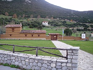
- Hani of Gravia. on May 8, 1821, the famous battle took place. In honor of the victory of Odysseus Androutsos in the battle of Hani, every year events are organized on this day.
Entertainment
Events
What will you buy
In Gravia and the surrounding areas you can buy various traditional products, mainly locally produced.
Where to go for coffee - drink
Gravia has several traditional cafes where you can go for coffee or a drink.
Where are you going to eat?
Where will you stay?
Stay safe
Health and precautions
Communications
Small problems
Next destinations
![]()