

Northern Cape lie inSouth AfricaThe northwest corner of the city. Although it is the largest of the nine provinces (361,000 square kilometers), its population is very small (about 900,000 people).
area
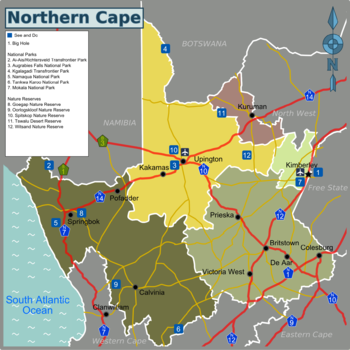
Northern Cape can be divided into the following areas:
| Diamond region Eastern Frontier of Northern Cape |
| Karoo Southeast Region |
| Namakwa West Coast andWestern Capeborder |
| Green Kalahari Located in the north, withNamibiawithBotswanaborder |
| Kalahari North-east area |
city
Other destinations
National Park
- 1 Ess-Richardsveld Transboundary National Park

- 2 Augrabies Falls National Park
- 3 Kagra Gedi Trans-Border Park
- 4 Namaqua National Park
- Takawa Karoo National Park
- Mokara National Park -The newest park in South Africa, replacing the old Valbos National Park.
Other nature reserves
learn
Originally the Northern Cape was part of what was previously known as the Cape Province. However, after the 1994 elections, the old provincial boundaries were re-divided, and Cape Province was divided into Northern Cape,Western CapewithEastern CapeProvince.
The Northern Cape is a dry and sparsely populated area, most of which is desert. Nevertheless, the local area has its own beauty and is a popular destination for South African and foreign tourists.
Language
arrival
drive
There are many good national roads in the Northern Cape.
- N1 FromCape TownarriveHowdenPast the southeastern edge of the Northern Cape andBloemfontein。
- N7 From Cape Town andWestern CapeStart, go throughSpringbok, Then go northNamibia。
- N8 Passing near UpingtonKimberleywithBloemfontein, And then continue toMaseruBridge (boundary toLesothoMaseru)。
- N10 FromNamibiaBorder downUpingtonAnd then toEastern CapePort Elizabeth。
- N12 FromWestern CapeofGeorgeTo Gauteng, pass by Kimberley.
- N14 FromSpringbokTo Wupingtong, then to GautengJohannesburgwithPretoria。
aviation
Upington AirportwithKimberley AirportThere are flights to some major cities in South Africa, fromSouth African AirwaysOperating.
Domestic traffic
Local public transportation is limited, so your best option is to drive. Please remember to refuel first, as the distance to the local gas station may be very long.
go sightseeing
- A historic diamond mining townKimberley, With world-famousDashuitanAnd many other attractions.
- existBotswanaBorderKagra Gedi Trans-Border Park