
24°55′12″N 102°28′12″E
Anning mapAnning,Yunnan ProvinceKunming CityThe hosted county-level city is located on the eastern edge of the Central Yunnan Plateau, with a total area of 1,313 square kilometers, a distance fromKunming32 kilometers. The northeast of the city is connected with the Xishan District, and the southeast is connected withJinning DistrictBorders, west andEasy door、LufengAdjacent to the county. The population is 357,000.
Anning has superior geography and well-developed transportation. National Highway 320 leads directly to Myanmar, Kun'an, Anchu Expressway, and Chengdu-Kunming Railway pass through the border. Construction of Anjin Expressway and Kunguang Railway double line has started.
arrive
Aviation 
Railroad 
Bus 
Traffic in the prefecture
Attractions

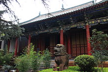
Jogyesa Temple
Anning Confucian Temple

Wang Renqiu Monument

Reclining Buddha at Fahua Temple in Anning
- Jogyesa Temple。IntroductionNational key units
- Anning Confucian Temple。IntroductionNational key units
- Wang Renqiu Monument。IntroductionNational key units
- Fahua Temple Grottoes。IntroductionYunnan Provincial Cultural Relics Protection Unit
- Hot Spring Cliff Rock Group。IntroductionYunnan Provincial Cultural Relics Protection Unit
- Eight Street Confucian Temple Complex。IntroductionYunnan Provincial Cultural Relics Protection Unit
Shopping
Dining
stay
Safety
 | Emergency phone number: police:110 ambulance:120 Fire brigade:119 |
Medical treatment
Hospital 
- Anning People's Hospital。
- Anning Traditional Chinese Medicine Hospital。