.svg/250px-Nepal_(orthographic_projection).svg.png) | |
| capital | Kathmandu |
| currency | Nepalese Rupee (NPR) 1 NPR = 0.0092 USD |
| population | 30,327,877(2020) |
| Power Systems | 230 Volts / 50 Hz (European plugs, AC power plugs and sockets: British and related types, BS 546) |
| country code | 977 |
| Time zone | UTC 05:45, Nepal Standard Time |
| Language | Nepali |
| Emergency call | 100 (police agency), 101 (fire department), 102 (emergency medical service) |
| Driving direction | Left |
| Edit on Wikidata | |

Nepal, Is a mountainous landlocked country in South Asia, located in the Himalayas, withChinaTibetThe autonomous region is connected, and the other three sides are connected withIndiaFor neighbors. Of the ten highest peaks in the world, eight are in Nepal, including the Sagarmatha Peak (that is, theMount Everest) Is the highest mountain in the world. There is also Lumbini, the birthplace of Buddha Sakyamuni in the territory. The Nepal National Assembly announced the abolition of the monarchy on May 28, 2008, ending the 240-year Shah dynasty, establishing the Federal Democratic Republic of Nepal, and realizing the republic.
learn
geography
Nepal has a large altitude and climate span, from the Terai (Tera River, "Popular Chinese translation, not officially recognized") area, which is located at the northern edge of the Ganges Plain with an elevation of less than 100 meters (328 feet) and has subtropical climate characteristics, to Including Mount Everest, there are more than 90 peaks over 7000 meters (22,966 feet) above the permanent snow line.
history
people
climate
festival
area
Nepal is officially divided into 14 administrative regions and 5 development regions, but travelers may prefer the following regional division (based on the country's altitude). From north to south:

| Himalayas The roof of the world, includingMount Everest、Annapurna、Blue Tang National ParkandGreat Himalaya Trail, There are countless opportunities for sightseeing, hiking and other adventure sports. |
| Kathmandu River Valley here isKathmandu、Buhanat、BatanandBohatapurThe place, located in the heart of Nepal, is a crossroads of cultures, with many sacred temples and monuments. |
| Central Mountain The altitude of the central mountainous area (Pahar in Nepali) is mostly between 700 and 4000 meters. This area is separated from the Tailai Mountains by the Mahabharata (Little Himalayas), forming a geographical central zone between the Tailai Mountains and the Himalayas. It includes the scenic Pohara Valley, which is the highlight of the area. |
| Sidray West Terai has Chiwan National Park and Badia National Park. |
| East Terai This is Nepal's second largest city and a densely populated area. |
city
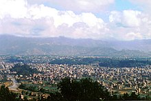
- Kathmandu — The capital and cultural center of Nepal, its Kathmandu Palace Square and stupa are inBudanatandSwayambunat
- Bhaktapur — Well-preserved historical cities, pilgrimage centers and Nepal pottery making centers, no motor vehicles are allowed to enter
- Biradnagar — An important agricultural and political center near Dhahran in eastern Nepal
- Birganj — The business gateway between India and Nepal
- Janakpur — This is a historical religious center and the site of the 500-year-old Janaki Temple
- Nanqi Bazaar — Sherpa settled in the Sorukumbu area, popular with hikers
- Nepalganj — The main force in the development of the central and western regions, Badia National Park is nearby
- Patan — In 1979, the beautiful and historic Batandbar Square was listed as a World Heritage Site by UNESCO
- Pokhara —The picturesque lakeside town has quickly become the preferred destination of tourists due to its virginally pure scenery, adventurous sports, dining, hotels and live music, etc.