_(Polynesia_centered).svg/250px-Samoa_on_the_globe_(small_islands_magnified)_(Polynesia_centered).svg.png) | |
| capital | Apia |
| currency | Samoa Tara (WST) |
| population | 196,440(2017) |
| Power Systems | 230 volts / 50 Hz (AS/NZS 3112) |
| country code | 685 |
| Time zone | UTC 13:00 |
| Language | English, Samoan |
| Emergency call | 999, 994 (fire department), 995 (police agency), 996 (emergency medical service) |
| Driving direction | right left |
| Edit on Wikidata | |
Independent State of SamoaAbbreviationSamoa, Is an island country in the South Pacific, approximately located inHawaiiandnew Zealandin the middle,American SamoaTo the west, it is the center of the Polynesian Islands. Independence in 1962.
learn
history
In 1000 BC, Samoa had been settled. After the Second Samoan Civil War, Samoa was divided into two. The east was ruled by the United States and became the present American Samoa, while the west became a German colony in 1899. The First World War had just begun. In August 1914, New Zealand occupied German Samoa to prevent Germany from using it as a naval base in the Pacific. The German troops on the island did not surrender, but they did not resist either. In 1919, in accordance with the Treaty of Versailles, Germany ceded Western Samoa to New Zealand.
New Zealand managed Western Samoa under the name of the League of Nations and the United Nations until its independence on January 1, 1962. Western Samoa was the first island nation of Polynesia to become independent in the 20th century.
On March 31, 2006, Samoa’s parliamentary elections were held. The ruling Human Rights Protection Party won the general election again, winning 30 of the 49 seats in the parliament. It became independent in 1962 and was called "Western Samoa"; in 1997, it was renamed "Samoa".
With the increase in the number of Samoans moving and emigrating to Australia and New Zealand, Samoa changed the direction of road traffic on September 7, 2009, from driving on the right to driving on the left, in order to facilitate the import of cars. On the evening of December 29, 2011, Samoa changed its standard time from UTC-11 to UTC 13 (daylight saving time was changed from UTC-10 to UTC 14) in order to eliminate business barriers due to the one-day difference with Australia and New Zealand.
geography
Samoa is an island country in the South Pacific, located approximately between Hawaii and New Zealand, to the west of American Samoa. The land area is 2,831 square kilometers. The islands are undulating and volcanic. The highest peak of Savai’i, Mauga Silisili, is 1,858 meters above sea level. It belongs to a tropical rain forest climate. The rainy season is from November to April of the following year, and the annual precipitation is more than 2500 mm. The southeast trade wind blows, and the annual average temperature is about 29 degrees Celsius.
area
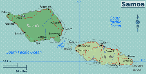
| Upolu i. The capital is located, with an international airport and most of the population, as well as several small islands |
| Savai i. The largest island; about 24% of the population and less developed than Upolu Island. Most services can be found in Salello Loga and the resort |
city
- Apia -There are a few good restaurants, a leisurely capital town. As well as good shopping shops, restaurants, bars and public markets.