| Tajmyr district | |
 | |
Location 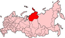 | |
Coat of arms and flag  | |
| State | Russia |
|---|---|
| Region | Siberia |
| Capital | Dudinka |
| Surface | 879,900 km² |
| Inhabitants | 33.861 (2014 census) |
| Institutional website | |
Tajmyr district is a region of Russia today included in the Krasnoyarsk Territory.
To know
Geographical notes
The Tajmyr district or Dolgano-Nenec district (in Russian: Долгаяно-Ненеяцкий автоноломный олокруг), is a district (okrug) of Russia, which is part of the Krasnoyarsk Krai of which it forms the northern part. The capital is Dudinka while the largest center is Noril'sk, the second city in the world by population (after Murmansk) within the Arctic Circle. The district overlooks the Kara Sea to the north and the Laptev Sea to the north-east. It borders to the east with the republic of Sacha-Yakutia, to the south with the district of Evenk and the Krasnoyarsk kraj and to the west with the autonomous district of Jamalo-Nenec. The district takes its name from the Tajmyr peninsula which forms the northernmost continental part. The archipelagos of Severnaja Zemlja, Nordenskiöld, Kirov and other islands located in the Arctic Ocean are part of the district. The territory is mountainous to the north, in the Tajmyr peninsula, where the Byrranga mountains rise, reaching a maximum height of 1,148 meters, while to the south rises the Putorana plateau, which reaches 1,701 meters. In the central area there is a vast plain.
The eastern border is bordered by the Yenisei River and its estuary in the Kara Sea. To the west flows the Chatanga River which forms a long estuary before flowing into the Laptev Sea. The river is formed by the confluence of the Cheta and Kotuj rivers which flow down from the Putorana mountains. The Tajmyr river flows on the Tajmyr peninsula and acts as a tributary and emissary to the lake of the same name. The Pjasina River flows west from south to north and then bends west to flow into the Kara Sea.
With an area of 844,200 km² and a population of only 39,378 inhabitants, the district is one of the least populated areas in Russia.
Territories and tourist destinations
Urban centers
- Dudinka (Дудинка) - Capital of the region at the mouth of the Yenisei river. Founded in 1667, Dudinka is an important port, well equipped and accessible even to large tonnage ships, even if the ship movement is minimal (the average movement is 3 ships per month). The city is connected by a small railway to Norilsk and is served by a small airport, located 3 km away. Currently, the railway line is no longer used for passenger transport. Even Dudinka, like others here, is a ZATO city (inaccessible even to the citizens of neighboring cities as a city reserved for military experiments or for risky activities).
- Chatanga (Хатанга) - It is located in the northern part of the Krasnoyarsk Territory, a few hundred kilometers north of the Arctic Circle, on the right bank of the homonymous river. The town of Chatanga was founded in 1626 during the Russian colonization of Siberia, in an area inhabited by the Dolgani, Evenki, Enci, Nganasan and Nenci populations. The name Chatanga comes from the Evenki language and means great water, lots of water
- Dikson (Диксон) - Dikson is a small town located in the Russian Siberian Arctic, located in the extreme north of the Krasnoyarsk Krai at the attachment of the Tajmyr peninsula, its name derives from the Swedish explorer Oscar Dickson. It is a port (the northernmost in Russia and the only one on the Kara Sea) on the Arctic polar route, declared a closed city (i.e. ZATO, i.e. inaccessible even to citizens of neighboring cities), and is one of the northernmost and isolated settlements in the world.
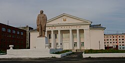
- Noril'sk (Норильск) - It is a city in Russia located in the Krasnoyarsk Territory, in Northern Siberia; it rises at a latitude of over 69 ° north and is the second city in the world by population beyond the Arctic Circle (after Murmansk) and the northernmost in Siberia. On the other hand, it is second to Yakutsk in terms of cities located on an area with permanently frozen ground (permafrost). The mosque of the city, built in 1998 and belonging to the local Tatars (or Tartars) community, is considered the northernmost Muslim place of worship in the world and also the city theater, the Polar Drama Theater, built in 1954 is the northernmost of the Land. Thanks to the presence, in the Norillag gulag, of important architects taken prisoner by the communist regime, Norilsk has a historical center in the classic socialist style, characteristic of the Stalin regime.
Other destinations
- Bolshevik Island (Большевик остров) - It is the southernmost island of the archipelago of Severnaya Zemlya, in the Russian section of the Arctic Ocean, between the Laptev Sea and the Kara Sea, constituting the second largest island in the group, after the island of the October Revolution, which is located a little further north, separated by the Strait of Šokalsky. The Bolshevik island is covered by at least three glacier systems: the Leningrad glacier, the Semënov-Tjan’-Šan'skij glacier, and also the small Kropotkin glacier. The whole island is protected byUNESCO.
- Putoransky Nature Reserve (Путоранский заповедник) - This Arctic land, full of rivers perennially (or almost) frozen on the surface and an incredible wealth of fauna (including wolves and polar bears) is a truly unique place in the world.
How to get
Almost the entire region is protected with regard to the entry of foreigners by special and strict laws. However, if you are stubborn and want to visit these inhospitable and arctic lands, you can request (preparing to wait a long time for an answer) a special explorer authorization, in addition to the normal documents required for a trip to Russia. Noril'sk and Dudinka have two small airports or it would be better to say simple runways equipped for landing and take-off.
How to get around
What see
What to do
At the table
Safety
Other projects
 Wikipedia contains an entry concerning Tajmyr district
 Commons contains images or other files on Tajmyr district