
The Danakil Depression is a desert area in the Afar region of northeasternEthiopia, north of the Great Rift Valley that is widely known locally as the Dallol depression.
This is both the hottest region on earth averaged year round and one of the most geologically active.
Understand
| Danakil Depression | ||||||||||||||||||||||||||||||||||||||||||||||||||||||||||||
|---|---|---|---|---|---|---|---|---|---|---|---|---|---|---|---|---|---|---|---|---|---|---|---|---|---|---|---|---|---|---|---|---|---|---|---|---|---|---|---|---|---|---|---|---|---|---|---|---|---|---|---|---|---|---|---|---|---|---|---|---|
| Climate chart (explanation ) | ||||||||||||||||||||||||||||||||||||||||||||||||||||||||||||
| ||||||||||||||||||||||||||||||||||||||||||||||||||||||||||||
| ||||||||||||||||||||||||||||||||||||||||||||||||||||||||||||
This is the land of "Ardi" (Ardipithecus ramidus) and "Lucy" (Australopithecus afarensis) - hominids which have been proposed as among our first putative ancestors. In June 2010, the oldest direct evidence of stone tool manufacture was found in this region and attributed to Australopithecus afarensis hominids dating back more than three million years ago.
Near the southern end of the Red Sea an immense, more or less triangular, depression descends far below sea level - some points near the ghost town of Dallol are nearly 120 m below sea level). Known as the Danakil/Dallol Depression, the northern part is extremely hot and dry and an extension of the Great Rift Valley. In this seemingly inhospitable area live the nomadic Afar people who number about 3 million and largely disregard the notional borders between Ethiopia, Eritrea, Djibouti and Somaliland.
The whole Afar Depression is a plate tectonic triple junction where the spreading submarine ridges that formed the Red Sea and the Gulf of Aden emerge on land and meet the East African Rift. The Afar Depression is one of two places on Earth where a mid-ocean ridge can be studied on land, the other being Iceland. The Afar is slowly being pulled apart at a rate of 1-2 cm per year. The floor of the Afar Depression is composed mostly of basaltic lava. The Afar Depression and Triple Junction also mark the location of a mantle plume, a great uprising of the earth's mantle that melts to yield basalt.
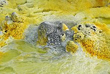
This place, which used to be part of the Red Sea, has kilometres of salt deposits. In some places the salt deposits are about 5km (3 mi) thick. Below many salt lakes are substantial sources of volcanic heat which causes hot water to rise through layers of salt and deposit anhydrites. Minerals also get dissolved and are deposited near the springs, and form shapes very much reminiscent (but smaller than) hornitos on basaltic lava flows. Sulphur, other minerals and possibly Thermopylae bacteria cause spectacular colours.


This is a vast expanse of blisteringly hot desert with lava flows and salt plains and lakes that lie below sea level. Active and extinct volcanoes lie along a south–north axis with the extremely salty Lake Afrera, at 120 m below sea level, kept alive by the many thermal springs feeding it.
Dallol offers an opportunity to see the first signs of a new ocean basin forming. The Dallol volcano, the only volcanic crater below sea level on land, has remained dormant since 1926, as the seabed it will one day occupy gradually widens. South of Dallol, rectangular salt slabs are cut and transported up into the highlands in a near endless procession of camel caravans. The salt canyons south of Dallol Mountain are some of the most impressive geological features in the area. It looks like another planet because there are lots of colourful rocks in each metre of terrain. It looks like something out of a science fiction novel.
Dallol is at the northern-most extension of the Great Rift valley - the largest geographical feature in Africa (if you discount the erg and reg of the Sahara) and the only such feature easily discernible from the Moon by the first Americans to walk there. Because it's below sea level it seems to trap all the heat. The most recent of its craters, Dallol, was formed during an eruption in 1926. Colourful hot brine springs and fumarole deposits are found in the Dallol area with some areas that are more than 116 m (328 ft) below sea level. There are hot yellow sulphur fields among the sparkling white salt beds. Heat isn’t the only thing people feel in the Dallol Depression. Alarming earth tremors are frequently felt. There are also several active volcanoes.
Erta Ale, an active shield volcano, is another impressive natural phenomenon. It is the most active volcano in Ethiopia. Erta Ale is 613m tall, with a lava lake, one of only five in the world, at the summit. It is the longest existing lava lake, present since 1906. Erta Ale, in whose crater lies the world’s only below sea level land volcano, has techni-colored landscapes, incredible mineral deposits. Sulphur lakes and bubbling sulphur springs are fascinating sights not to be missed.
The ghost town of Dallol, built from salt blocks and which almost straddles the Eritrean border to the east of the Tigrayan highlands, is officially listed as the hottest place on Earth, with an average annual temperature of 35 °C (95 °F) and hottest daily temperatures topping 40 °C year round. Much of this vast and practically unpopulated region lies below the driest and most tectonically active areas on the planet. The Danakil is an area of singular geological fascination. A strange lunar landscape studded with active volcanoes malodorous sulphur-caked hot springs. Solidified black lava flows. And vast salt encrusted basins. It is some measure of the Danakil’s geological activity that more than 30 active or dormant volcanoes roughly one quarter of the total as listed by the Smithsonian instituted global volcanism program. These volcanoes are all geological infants having formed over the past million years and with a great many taking their present shape within the last 10,000 years
Get in

The two main access points to the Danakil are
- Berahile – about 120 km and 2 hr from Mekele along the traditional salt caravan route to Lake Asale. Some folk have estimated that a million camels a year passed this way in 2007! This is still at an altitude of about 1000 m and so the heat is not yet oppressive - even though it's down in a valley between some very dry looking peaks. Carefully built Tigraian houses and clean streets are intermixed with the more rudimentary Afar huts. This is the last place for a cold(ish) drink for quite a while; you can even grab a beer at the bars that cater mostly for the military on the dusty descent into town.
- Serdo – a god-forsaken town on the newly asphalted Assab Road about 3h drive from Lake Afrera. This more southerly route used to be a lot less popular but the smoother asphalt has drastically changed that.
You might even consider a loop starting in Mekele and travelling via Berahile, Hamed Ela, Dallol, Lake Asale, Erta Ale, Lake Afrera and returning via Serdo. Done in this direction would obviate the need to do battle with the Afar Tourist Commission in Semera about 50km before Serdo if you're travelling from Addis Ababa. Allow about USD80 a day for three or four (depending on your haggling skills and how rich you look) armed Afaris to accompany you either way. Theoretically these guys should provision themselves but it's probably wise to discuss this aspect of things as part of the original negotiation. If they've got relatives along the way this can work out cheaper because they can call on clan loyalty and hospitality – equally it may become more expensive if some need to cadge a ride for clinic treatment, etc.
Get around
See
- 1 Dallol. Hot brine springs with multicoloured deposits of salts, sulphur and iron compunds.


- 2 Erta Ale (or Ertale or Irta'ale). The crater of this volcano contains a lake of liquid lava. Hike up at night when it is not so hot with your guides and armed guards, view the lava lake in the dark, then catch a few hours sleep at the summit before walking back down before the day's heat rises too far.
- 3 Lake Afrera (Afdera).
- 4 Lake Asale (Lake Karum). The salt flats are mined by hand, with the slabs of salt loaded onto to camel trains and taken to Hamed Ela, from where they are trucked to Mekele.
Do
Eat
Drink
Sleep
Stay safe
As of January 2020, the government of Canada advises against all travel to Danakil, the government of New Zealand recommends avoiding non-essential travel to Danakil and the Australian government suggests reconsidering your need to travel to Danakil. The Irish government gives the following specific remarks:
"Historically there have been incidences of attacks and kidnapping of foreigners near the Danakil Depression in Afar region. Travel to this area should only be undertaken with a recognised and reputable tour operator supported by a military or armed escort."
In 2012 a group of tourists was attacked, with five European tourists killed and two others kidnapped, and in 2017, a German tourist was shot dead and an Ethiopian guide shot and injured while at Erta Ale, so if you do choose to go, check on current conditions and take careful, strong precautions. It is particularly important not to stray too far from the rest of your tour group.
There are also safety concerns unrelated to any threat of violence. There are no warning signs or fences, but you should stay at least a metre from the Erta Ale crater's edge. Don't touch the water in Dallol ponds, as it is acidic. And if you should get injured, the next hospital is in Mekelle, which is several hours away through Berhale.
The people of this region have always had a bad reputation for being hostile rather than welcoming to outsiders. Their fearsome curved knife, the jile, was used to castrate infrequent visitors as late as the 1930s.