| Erta Ale | |
 | |
Location  | |
| State | Ethiopia |
|---|---|
| Region | Afar region |
| Height | 613 m a.s.l. |
Erta Ale it is the most active volcano in Ethiopia and is located in Danakil at the center of the chain of the same name.
To know
Geographical notes
The entire chain of volcanoes ends in the north in the salt plain, in the south it extends to Giulietti lake (also called Lake Afrera), to the west it is bounded by the Ethiopian plateau escarpment and to the east by the Danakil escarpment. It occupies an area of 2,350 km². Coral sediments emerge on the lateral escarpments, between the altitudes of -30 and 90 m a.s.l. These sediments, together with the imported saline sediments, show that this depression was once occupied by the Red Sea, believed to be between 200,000 and 80,000 years ago. The region, entirely desert, is formed by basaltic crust, the result of the enlargement of the earth's crust in this area. The chain has many shield volcanoes: the main ones, proceeding from north to south, are the 287 meters high Gada Ale (or Kebrit Ale), the 613 meters high Alu-Dala Filla (or Dalafilla), the 668 meters high Borale Ale. , the Erta Ale, the 521 meter high Hayli Gubbi and the 1031 meter high Ale Bagu; the latter is the only one not located on the main axis of the fault.
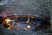
Erta Ale has a permanent lava lake. The heat induced by the mantle sometimes fails to keep the crust in a liquid state, so every now and then a black crust is formed on the lake resulting from cooling. Usually, however, the temperature of 1,200 ° C allows the maintenance of the liquid state in the lake, on whose surface it is possible to observe floating basaltic pieces as if they were icebergs. It is one of the few volcanoes in the world that allow the observation of this extraordinary and spectacular phenomenon. The fault that crosses the depression, which marks the removal of the Arab plate from the African plates (the Somali and the Nubian ones), allows the release of magma, a phenomenon that normally occurs only in the oceanic ridges, in the open sea and at great depth, therefore very more difficult to observe.
Background
In 1968, a first Franco-Italian expedition of volcanologists arrived on the summit of Erta Ale. Haroun Tazieff and Giorgio Marinelli observed two lava lakes: a very active lake of one hundred meters in diameter in the north crater and a less active lake of 65 meters in diameter in the central crater. The two were located 165 meters below the crater rim, probably active since 1906. The level of the lakes varies greatly over time: in 1971 they were only about ten meters from the crater rim and had the same size in observations of the year following; later there were lava spills that invaded the edges of the caldera. This situation lasted until 1974. The war in the region did not allow any further observations on the spot until 1992, except for a few rare flyovers or observations from space. The level of the lake had meanwhile dropped to one hundred meters with a diameter of 40 to 70 meters. In 2001, with the end of the conflict with Eritrea, new scientific expeditions were able to go there. The lake then measured 80 meters by 100 meters, and was situated at a depth of 80 meters with regular emissions of lava fountains 5-10 meters high. Since this date the volcano is regularly visited, the site shows sudden and important changes both in its extension and in its depth. After a short period of calm, the eruption started again. The lava lake of the southern crater has reappeared, with variations in its level varying from month to month. On November 5, 2008, a new volcanic activity began with the release of lava flows from a fracture that is supposed to have opened east of the Erta Ale volcano.