| Danakil | |
 | |
| State | Ethiopia |
|---|---|
| Region | Afar region |
Danakil it is a desert area Ethiopian part of the Afar region.
To know
There depression of the Danakil or of Afar (locally also by Dallol) in the extended sense is a region of the Horn of Africa which includes the state of Djibouti and part ofEritrea andEthiopia. However, this article refers to the Ethiopian Danakil.
L'Afar, the region that contains the Ethiopian Danakil, is known to be one of the most prolific areas of fossil finds of hominids: Lucy, an almost complete skeleton of Australopithecus afarensis more than three million years ago, found in this area, Ardi, a skeleton of Ardipithecus ramidus more than four million years ago, as well as the fossil remains of Homo sapiens idaltu.
This region is both the hottest on earth (as an annual average temperature) and the most geologically active.
Geographical notes


In the depression of the Gibutian Danakil there is the lowest point of theAfrica, the Assal lake, which is located at an altitude of -155 m above sea level, while in the Ethiopian Danakil it reaches up to about -120 m. The Auasc River is the only river that flows into the Danakil depression, a region where it ends in a sequence of salt lakes. This place, which was part of the Red Sea, has about 1,200 km² of the depression are covered with salt, and the salt industries are an important economic source for many Afar tribes. In some places the salt deposits are about 5 km thick. Under many salt lakes there are substantial sources of volcanic heat that cause hot water to rise through salt layers and deposit anhydrites.
The depression of Afar was formed at a triple junction, called the triple Afar junction, that is the meeting point of three tectonic plates in continuous expansion, which formed the Red Sea and the Gulf of Aden, and which in the Afar triangle emerge in surface. The only other place where an ocean ridge can be studied on the surface is at Iceland. The Afar plain is slowly widening at a rate of 1–2 cm per year.
The Dallol offers the opportunity to see the first signs of a new ocean basin forming. The soil is mainly composed of basaltic lava. One of the most active volcanoes in the world is located in this area: theErta Ale which is the only volcanic crater below sea level on the mainland, which remained inactive until 1926. Below the surface there is a so-called gush of the earth's mantle, a large reservoir of lava that rising to the surface gives rise to the formation of basalt rocks.
South of Dallol, rectangular slabs of salt are cut and transported to the highlands in an almost endless procession of camel caravans. The salt canyons south of Mount Dallol are some of the most impressive geological features in the area. It looks like another planet because there are many colored rocks in every meter of land.
Heat isn't the only thing people feel in Dallol's depression. Alarming earth tremors are frequently experienced. There are also several active volcanoes.
When to go
| Climate | gen | Feb | mar | apr | mag | down | Jul | needle | set | Oct | nov | dec |
|---|---|---|---|---|---|---|---|---|---|---|---|---|
| Maximum (° C) | 36 | 36 | 39 | 41 | 44 | 47 | 46 | 45 | 43 | 42 | 39 | 37 |
| Minimum (° C) | 25 | 25 | 26 | 27 | 28 | 30 | 32 | 31 | 32 | 30 | 27 | 26 |
The climate varies from 25 ° C during the rainy season (September-March) to 48 ° C during the dry season (March-September).
The lowlands ofAfar they are dominated by heat and drought. There is no rain for most of the year; on average, 100 to 200 mm of rain fall annually, with an even lower average for coastal areas.
Territories and tourist destinations
How to get
By car

The two main points of access to the Danakil are:
- Berhale - About 120 km and 2 hours from Macallè along the traditional salt caravan route to Karum lake. Some estimate that around one million camels passed through here in 2007! The route is about 1,000m and the heat is not yet overwhelming, although it is at the foot of a valley between some very arid looking peaks. Houses of the Tigrè region carefully built and clean streets mix with the huts Afar more rudimentary. This is the ultimate place for a refreshing drink; you can also grab a beer in the typically military bars along the dusty descent into the city.
- Serdo - A godforsaken city on the asphalt road to Assab about 3 hours drive from Giulietti lake (or Lake Afrera). This more southerly route was far less popular, but the smoother asphalt changed things dramatically.
You could also consider a ride starting from Macallè and goes through Berhale, Hamed Ela, Dallol, Karum lake, Erta Ale, Giulietti lake and back away Serdo. Done in this direction would have obviated the need to fight with theAfar Tourism Commission to Semera about 50 km before Serdo traveling from Addis Ababa. Consider around $ 80 a day for three or four armed afari (depending on bargaining skills and budget) that will escort the journey in either direction. Theoretically these guys should provide their own room / board, but it is probably wise to discuss this as an integral part of the original negotiation. If they have relatives along the way it can be useful for finding safer and cheaper accommodation.
How to get around
By car
The main means of transport in Danakil is the car, and where there are no normal roads, pack animals (mostly camels, to a lesser extent, donkeys) are used.
On the train
Railways are not clean, just like any pedestrian or cycling infrastructure.
By bus
Public transport is almost non-existent, even where there are paved roads.
What see


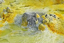
- Dallol - Hot salt water springs with multicolored deposits of salts, sulfur and iron compounds.
- 1 Giulietti lake (or Lake Afrera) - Salted volcanic lake of 100 km² at -102 m below sea level discovered in 1928 by explorers Italians. Like Lake Karum, it is a place of industrial production of salt, although here it is obtained in a different way, namely by evaporation from salt water.
- 2 Karum lake (Lake Assale) - Not to be confused with the Assal lake in Djibouti. Located at an altitude of 116 meters below sea level in an area of approximately 50 km², it is one of the three largest salt lakes in Danakil and a commercial salt extraction site. Near the shore the lake is covered with a thick crust of salt, along which you can easily drive by car, as on the winter ice of the Baikal lake. Do not miss the salt extraction sites where workers carve slabs of about ½ m² from the crust of salt. This virtually unchanged process for centuries continues uninterruptedly from sunrise to sunset. The salt pans are worked by hand, with the salt slabs loaded every evening onto the camel caravans and brought to Hamed Ela, to be transported to Macallè (also Mekele).
- 3 Bakili Lake - Another salt lake with an area of 40 km², located not far from the settlement of Karuma to the south-east. Typically it is not included in tourist excursions.
- 4 Dallol volcano - The highlight of the program is any trip to Danakil. This is an active volcano, which, incidentally, has a negligible height (less than 100m from the foot of the crater and still 48m below sea level), with a crater diameter reaching 1,450m. This crater is a landmark, like its surface, which represents a solid rock to form different formations of salt, sulfur and andesite, which are practically unmatched in the world and, thanks to the unusual color palette, looks more like the surface of another planet. Since this site is still active, hot sulfur springs, the surface of the Dallol crater is constantly changing, and lakes with a diameter of up to several meters are formed near the springs with a characteristic yellowish color of the water. Due to the sulfur emissions in the air there is the smell of rotten eggs. For its hot sulfur springs. In principle, this landscape was formed during the last Dallol eruption, which took place in 1926.
- 5 Abandoned settlement of Dallol - Located on the edge of the crater, the former workers' village, built around 1918 in the places of extraction of sylvinite by one of the companies Italian. From here, an industrial railway line was placed on the Red Sea through today's territory of theEritrea. After the Second World War, the railway was dismantled, the production of potassium ceased and the village fell into desolation. The houses of the salt blocks they built in Dallol are partially preserved. Tourists are not taken there (most likely for safety reasons), but several buildings, if you look closely, can be seen on the horizon from the side of the crater.
- 6 Salt Canyon - Located in the southwestern outskirts of Dallol, it was formed by erosion processes of up to 40 m high.
- 7 Pond Gaet'ale - Small but picturesque salt lake located 4 km south of Dallol with the second salinity rate of water in the world (43%!). It was formed after the 2005 earthquake. The water temperature is kept in the interior of 50-55 ° C. Due to this characteristic the water boils on the surface due to the gases, in particular with a geyser that gives the water its typical yellow color.
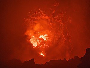
- 8 Erta Ale - The most famous active shield volcano (literally known as "smoking mountain") in Ethiopia. The crater of this volcano contains a lake of liquid lava. It is one of the five active volcanoes on the planet with a permanent lava lake and it is precisely for this lake that tourists go there, making Erta Ale one of the main attractions (along with Dallol). To look at the lava lake, it is necessary to reach the top of the volcano, which can only be done on foot via the rocky path that descends from the base camp. A night trek accompanied by your guide and your armed escort is ideal for observing it in the dark when the heat is not so oppressive. You can camp on the summit and then descend with the first light of dawn (travel time of at least 2.5 hours one way). Unfortunately, during the 2010 eruption, the lake level dropped significantly compared to the crater rim, and lost some of the old charm: in fact the lava flows can now only be seen from a distance, from a height of about 80 meters, and on windy days the crater smokes so much that it is not possible to observe it entirely. However, the shape of the crater and the level of the lava lake often change, and the next eruption, capable of once again radically changing the views on the top, could take place at any time.
What to do
Bathing in a salt lake is quite popular with both tourists and locals. The Giulietti lake Unlike Karum lake, it does not have the banks covered with a crust of salt. It is thought that the waters of Lake Giulietti have particular properties comparable to those of Dead Sea.
At the table

In the base camps of Dallol andErta Ale, the food for tourists is prepared in camp kitchens and in the settlements can eat at one of the roadside kiosks with the usual range of choices: enjera with sauce (adored by all Ethiopians), pasta or rice, fried goat meat, boiled vegetables, canned fish, etc.
However, those who venture into this region will almost certainly be part of an organized excursion, so most likely you won't have to worry about where to get food.
Drinks
Drinking water, beer, Coca-Cola and other beverages (all bottled) and of course, the famous Ethiopian coffee prepared in the traditional way.
Tourist infrastructure
In Danakil today it is not possible to find comfortable accommodation in which to spend the night. The nearest town where there are relatively decent hotels is Macallè. Those who venture into this depression have three options for spending the night:
- Don't sleep at all; and perhaps this is a good option for those who have only come for two days.
- Spend the night at Dallol base camp and / or on the top of the volcano Erta Ale.
- Take advantage of one of the pensions in small towns and villages.
Dallol base camp is an hour's drive from Berhale, close to Karum lake. There you sleep in the open on trestle beds, without basic services. On the top of Erta Ale there are no beds so the only option are mattresses and sleeping bags scattered on the bare earth. Compared to all this, the conditions in the pensions are quite good. There are dorms for groups with mattresses spread out on the floor, and there is the opportunity to use a bathroom.
Safety
In 2012 a group of tourists was attacked, with five European tourists killed and two others kidnapped, and in 2017 a German tourist was shot dead and an Ethiopian guide was injured while they were at theErta Ale. It is especially important not to stray too far from the rest of the group.
That said, there were several meetings between the prime minister in 2018 Eritrean and the president Ethiopian which culminated on September 16, 2018 in Jeddah with the historic signing of a peace treaty that seems to have put an end to any kind of hostility between the two countries, which finally accepted the border line established in 2000, freed prisoners of war and demolished military barricades along the border . L'Saudi Arabia, which has economic interests in this region, has helped the peace between the two countries.
Although there are no warning signs or fences, one should stay at least one meter from the rim of the crater of theErta Ale. Do not touch the water in the Dallol ponds, as it is acidic. In case of injuries of various kinds, the nearest hospital is that of Macallè, which is several hours away from Berhale.
Thanks to the dry climate, tropical infectious diseases in the region are relatively rare, but cannot be completely ruled out, so it is advisable to carry malaria medications with you when needed.
The people of this region have always had a bad reputation for being more hostile than welcoming to strangers. Their fearsome curved knife, the jile, was used to castrate rare visitors until the 1930s.