The Death Valley National Park (Valley of death) lies in the east California on the border to Nevada and is a much visited national park. It lies between the mountain ranges of the Inyo Mountains (3385 m) in the west and the Amargosa Range (2043 m) in the east on the border with Nevada and is divided by the Panamint Range (3368 m). The park extends for approximately 210 km from northwest to southeast. The Panamint (495 m) and Death Valley (-86 m) are up to 30 km wide.
| location | ||
| ||

places
There are three settlements in the park that are mainly used for tourism today.
- Furnace Creek Ranch
- Stovepipe Wells
- Panamint Springs
Because of the remoteness and the resulting long supply routes, the prices for services are higher there than in more densely populated areas.
Other goals
→ See also the itinerary In the north of the valley of death
background
getting there
- of Las Vegas from approximately 130 miles northwest via Nevada Hwy 95 (Veterans Memorial Highway) and Route 373 via Death Valley Junction to the east side of the park, from there approximately 20 miles to the Furnace Creek Visitor Center.
- alternatively from Las Vegas from approximately 90 miles northwest on Nevada Route 160 and 372 to Pahrump and California Route 178 via Shoshone to the southeast side of the park, from there about 60 miles to the Furnace Creek Visitor Center.
- from California Hwy 395 from Lone Pine approx. 50 miles southeast to the west side of the park, from there approx. 100 miles to the Furnace Creek Visitor Center.
mobility

Tourist Attractions


The national park is worth visiting everywhere because of its geographic peculiarities. Furnace Creek area (east side)
- 1 Badwater, the deepest point in North America, is about 86 meters below sea level
- 2 Devils Golf Course, an area littered with lumps of salt
- 3 Artist’s Drive, a street along colorful sediments
- 4 Zabriskie Point, a favorite with photographers, is 2 minutes from the car park
- 5 Dante's View, overview of almost all of Death Valley
- 6 Furnace Creek, oasis with a visitor center, supply and accommodation options for campers
- Harmony Borax Works
- Twenty Mule Team Canyon
- Golden Canyon
- Natural Bridge


Scotty's Castle area (north)

- 7 Scotty's Castle
- 8 Titus Canyon
- 9 Ubehebe crater
- 10 The Racetrack, place of the mysterious, wandering stones
- Eureka Dunes, the largest dunes


Stovepipe Wells area (northeast)
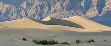


- 11 Mesquite Flat Sand Dunes, perhaps the more beautiful dunes
- Mosaic Canyon
- Salt Creek

Panamint Springs area (west side)
- 12 Darwin Falls, 15 m high waterfall
- 13 Father Crowley Vista, viewpoint over the Panamint Valley
- Lee Flat Joshua Trees
- Wild Rose Charcoal Kilns
- 14 Aguereberry Point, alternative viewpoint over Death Valley

activities
- hikes
- horse riding
- camping
kitchen
nightlife
security
Death Valley is not entirely harmless.
Contact via mobile phone cannot always be established. In the event of a breakdown at nightfall, it is not always likely that other people will cross your path. Even if Death Valley is the hottest place. There are also heavy rains (approx. 1-5 times a year), up to floods of mud, which in the worst case carry vehicles away or simply prevent them from continuing their journey.
In any case, you should take enough liquid with you, possibly for 2 days, and something to eat.
climate
trips
literature
Web links
- official page of the national park