| Figuig (ⵉⴼⵉⵢⵢⵉⵢ, فكيك, فجيج) | |
 | |
| Information | |
| Country | |
|---|---|
| Area | 200 km² |
| Population | 10 872 hab. () |
| Density | 54,36 inhab./km² |
| Postal code | 61000 |
| Location | |
 32 ° 7 ′ 0 ″ N 1 ° 13 ′ 37 ″ W | |
| Official site | |
Figuig is a small town and an oasis wedged far east of MoroccoPleasant but very out of the way oasis, it is the ideal place to cut yourself off from the world while marveling your eyes.
Understand
Figuig is a town surrounded by small mountains where about 12,000 inhabitants in the extreme east of Morocco in a desert area. A true oasis lost on the border with Algeria, it was once a popular destination for many travelers. Since the border has been closed, only a few adventurers take the trouble to make the detour to come and see Figuig. Yet the small town does not lack charm, between its oasis of 200,000 palm / date trees and the seven ksour (“Fortresses”) that surround it, it has an unknown wealth. Morocco is also trying to have this heritage recognized by UNESCO. Such recognition could open up the small town.
Weather
Located on the edge of the Sahara, the climate that reigns in Figuig is desert type. The temperatures in summer are very hot (up to 45 °) with night and morning lows of between 20 and 25 °. The city is also located near the Atlas Mountains, which translates into relatively cool temperatures. to cold in winter between 5 and 20-25 °. It can sometimes snow in winter (but this is still unusual) |
To go

Because of its position and the closure of the border with Algeria (which is only 2 km from the city), the city is not very easy to access.
By car
- From Oujda, route 17 leads directly to Figuig. The road is relatively monotonous and deserted. The distance is also significant: 384 km.
- From Er-Rachidia take route 10 to Bouarfa then route 17. Likewise, the distance is important: 404 km.
By bus
There are daily buses connecting Oujda (in 7 h ) or Bouarfa (in 2 h ).
Circulate
To see

- Rock engravings
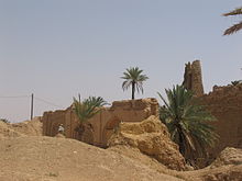

- 1 Ksar Zenaga
- Ksar El-oudahir
Do
To buy
Eat
- Café des Palmerais Boulevard Assan II – Some simple dishes like omelets or skewers and fries.
Have a drink / Go out
- Cafe Oasis Boulevard Assan II – In the public garden, pleasant for a coffee or other refreshment.
Housing
- Nanna guest house Rue Ouled Sellam Ksar Zenaga Figuig,
 212 536 897 570, 212 658 579 573, fax : 212 536 897 570
  for 1 person 400 DH HT full board, 335 DH HT half board and 260 DH HT per night with breakfast, wholesale price for couples and for groups of more than 9 people. – Double room, with two "twin" or triple bed. Guide to visit the area included. Internet connection, telephone and fax, laundry service on request.
 - 1 Hotel Figuig RN 17 61000 Figuig – Hotel in the palm grove. Possibility of pitching a tent in the hotel garden. Possibility of catering but limited.
- Oasis Hostel Jamaa Ksar Zenaga Street - Figuig, 212 36 89 92 20, 212 68 26 38 20, e-mail : [email protected] per day, 1 person: 100 DH / 300 DH with all meals, 2 persons: 170 DH / 600 DH with all meals. – Inn in a traditional house in the heart of the Zenaga ksour. Traditional meal also in a friendly atmosphere.
- Dar Amane Rue Sidi Sallah, Figuig
Communicate
Around
- 1 Rock engravings from the region of Figuig – On the track between Figuig and Ich there is the greatest concentration of rock painting in Morocco; a real open-air museum. This discovery is preferably done in an all-terrain vehicle because the track is quite stony. The village of Ich is also a place to see, a typical Ksarien village out of time nestled in the depths of Morocco, on the border with Algeria.
| This article uses content from Wikipedia's Figuig article. See the history of this page for the list of authors. |