Gökçeada is the largest island in Turkey, in the Aegean Sea northwest of the entrance to the Dardanelles Strait.
Understand
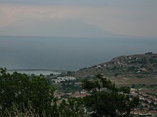
Gökçeada, in Çanakkale Province, is Turkey's largest island. Much of its 279 km² area is hilly. Cape Avlaka, near Uğurlu, is the westernmost point of Turkey.
In ancient times it was believed that Poseidon, the Greek god of the sea, rested his horses in the deep sea between Gökçeada and the Greek island of Samothrace, to the north of Gökçeada.
The former name of the island, İmroz (from its Greek name Imvros) was changed to Gökçeada (by which the island is best known in Turkish nowadays) in the 1970s, as Turkish-Greek relations deteriorated due to the Cyprus dispute. In ancient times, the island was also known as Imbros.
Nearly 10,000 people live on the island; there are some military personnel and tourists mainly visit in the summer. Due to bad relations between Greece and Turkey in the 20th century ethnic Greeks (or Greek speakers) were encouraged to emigrate and ethnic Turks to immigrate. Nowadays the island has a small Greek community of about 250 mostly old people, scattered in a number of villages. However in summer the number of Greeks on the island rises as many families, originally from Gökçeada but now living in Greece, return to their houses for holidays or to visit their grandparents.
Climate
| Gokceada | ||||||||||||||||||||||||||||||||||||||||||||||||||||||||||||
|---|---|---|---|---|---|---|---|---|---|---|---|---|---|---|---|---|---|---|---|---|---|---|---|---|---|---|---|---|---|---|---|---|---|---|---|---|---|---|---|---|---|---|---|---|---|---|---|---|---|---|---|---|---|---|---|---|---|---|---|---|
| Climate chart (explanation ) | ||||||||||||||||||||||||||||||||||||||||||||||||||||||||||||
| ||||||||||||||||||||||||||||||||||||||||||||||||||||||||||||
| ||||||||||||||||||||||||||||||||||||||||||||||||||||||||||||
Gökçeada's climate is Mediterranean, however it does have slightly lower temperatures than an average Mediterranean climate. As it is an island with very windy weather, its daily temperature variation is very low, especially on the coasts.
As the island is only accessible by ferry, it is very important to mention that wind can cancel ferries year-round. This is especially true during winter, when south-southwesterly windstorms, called Lodos storms, are common.
Summers, while rarely very hot thanks to the Mediterranean's moderating effects, are still quite warm, and not all that comfortable, as the waters nearby keep nights very warm and very humid. Rain in summer is rare, and cloudy spells don't last for long, when they do happen.
Spring and fall are both mild to warm, and generally quite nice, especially on the warmer halves of the seasons. Rain is occasional during this time of year, with around 7 days of rain a month.
Winters are cool with both chilly and mild periods. It's usually quite rainy, with around 12-14 days of rain a month. Snow on the island is uncommon but it can happen once or twice a year.
Get in
Gökçeada has no air service and can only be reached by ferry, usually from Kabatepe.
Gestaş Ferry takes 90 min from Kabatepe to Gökçeada, sailing M-F 3 or 4 times and Sa Su twice. The single fare in 2020 was adult 6 TL, car 64 TL plus 1.5 TL per passenger; all fares are cash only.
In summer Gestaş usually also operates a waterbus for foot passengers from Çanakkale, a one hour crossing. This only sailed intermittently in 2020 and the schedule and fares for 2021 have not been posted. It's more likely to be blown out by bad weather than the car ferry.
The island's ferry port is 1 Kuzu Limanı, 4 km east of the main town Merkez. Dolmuşes for Merkez, Yenibademli and Kaleköy meet the ferries.
The mainland port Kabatepe is a tiny place on the west coast of the tip of Gallipoli. There may be a direct bus from Istanbul, connecting with the ferries. But normally you have to take a bus heading for Çanakkale, which arrives in Eceabat on the east coast in order to cross the Dardanelles. Get off at Eceabat and take a dolmuş the last 12 km across the peninsula to Kabatepe. If there isn't one running, that suggests no ferry is due any time soon, in which case you'll find Kabatepe very peaceful indeed.
By road follow D550/E87/E90 south past Gallipoli, and look for signs for “Kabatepe-Gökçeada Feribot” as you approach Eceabat. The side-road to the port is a well-made modern highway.
Get around

Public transport is severely limited on the island, even in summertime. There are minibuses several times a day between the central town (Turkish: Merkez, officially known as Gökçeada town, the only settlement of the island with a significant population) and the harbour (Kuzulimanı, 4 km east of Merkez). There are also minibuses once every two hours between central town and Kaleköy via Yenibademli. The minibus service between central town and Uğurlu (via Dereköy, also passes through the junctions of the roads leading to Zeytinli and Tepeköy) is once a day, and there is the minibus service between central town and Aydıncık (also known as Kefalos) beach.
Drivers, most of who themselves are visitors, are generally friendly towards hitchhikers. They tend to stop even without a sign when passing by some unlucky visitor who doesn’t have the privilege of having a car or bike and thus walking under the baking sun in some weird location. However, this may not be true for wintertime when already empty island roads are more deserted.
Taxis are limited in number and at least twice or three times more expensive than other places in Turkey (for example, Istanbul).
Be sure to obtain (or take a look at) a good map of the island before going there. By doing so, you will let directions and locations fit much more easily into your mind. There are plenty of island maps available on the web.
See


Atmospheric Greek villages of the island, namely
- 1 Bademli. (Gliki in Greek, also known as Eskibademli, i.e. Old Bademli) – about 3 km north of Merkez and 1 km south of Kaleköy on the top of a hill. The balcony of the deserted village school offers a magnificent view of mountains and the plain of the island, the Aegean Sea, and the Greek island of Samothrace.


- 2 Kaleköy. (Kastron in Greek) – 4 km north of Merkez. There are 2 parts of this village, which are 10 minutes away from each other by walk: the newer neighborhood and the lovely old village on a hill sloping away from the sea (Yukarı Kaleköy). There is a citadel (or what is left of a citadel) overlooking the sea above the old village. There is no admission fee, gate, guard or information but there is the usual large flagpole. The cove below the village is small and rocky but prettier than some other parts of the coast.
- 3 Zeytinli. (Agia Theodori in Greek) – 3 km NW of Merkez. Situated on a gentle slope surrounded by olive groves.
- 4 Tepeköy. (Agridia in Greek) – about 10 km NW of Merkez. Situated on a hill overlooking the turquoise dam lake and surrounding hills around.
- 5 Dereköy. (Skinoudi in Greek) – about 15 km west of Merkez. Situated on two slopes of a valley divided by the Merkez-Uğurlu road this village is said to have once been Turkey’s biggest, with a population of 10,000, but is now almost totally deserted. Many parts of the village are more or less abandoned, with a heavy ghost town feel, and some parts are outright ruined. Be sure to visit the dark abandoned laundry building.
All these villages (except Kaleköy’s newer part) were built on hills or considerably away from the sea to avoid the pirate raids of the past.
If you do not have a car or a taxi waiting for you, do not forget to take at least three liters of bottled water (that means two large bottles) with you when visiting the villages since you may have to walk back to where you are staying and there is no guarantee that you will find a source of drinkable water (or somewhere selling it) in these mostly deserted villages or on the way.
- 1 Kefalos Beach (Aydıncık). and the salt lake – in the southeast part of the island, about 10 km from Merkez. A low dune separates the sea and the lake, which is very shallow, about 1 m deep at most. In the olden times, before commercial packaged salt was available, islanders produced their own salt here. The lake smells funny because of some natural chemical it contains, which is said to cure some skin problems. It is a good idea to first have a mudbath in the lake and then rinse in the sea (Be careful, there are lots of sea urchins –which can spoil your trip if they prick your skin, especially feet- around this area).
Yıldızkoy beach – Can be reached by following the trail starting behind Yenibademli (10 minutes). All around the cove is covered by mountains of black volcanic rocks.
Do
- Swim. You can swim virtually anywhere on the over 100 km coast of the island. The sea is totally free of any kind of pollution. Part of the northeastern coastal waters near Kaleköy have been declared Turkey’s first — and so far only — underwater national park. Therefore zipguns and other fishing is forbidden there. While the climate of the island is usually windy (and, thus, the sea is wavy), being surrounded by sea at all sides means you can usually find at least one beach with calm(ish) waters. The most popular beaches are Yıldızkoy in the north, Kefalos/Aydıncık in the south, and Gizliliman close to the village of Uğurlu in the west of the island. There is a shower at Gizliliman.
- Surf. Kefalos/Aydıncık beach has become quite popular with Turkish and international surfers, especially those from Bulgaria and other Balkan countries.
Buy
Honey.
There is only one ATM on the island, which is at Türkiye İş Bankası‘ in Merkez. Always have extra cash with you while on the island in case of ATM problems, and because ferries can be cancelled due to bad weather at any time (although rarely in summer).
Eat
There are quite cheap restaurants in Merkez and Kaleköy. Some of them offer breakfast too. Or alternatively, you can pick some mulberries and figs from one of island’s many unowned trees, buy bread and some feta cheese from the village stall, and ask the landlord/landlady of your guesthouse for some fresh tomatoes, green peppers, and grapes from the garden (they’ll be happy to give you away some for free) and here you have a Mediterranean breakfast!
Despite being an island, fish is neither abundant nor very cheap. The islanders seem to have a preference for mutton.
Drink
- Barba Yorgo in Tepeköy is a famous Greek tavern.
- Don’t miss drinking a cup of special Turkish coffee at Madam’s (Madam’ın Yeri) in Zeytinli. The lady who used to prepare and serve the coffee passed away some years ago, but her son keeps up the tradition.
Sleep
You can stay either in one of the few hotels located in some of the villages (especially in Kaleköy), or rent one of the many guesthouses (pansiyon) in Yenibademli (3 km to Merkez, situated in the lowland between Bademli and Kaleköy). Yenibademli’s guesthouses are terrible architecture (identical concrete boxes in rows in a number of parallel streets), but you can find a room (or rent a whole house) at any time of the year without prior booking. Another advantage of Yenibademli is that it is just a few steps away (yes, literally, there is a sign on the road which proclaims you are out of Yenibademli and at the same time you have entered Kaleköy) from Kalelöy. Yenibademli is also only 3 km away from Merkez via a relatively flat road which you can easily walk if you cannot find any public transport. The guesthouses in Yenibademli are cheap after bargaining, and payments are generally made daily and only in cash.
- Anemos Hotel, 98 Yukarı Kaleköy (at the upper side of Kaleköy), ☏ 90-554-541-47-37. Boutique hotel with a pool and restaurant. Each room is decorated with artworks and stones from the island.
- Zeus Bungalow Hotel, Kuzulimanı (very close to the harbour where ferries from the mainland anchor), ☏ 90 539 965 94 98. €21/29 with breakfast/with breakfast and dinner per person.
It is possible to camp almost anywhere on the island. Common sense means camping well away from any house or public spaces in the villages, from olive- and vineyards which look well-tended around the villages, and more than considerably away from military property (See Respect section). If you want to be on the completely safe side, there is also a campground at Aydıncık beach, which also has a little stall which offers basic necessities such as snacks and soft drinks. Secure your tent well against changeable winds. Large plastic containers of water can be bought cheaply and refilled with tap water at 'çeşme'. You may prefer to drink the bottled water and brew tea with the tap water as it is quite hard. Some areas may look ugly due to litter.
Stay safe
If you are camping don`t be alarmed by goats checking out your tent in the night. Just be reassured that you are less likely to be hurt by the forthcoming major earthquake than those staying in guesthouses.
Respect
Some parts of the island are military property and are marked with red boards with a picture of a soldier. To avoid trouble, do not enter or photograph these areas or those enclosed by obvious barbed wire.
Connect
Tourism information office – in Kaleköy, tel 90 286 887 28 00
As of Dec 2020, you can make a mobile phone call and might even manage 4G in Merkez town with Türk Telekom or Turkcell, but there's no signal from Vodafone. The rest of the island has no signal, and likewise the ferry, so finish any important calls before you leave Kabatepe on the mainland. 5G has not yet reached this area.
Go next
- Gallipoli peninsula
- Çanakkale
- Lemnos
- Samothraki