The Grande Randonnée 20 (short: GR 20) is a Corsican Long distance hiking trail from Calenzana (at Calvi) to the north Conc (at Porto Vecchio) in the south. The route is 170 km long.
The GR 20 is divided into the north part from Calenzana to Vizzanova and the south part from Vizzanaova to Conca.
Practical advice

Wild camping is not allowed on any part of the route. Therefore, a campsite (refuge) must be reached at the end of each stage. These are sometimes more than 6 hours apart, even if it is only a few kilometers as the crow flies.
You can fill up water bottles in every refuge. However, the refuges close at the beginning of October, so that you can no longer spend the night in the hut and you can no longer replenish supplies. In addition, the groceries in the refuges are very expensive.
The refuges have toilets, but you have to bring your own toilet paper.
Most of the path is very well marked with red and white stripes. Usually you can already see the next two of one marker.
Although it is sometimes possible to make yourself understood in English, at least a rudimentary knowledge of French is an advantage.
In October there are temperatures close to freezing at night at the refuges and often wind. Therefore, a sufficiently thick sleeping bag, a sleeping mat and enough warm clothing are necessary.
At some refuges there are animals that steal the food. This goes so far that light bags are bitten open or torn open. The food should really be stowed away or you should keep it close by.
preparation
The GR 20 should only be walked if you are sure-footed and fit. In addition, the weather should be checked before the climbing stages.
getting there
The capital Ajaccio has an airport connected to the train station by bus number 8. You can take the Corsican train from Ajaccio to Calvi. From there you can walk to Calenzana.
equipment
- Solid walking shoes
- Sufficient water for one stage and food for several stages if necessary
- Hiking backpack
- Hygiene:
- toothbrush and toothpaste
- Functional towel and curd soap
- Toilet paper
- Clock (is useful for arrival and departure - you can also set an alarm to start the tour in good time)
- Maps: The path is well marked, so maps are not necessary in principle. However, you can get lost in one or two places. It is reassuring to have maps available. The IGN TOP 25 4149 OT - 4253 OT are useful for this.
- Cloth bags / waterproof sacks for dirty laundry or hygiene products or food.
If you don't stay in a hut every time, you also need:
- tent
- Sleeping bag and sleeping mat
- Camping stove, lighter and camping utensils
Here we go
Stages
North part:
- Stage 1: Calenzana - Refuge d'Ortu di u Piobbu
- Stage 2: Refuge d'Ortu di u Piobbu - Carrozzu
- Stage 3: Carrozzu - Asco
- Stage 4: Asco - Tighiettu
- Stage 5: Tighiettu - Ciuttulu di i Mori
- Stage 6: Ciuttulu di i Mori - Castel de Vergio
- Stage 7: Castel de Vergio - Refuge Manganu (1600m)
- Stage 8: Refuge Manganu - Petra Piana
- Stage 9: Petra Piana - Refuge de l'Onda
- Stage 10: Refuge de l'Onda - Refuge de Vizzavona

Refuge Ortu di u Piobbu
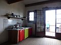
Kitchen in Refuge Ortu di u Piobbu

Refuge Ciottulu di i Mori
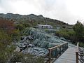
Refuge Manganu

Refuge Petra Piana


Web links
- GR 20 - The cult route in Corsica, Route description on fernwege.de.