 Main hermitage of the wood drift system | ||
| Klausen-Leopoldsdorf | ||
| federal state | Lower Austria | |
|---|---|---|
| Residents | 1.681 (2018) | |
| height | 375 m | |
| Tourist info web | http://www.klausen-leopoldsdorf.gv.at | |
| no tourist info on Wikidata: | ||
| location | ||
| ||

Klausen-Leopoldsdorf is a community in the western Vienna Woods, in the upper reaches of the Schwechat River.
background
The Vienna Woods was not open to the public until the 17th century as an imperial forest and hunting reserve. The nearby city suffered under Emperor Leopold I (r. 1658-1705) Vienna with a considerable lack of fuel. Firewood was difficult to bring into town.
In 1667, a large system of retention basins and locks (the Klausen) to the Holztrift was built on the upper reaches of the Schwechat River. Wood was then flötzt on the Schwechat to Baden and then transported on to Vienna via the Wiener Neustädter Canal. The settlement of the flotters and forest workers, who were settled here from western Austria, was named Leopoldsdorf in der Clauss in honor of the emperor and with reference to the Klausen complex; later changed to Klausen-Leopoldsdorf.
Despite its proximity to Vienna, Klausen-Leopoldsdorf has been little affected by suburbanization to this day.
Districts: The large community consists of the following settlements: Klausen-Leopoldsdorf (main town), Agsbach, Dörfl, Forsthof, Gaisücken, Groß-Krottenbach, Hainbach, Hasenriegel, Hauptbach, Hochstraß, Klein-Krottenbach, Lammerau, Lengbachl, Mitterriegel, Ranzenbach, Schlottleiten, Obergrödl , Riesenbach, Schöpflgitter, Untergrödl
Neighboring communities: Vienna Woods (O), Alland (SO), Altenmarkt an der Triesting (SW), Brand-Laaben (W), Altlengbach (NW), Press tree (N), Wolf pit (NO)
getting there

With public transport
- Regional bus 459 from the train station Swimming above Alland to Klausen-Leopoldsdorf (cemetery) to Hochstraß.
- There is no bus connection from the north and west (Altlengbach, St. Pölten). You have to take the train via Vienna to Baden to reach Klausen-Leopoldsdorf. However, a combination of train and bike is recommended from the Eichgraben-Altlengbach or Rekawinkel stops (see also below).

In the street
The ![]()
![]() Vienna outer ring motorway crosses the municipality:
Vienna outer ring motorway crosses the municipality:
- Coming from the west:
 3 Hochstraß
 - Coming from the east: 15 Alland
And further on country roads.
- Alternative arrival from the south: A2 (Südautobahn) bis 21 Swimming and on via the B 210 to Alland.
- Alternative arrival from Vienna West: A1 (Westautobahn) to 23 Press tree and further via Pfalzau (L 2111)
By bicycle
The state roads through the Vienna Woods are provided with a few inclines, but sometimes with little traffic. From Vienna Liesing, for example, it makes sense to drive through Kaltenleutzüge, Stangau and Gruberau to Klausen-Leopoldsdorf. In combination train-bike, the Eichgraben-Altlengbach stop of the old western railway line (regional trains Vienna Westbahnhof - St. Pölten stop) or Rekawinkel (final stop of the S 50 S-Bahn) are ideal for the journey. There are also some signposted mountain bike routes through the Vienna Woods.
On foot
There are numerous hiking trails through the Vienna Woods that also reach Klausen-Leopoldsdorf.
mobility
The community is large in area and there is practically no public transport. So you have to rely on your own vehicle or on extensive walks in the Vienna Woods.
Tourist Attractions
Klausen-Leopoldsdorf wood drift system


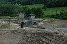

The system of 14 Klausen on the Schwechat and numerous tributaries was built in 1667 under Emperor Leopold I. It was the reason for the establishment of the settlement and its name. Some Klausen were rebuilt from 1756 onwards. They were in operation until around 1940. Numerous clauses, including the imposing main hermitage, have been preserved to this day. Some have recently been renovated to be used as flood retention basins. Some have been torn down, some Klausen have fallen into disrepair and have been partially recaptured by nature:
- The Hauptklause (well preserved) is located right next to the L110 (Klausen-Leopoldsdorf - Alland) about 500 m east of the town of Glashütten.
- That is also preserved Lengbachklause (on the L125 approx. 1 km south of Hochstraß near the village of Lengbachl)
- Riesenbachklause: On the L127 just before the switchbacks at Schöpfl
- Schöpflklause: In Sallygraben, off the L127, only accessible on foot.
More Attractions

- Ranzenbach. The settlement built from 1928 in the Heimat style with beautiful wooden balconies and verandas. In the first few years the settlement was an agricultural commune whose fields, meadows, pastures, tools and livestock were shared.
- Parish church and rectory. Simple late baroque buildings, built around 1780, later partially expanded and rebuilt.
activities
- Vienna Woods Hikes
- Gut Ranzenbach riding school
shop
- There are small grocery stores in Klausen-Leopoldsdorf and Kleinrottenbach
- Leitner bakery
kitchen
- Fahrberger Guest House
- Klausnerhof
- Café cappuccino
- Parlor. At the beginning of the Hochstraß motorway slip road.
- Forsthof guest house. Directly on the municipality boundary to Brand-Laaben.
- Gasthaus Schöpflgitter
accommodation
No accommodations available in the municipality.
health
- Medical center, in Hochstrasse.
- Hospitals in Swimming, St. Polten, Vienna
Practical advice
- Raiffeisenbank, at the main square. With ATM.