
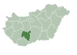
| Tolna County | |
 | |
| location | |
 | |
| Flag | |
 | |
| Main information | |
| Capital city | Szekszárd |
| Currency | forint |
| Surface | 3703 |
| Population | 230 000 |
| Tongue | Hungarian |
Tolna County - county in the central Hungary.
Tolna County is situated in the Transdanubia Uplands. The western and central parts are hilly (Somogy and Tolna hills). The western part, adjacent to the Danube, is flat. The south-eastern edge of the Mezőföld plain belongs to the northern end of this belt, and to the south - the Sárköz marshes. The main rivers of the county are the Danube and its tributaries Sió, Sárvíz, Kapos and Koppány.
Tolna County has existed in more or less the same boundaries since the 11th century.
Geography
Climate
History
Policy
Economy
Drive
By car
By plane
By ship
Cities
Interesting places
Transport
Shopping
Gastronomy
Accommodation
Security
Health
contact
| This is outline article. For now, it includes the article schema and not much else. You can help by supplementing the article with at least basic information, making it useful. |
This website uses content from the website: Tolna County published on Wikitravel; authors: w editing history; Copyright: under license CC-BY-SA 1.0