| Canyon de Chelly National Monument ((in)Canyon de Chelly National Monument ) | |
 | |
| Information | |
| Country | |
|---|---|
| Region | South West |
| Watercourse | Chelly |
| Location | |
 36 ° 9 ′ 17 ″ N 109 ° 25 ′ 46 ″ W | |
| Official site | |
the Canyon de Chelly National Monument is a national monument located northeast ofArizona to United States next to Chinle.
Understand
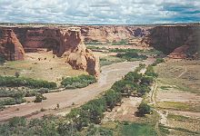
This green and fertile canyon, located in the heart of a landscape of red stones, has been inhabited and exploited for more than 5 000 years by Native Americans Navajo. Even today, Navajo people live in the canyon and use it for their farming and farming activities, in addition to sightseeing and crafts.
To go
As the park is located in an isolated area, the only way to get there is by car.
Since Flagstaff, Take I-40 East, take exit 333 then take US-191 North.
Since Gallup, take US-264 West, then to Ganado continue on US-191 North.
Since Kayenta, continue along Indian Route 59, then take US-191 South.
Circulate
Access to the park is free.
Canyon banks
To access the different viewpoints located on both sides of the canyon, the car is essential. Parking lots are set up in the immediate vicinity of each point of view.
Inside the canyon
Only the troglodyte habitat White house located in the canyon is within walking distance for all visitors. The other places located in the canyon can only be visited by taking a paid guided tour managed by one of the licensed private companies.
To see
- 1 Information center (visitor center) ,

 1 928 674-5500, fax : 1 928 674-5507
  Mon.- Sun. : 8 h - 17 h. – Located at the entrance to the park, the information center provides all the information you need to visit the site, in particular appropriate advice from rangers and a map of the places. A video on the park is broadcast there continuously. A shop allows you to buy documentation and souvenirs.

North Shore
- 2 Antelope House Overlook – View of the canyon and the ruins of the cave dwelling Antelope House named because of the illustrations of antelopes attributed to the Navajo artist Dibe Yazhi who lived there in the early 1800s. Unearthed in the 1970s, this archaeological site dates from the XIVe century has an uncommon circular place in this type of habitat.
- 3 Mummy Cave Overlook – This place offers a view of the troglodyte habitat of Mummy Cave, cave containing one of the largest villages occupied until the 1300s within the canyon. The different alcoves constituting this habitat served as a living space but also as a space for ceremonies. A tower from the end of XIIIe century remains in the central part.
- 4 Cave Overlook Massacre – View of the cave where nearly 115 Navajo Indians had taken refuge during the winter of 1805 to escape the Spanish military expedition led by Antonio Narbona. Discovered by the soldiers, they were killed by shots fired from the shore.
 Inside the canyon

South Shore
- 5 Overlook Tunnel – Viewpoint located at the entrance of a rugged canyon at the end of which you can see the bottom of the main canyon.
- 6 Tsegi Overlook – View of farmland used by the Navajo at the bottom of the canyon.
- 7 Overlook Junction – View over the valley Chinle and the meeting point of the Canyon de Chelly with the Canyon del Muerto.
- 8 White House Overlook – View of an ancient troglodyte village of the Anasazi Indians, on the side and sheltered from the rocks of the Canyon, which was occupied about a thousand years ago. Its current name is due to the long white plaster wall constituting the upper part of the houses.
- 9 Sliding House Overlook – View of the ruins of an ancient settlement built on a smooth surface giving the impression of sliding downwards. The viewpoint is located at a location on the South Rim where vertical cliffs plunge into the canyon on three different sides.
- 10 Face Rock Overlook – View of part of the cliff face resembling a head and the interior of the canyon.
- 11 Spider Rock Overlook – View of the magnificent rocky remnant of slender sandstone from a height of over 240 m, isolated after disintegration due to erosion. This location also offers a view of Black rock butte, remains of an ancient volcano and on the mountains Chuska a background.
 View on Spider rock

Do
Trek
- 1 White House Trail – This trail with a length of 4 km round trip for a drop of 200 m (downhill only on the way out) is the only trail in the park that allows you to descend for free inside the canyon. It allows you to get as close as possible to the ruins of White house, cave dwelling that was occupied about 1 000 years by Native American tribes living there.
 Ruins of White house
 - Discovery with a park guide – The park guides (tidy) regularly organize free tours centered around themes related to archeology, flora and fauna or national events. Information about these visits can be obtained at the Information Center.

Discovery of the interior of the canyon
The interior of the canyon is managed by the Navajo Indians, only the approved companies listed below can organize visits.
- Ancient Canyon Tours , 1 928 380-1563 – Guided tours of the interior of the canyon on foot or in an all-terrain vehicle.
- AZ Canyon Jeep Tours , 1 928 781-2113
 from 75 $ per person. – Company offering several formulas for visiting the interior of the canyon by Jeep: tours lasting 3 or 4 or more 6 h .
 - Beauty Way Jeep Tours , 1 928 674-3772 from 75 $ per person. – Company offering several Jeep tours (3 h or à la carte for a longer period) as well as hikes with or without overnight camping.
- Canyon Ancient Jeep Tours , 1 928 255-9426, e-mail : [email protected] – Visit of the interior of the canyon in an all-terrain vehicle carried out by the family of a Native American shaman.
- Canyon de Chelly Horseback Tours , 1 928 674-5678 – Visit of the canyon on horseback.
- Canyon de Chelly Tours , 1 928 349-1600 from 75 $ per person. – Tours of the canyon in an all-terrain vehicle accessible to people with reduced mobility.
- Canyon Hawk Tours , 1 928 797-8415 – Canyon tours by all-terrain vehicle or on foot.
- Justin's Horse Rental , 1 928 675-5575, e-mail : [email protected] Mon.- Sun. : 7 h - 19 h. 15 $ per hour and per person 15 $ per hour for the guide. – Visit the interior of the canyon on horseback or on foot.
- Speaking Rock Tours , 1 928 781-2016 – Visits on foot or in an all-terrain vehicle, with the possibility of spending the night camping in the canyon.
- Tseyi Jeep Tours , 1 928 674-3262 of 150 $ To 350 $ the visit, depending on the duration and number of participants. – Visits to the interior of the canyon in an all-terrain vehicle. Two options are available: a tour lasting 3 h and a tour lasting 5 h , each limited to 6 people.
- Thunderbird Lodge Tours , 1 928 674-5842, e-mail : [email protected] of 70 $ To 140 $ per person. – Visit of the canyon in an all-terrain vehicle. Two options available: a visit to 4 h and a day visit lasting 8 h , including the canyons of Chelly and del Muerto.
- Twin Trails Scenic Tours , 1 928 349-5560 – Visits inside the canyon on foot or in an all-terrain vehicle.
To buy
- Information center (visitor center) – Located at the entrance to the park, the information center (section To see) has a sales area where it is possible to buy souvenirs, postcards and books.
- – It is possible to buy handicrafts made within the park by the Navajo Indians on the parking lots from every point of view of the park.
- Other businesses – The city of Chinle located in the immediate vicinity of the park has an important commercial offer.
Eat
- 1 Thunderbird Lodge Restaurant – The restaurant occupies the premises of a trading post built in 1896 and serves Native American and American cuisine throughout the day.
Have a drink / Go out
Within the grounds of the park, it is only possible to have a drink in the restaurant mentioned in the section Eat.
To go out or enjoy a bar, it is possible to leave the park and go to the city of Chinle, located close to the entrance to the park.
Housing
The accommodation offer within the park is reduced due to the immediate proximity of the town of Chinle which has a substantial hotel offer.
Camping
- 1 Cottonwood Campground , 1 928 674-2106 14 $ by night. – Campsite made up of 93 pitches spread over 4 areas, with toilets and sinks (but no shower).
- 2 Spider Rock Campground , 1 928 781-2016 of 11 $ To 16 $ location per night. – Campsite with 30 pitches for tents and motorhomes as well as traditional huts (hogan) located in the heart of the canyon.
Hotel
- 3 Thunderbird lodge Bia Indian Route 7, Chinle, AZ 86503, 1 800-679-2473 of 69,99 $ To 99,99 $ the night. – Hotel located on the site of a former commercial counter. The rooms have air conditioning, satellite TV, coffee maker, hairdryer and ironing board and free wireless internet. Parking is free.
Around
- 1 Chinle – Town located at the entrance to the Park.
- 2 Monument valley – Famous for its stone columns, this park has been the location of many westerns.
- 3 Hubbell Trading Post National Historic Site – Commercial counter built at XIXe century still in operation today.
- 4 Petrified Forest National Park (Petrified Forest National Park) – Forest of wood petrified by sand.
- 5 Four Corners – The only location in the United States where four states meet.