| Colorado National Monument ((in)Colorado National Monument) | |
 | |
| Information | |
| Country | |
|---|---|
| Region | American Rockies |
| IUCN Category | III (Natural monument) |
| Area | 83 km² |
| Location | |
 39 ° 2 ′ 33 ″ N 108 ° 41 ′ 10 ″ W | |
| Official site | |
the Colorado National Monument is a natural space located in the state of Colorado to United States of America.
Understand
Colorado National Monument is a natural space made up of canyons and plateaus. The elevated plateaus offer panoramic views of distant horizons while the remote canyons allow a feeling of deep isolation. Many wildlife reside in this area, especially bighorn sheep, coyotes, mountain lions and golden eagles. There are also cacti, junipers, pines and a whole specific flora. When at the start of XXe century, John Otto, a staunch defender of the natural heritage, discovered this place, he traced the first path there and planted the American flag atop the tallest monolith he found. He fought for this space to be classified as a natural monument, which was done in 1911.
To go
The Park is located near the town of Grand Junction. The information center is located near the West Entrance toll gate. It is therefore advisable to travel the Park from West to East.
Entrance fee
As with any National Park, an access fee is charged at the entrance. He wakes up at 10 $ per vehicle for a period of 7 days consecutive. It is also possible to acquire and use the card America the Beautiful at the price of 80 $ which gives access to all United States National Parks for a period of one year.
By car
The I-70 motorway leads to the Park by taking exits 19 (Fruita, exit recommended for visiting the Park) and 31 (Horizon Drive).
- 1 West Entrance Toll Gate (Fruita) – To 19 km of Grand Junction and to 19 km of Fruita and exit 19 of route 70
- 2 East Entrance Toll Gate (Grand Junction) – To 6 km of Grand Junction
By plane
- 3 Grand Junction Regional Airport (Grand Junction Regional Airport) – Many domestic routes from Allegiant, American Airlines, Delta Airlines, United Airlines and US Airways serve this airport.
By train
- 4 Amtrak 339 S 1st St, Grand Junction,
 1 800 872-7245 (free number) – Train line California zephyr serves the city of Grand Junction.
A bicycle
It is possible to cycle only the road Rim Rock Drive crossing the Park, respecting mandatory safety rules. In particular, it is compulsory to have lighting and to drive in single file.
By taxi
- 5 Grand Junction Visitor and Convention Bureau 740 Horizon Drive, Grand Junction, 1 970 244-1480 – Local tourist office offering many services including the reservation of taxis.
By public transport
- 6 Grand Valley Transit 525 S. 6th Street, First Floor, Grand Junction – This company does not directly serve the Park but the Grand Junction area.
Circulate
By car or bicycle
The road Rim Rock Drive crosses the Park from East to West. It is the only axis authorized for cars and bicycles.
Walk
The Park is not designed to be traveled entirely on foot. However, the many hiking trails allow you to practice walking.
To see
Duration of visit
Half a day allows you to explore the entire Park by car while stopping at the various viewpoints. At the end of the day, the lighting particularly highlights the rocks and canyons.
If you have more time, it is interesting to browse the hiking trails that allow you to enter the canyon and thus to admire it from another angle.
If we have less time, we must privilege the points of view Balanced Rock, Fruita Canyon, Independence Monument, Grand View and Rec Canyon.
Information center
- 1 Saddlehorn Information Center (Saddlehorn Visitor Center)
 In summer 8 h - 18 h. – This information center has maps and brochures for exploring the Park. The rangers are present to provide advice and information on the various activities offered. Educational exhibits allow you to learn more about the Park, as well as two films lasting 12 mins each.
Panoramas
- 2 Redlands View – From this point of view, we can clearly see a fault in the earth's crust which was particularly active 40 to 70 million years ago.
- 3 Balanced Rock View – View on Balanced Rock, large rock that seems to be in unstable balance.
- 4 Historic Trail View – Built by local breeders in the 1880s, the path that can be seen from this point of view from the opposite canyon has made it possible to trace a route allowing the transhumance of herds. However, it took several days (and nights) to cover the entire trail. In 1907, it was improved to carry pipes for building an aqueduct supplying the valley floor. Today this trail is intended for hikers.
- 5 Distant View – This location allows you to enjoy a panorama of the valley with the Colorado River in its center.
- 6 Fruita Canyon View – Canyon view Fruita below in which the road winds through the Park.
- 7 Independence Monument View – View on Independence Monument, emblematic monolith of the Park that John Otto climbed to plant the American flag, a tradition that continues to this day on Independence Day on July 4.
 Independence Monument
 - 8 Book Cliffs View – This point of view is located along a short path, it allows to see the surrounding cliffs.
- 9 Grand View – View of the cliffs and monoliths constituting the main canyon of the Park, with the valley and the river in the background Colorado.
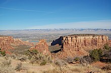 Grand View
 - 10 Monument Canyon View – Canyon view Monument with the valley in the background.
- 11 Coke Ovens Overlook – View of geological formations due to erosion, which are shaped like ovens in which coal was placed to transform it into coke, a material which produces very little gas when it burns.
- 12 Artists Point – View of the canyon offering a very colorful landscape.
- 13 Highland View – View of the widest part of the Park, with its canyons clearly visible below.
- 14 Upper Ute Canyon Overlook – Point of view on the Ute canyon, whose name is that of a tribe who lived in this place.
- 15 Fallen Rock Overlook – View of the rock formation of the same name.
- 16 Ute Canyon Viewpoint – Point of view on the Ute canyon, with explanatory panels on the formation of this canyon by successive floods.
- 17 Red Canyon Overlook – View of a very particular canyon, since at the bottom of it, in the shape of a rather wide U, is another canyon, in the shape of a V, narrower.
 Red canyon
 - 18 Cold Shivers Pointview – Canyon view Columbus, whose rocks are grayer than in the rest of the Park.


Do
Trek
- 1 Black Ridge Trail – Three access points: (1) in front of the Visitor Center North. (2) accessible by C.C.C. Trail To 6,1 km east of Visitor Center by the path on the right. (3) and to 10,3 km east of Visitor Center by the path on the left; you can also access the Liberty Cap Trail by this path. Long 8,8 km, medium difficulty, average duration of 3 h. Higher trail in the park with unobstructed views west to the canyon areas of Utah, east to Grand Valley, and south to the San Juan Mountains. Follows the leveling of the land Black ridge. the route crosses the space of McInnis Canyons National Conservation.
- 2 Canyon Rim Trail (Starts behind the Visitor Center and ends at the panorama Cliffs View) – 0,8 km, easy difficulty, medium duration 30 min. Path following the edge of the cliff. Exceptional view for the landscape and the fauna.
- 3 Alcove Nature Trail (Directly in front of Visitor Center.) – 0,8 km, easy difficulty, average duration 30 min. Trail that leads into an alcove in a canyon: Detailed descriptions are available at the trailhead and at the visitor center. A good introduction to some of the plants, animals and rocks of the monument. Ideal for families with children.
- 4 Otto's Trail (From Visitor Center, turn left on Rim Rock Drive and continue 1,6 km at the start of the trail on the left.) – 0,8 km, easy difficulty, average duration 30 min. Gently sloping path that leads through edulis-juniper woods to a belvedere with a view of Sentinel Spire, Pipe Organ, Praying Hands, and Independence Monument.
- 5 C.C.C. Trail (From Visitor Center, turn left on Rim Rock Drive and continue 6,1 km. The trail is on the right - look for the notice board. Continue further and park in the parking lot on the left.) – 1,2 km, moderate difficulty, medium duration 1 h . It is one of the three routes to which join Black Ridge Trail. It is also used to attach the Black Ridge Trail with the Monument Canyon Trail.
- 6 Coke Ovens Trail (From Visitor Center, turn left on Rim Rock Drive and continue 6,1 km at the start of the trail on the left) – It is also the start of the trail for Monument Canyon Trail. 0,8 km, easy to diffuse, average duration 30 min. The route gradually descends and runs parallel to the hill leading to the viewpoint. Look on the rounded beds Coke Ovens, an illustration of the effects of the weather and the weather on the ground of Wingate.
- Monument Canyon Trail – Two access points: (1) from the starting point of the Cook Ovens Trail and (2) from the monument's west toll station, turn right onto route 340 and after 3,4 km turn right just beyond point 5 onto a dirt road that appears to be a driveway; continue 0,2 km at the start of the trail. Length 6,7 km, moderate to steep difficulty, medium duration 4 h . From the top point, step 180 meter down the plateau into Colorado National Monument where you can walk past many of the park's large rock carvings: Independence Monument, Kissing Couple, and the Coke Ovens.
- 7 Liberty Cap Trail – Three access points: (1) from the west toll agreement, turn right on route 340 and continue 10,5 km then turn right at the traffic lights onto South broadway, continue 1,9 km and turn left on Wildwood drive, from this point to roll 0,8 km and watch closely for a brown trail sign on the right to what appears to have gone; turn in this lane to the trailhead. (2) from the East Toll Station, drive north on Monument Road 1,0 km and turn left on South Camp Road; roll 4,2 km until its junction with South broadway; turn left during 0,8 km; turn left on Wildwood drive and roll 0,8 km; watch closely for a brown trail sign on the right to what appears to have gone; turn in this lane to the trailhead. (3) from Visitor Center, turn left on Rim Rock Drive and roll 10,3 km at the start of the trail on the left. This access point is shared with Black Ridge Trail. Access points (1) and (2) are shared with Ute Canyon Trail and Corkscrew Trail. 11,3 km, easy course and containing very steep sections, average duration of 4 or 5 h .
- 8 Ute Canyon Trail – Three access points: (1) from Visitor Center, turn left on Rim Rock Drive and roll 15,0 km at the start of the trail on the left, (2) from the monument west toll station, turn right onto highway 340 (east); after 10,5 km, turn right at the traffic lights onto South broadway; Continue 1,9 km and turn left on Wildwood drive; watch closely for a brown trail sign on the right, at 0,8 km turn onto the road to the trailhead; (3) from the east toll plaza, continue north on the Monument Road1,0 km, turn left on South Camp Road; to roll 4,2 km until its junction with Model: Lng; turn left and after 0,8 km turn left on Wildwood drive and continue on 0,8 km; watch closely for a brown trail sign on the right to what appears to have gone then turn in that lane to the trailhead. The last two access points are shared with the Liberty Cap Trail and Corkscrew Trail. difficult difficulty, 11,3 km average duration 4 to 5 h . Difficult and narrow descent from the plateau because follows a primitive track. The course then follows the stream with the current and swimming pools bordered by poplars and seasonal willows. Some arches can be seen. unmaintained route.
- 9 Serpent's Trail (From the entrance to the east toll plaza, drive 0,3 km. Limited time parking is on the left. For longer parking, turn right into the picnic area.) – 2,8 km, difficulty due to the presence of stairs. Duration approximately 1 hour. Called "the world's most twisty road," this historic trail has 16 bends. The trail climbs steadily from east to west through the rocks of Wingate. Built in the early 1900s, this road was part of the main road until 1950.
- 10 Devil's Kitchen Trail (TO 0,3 km from the east toll station. Limited parking is on the left. For longer parking, turn right into the Picnic Area.) – The start of the trail is shared by two other trails: No Thoroughfare Canyon Trail and Old Gordon Trail. Access to Snakes Trail is on the road. 1,2 km, moderate difficulty, average duration of 1 hour. Gradual ascent towards a circular natural opening formed by enormous vertical rocks. At the first fork, go right. At the second fork, turn left. Follow the trail through the wash. The further you go into the canyon you will see the large rock cave which is the Devils Kitchen. Continue on the established trail and follow the steps carved into the rock. As you approach the base of the rock formation, go left around it and walk into the opening in the rock.
Escalation
It is possible to practice climbing within the Park, outside the protected areas, by respecting the rules published by the National Parks Service. The companies listed below are approved to organize climbing sessions within the grounds of the Park.
- APEX Mountain School 51 Eagle Road, # 1, Avon, 1 970 949-9111
- Colorado Alpine and Desert Adventures PO Box 2803, Grand Junction, 1 970 245-8513
- National Outdoor Leadership School 502 Lincoln Street, Lander, 1 307 332-9900
- Peak Mountain Guides PO Box 1025, OUray, 1 970 325-7342
To buy
- 1 Saddlehorn Information Center (Saddlehorn Visitor Center) In summer 8 h - 18 h. – The information center is the only place in the Park where it is possible to make purchases. It has a souvenir shop and a bookstore.
Eat
There is no restaurant within the Park, but the town of Grand Junction, in the immediate vicinity, offers many possibilities of restoration.
Picnic
- 1 Book Cliffs Picnic Area
- 2 Devil's Kitchen Picnic Area –

Have a drink / Go out
The Park does not have a restaurant or bar. The city of Grand Junction however offers all amenities in the immediate vicinity.
Housing
Camping
- 1 Saddlehorn Campground 1750 Rim Rock Drive, Fruita, 1 970 858-3617to be released before 11 h.
 20 $. – The only campsite located within the grounds of the Park, it has a zone of pitches allocated to first arrivals and a second zone whose pitches can be reserved up to 6 months in advance. It is equipped with toilets, running water is available there in summer. Each location has a picnic table, charcoal barbecue and parking area.
Around
- 1 Black Canyon of the Gunnison National Park – A very deep and very narrow canyon at the bottom of which flows a river with a very important flow.
- 2 Dinosaur National Monument – Numerous dinosaur fossils, petroglyphs and a scenic drive in this space located in the middle of the desert on the border of Colorado and Utah.