| Northern canadian | |
 | |
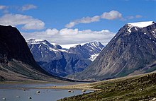
| North East Coast of Baffin Land | |
| Information | |
| Country | |
|---|---|
| Area | 3 925 756 km² |
| Population | 107 512 hab. |
| Density | 0,03 inhab./km² |
| Telephone prefix | 1 |
| Location | |
 76 ° 24 ′ 0 ″ N 107 ° 6 ′ 0 ″ W | |
the North from Canada is a subarctic and arctic region grouping together the three Canadian territories: the Yukon, the Northwest Territories and the Nunavut. Very sparsely populated, with large wilderness, exceptional flora and fauna and immense natural resources, this region is also the ancestral land of the Inuit and several First Nations (Amerindians).
Understand
The Canadian North is a very large region covering different environments, ranging from the boreal forest to the mountains and from the subarctic climate to the arctic climate. It is one of the most remote places in the world, but, make no mistake, people live there. Travel in Canada's North is difficult and expensive. The majority of people visit it during the summer when the territories are not plunged into almost constant darkness, snow and sub-freezing temperatures. No matter the season, visiting Canada's North is a remarkable and unforgettable experience!
Territories
.png/450px-Canada_north_map_(fr).png) Map of Northern Canada |
|
Cities

- 1 Dawson city – The former capital of Yukon and the city of the "gold rush".
- 2 Iqaluit – The capital of Nunavut.
- 3 Inuvik – The midnight sun during 56 days and the polar night during 30 days.
- 4 Whitehorse – The capital of Yukon.
- 5 Yellowknife – The capital of Northwest Territories.
Other destinations
- 1 Auyuittuq National Park
- 2 Kluane National Park (Kluane National Park and Reserve)
- 3 Nahanni National Park Reserve
To speak
The languages spoken in the Canadian territories are English and French.
However, the Nunavut, in addition to English and French, has two other official languages: Inuinnaqtun and Inuktitut. It is the only territory with four official languages.
To go
Circulate
Itineraries
- 1 Dempster Highway (Dempster Highway)
To buy
Eat
Have a drink / Go out
Security
Around
Canada's North borders on the rest of Canada to the south, to theAlaska west and Greenland to the East.