East Kazakhstan region - Obwód wschodniokazachstański
East Kazakhstan region

East Kazakhstan region
|
 |
| location |
 |
| Main information |
| Capital city | Ust-Kamienogorsk |
|
| Currency | tenge |
| Surface | 283 300 |
| Population | 1 393 932 |
| Tongue | Kazakh, Russian |
|
|
| Code | 7 (722), 7 (723) |
|
|
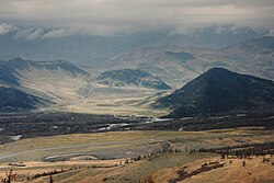
East Kazakhstan region - circuit in the eastern part Kazakhstan with an area of 283,300 km² and a population of 1,442,000 inhabitants. Its capital is Ust-Kamienogorsk. It borders on the north with Russia, from the northeast with China, from the northwest with Pavlodar region, from the west with Caraganda region and from the south with Almaty region. The greatest part is occupied by the Altai ranges (in the north-eastern part the highest peak, Belukha, 4506 meters). The climate of the region can be described as moderate, remarkably continental. There is a dense network of rivers (Irtysh and its tributaries). The economy is based on mining and metallurgy of non-ferrous metals (lead, zinc, copper, titanium), and the cultivation of cereals and breeding also play a significant role. Hydroelectric power plants are located on the Irtysh.
Characteristic
Geography
Climate
History
Policy
Economy
Drive
By car
By plane
By ship
Regions
Cities
Interesting places
Transport
Shopping
Gastronomy
Accommodation
Security
Health
contact


