This article covers the North flank of the Olympus massif North of Greece.
background
The Olympus massif rises in the south of Macedonia on the border to Thessaly and is particularly impressive due to its proximity to the sea level of the Thermean Gulf. This fact, and the fact that the peaks are often overcast when the sun is shining in the rest of Greece, led to Olympus being regarded in Greek mythology as the abode of the gods. Where else could the thunderbolt, the father of gods Zeus, have his throne than on the summit of Stefani? When the gods really let it crack in anger on Mount Olympus, their arguments in the valley were taken as a storm.
history
In antiquity, people shied away from climbing the impassable mountains, although offerings for the twelve Olympian gods were made on the summit of Agios Antonios, as archaeological finds show.
In modern times, the French L. Heuzey, the German H. Barth attempted the ascent, the German E. Richter was prevented from climbing the summit by brigands. It was only after the region was liberated from Ottoman rule that the Swiss F. Boissonnas and D. Baud-Bovy managed to get out under the leadership of Christos Kakalos Litochoro the first ascent of the highest peak Mytikas.
Lately, numerous hiking routes and paths have been marked and a whole network of mountain huts is operated in the summer and autumn season.
landscape

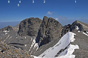
The Olympus massif rises practically from sea level and is therefore extraordinarily imposing, but Olympus is really the highest mountain range in Greece. The shape of the entire massif resembles a horseshoe around the valley of the Enipeas, which leads to the starting point of the tour to Prionia. On the north flank there are several parallel resp. radial gorges with streams that carry water in some cases even in summer.
In addition to the main route via Litochoro In the Enipeas Gorge to Prionia and from Olympiada from the south there are also various access options from the north flank into the massif.
Flora and fauna
The core area of the Olympus massif was placed under protection as early as 1938, which expanded Protected area has since been expanded to 24,000 hectares.
In the Olympus massif there are 1700 plant species mainly from the Mediterranean flora, with the Jankea heldreichii a total of 23 locally endemic species that are only found in the Olympus massif. The flora includes an enormous variety due to the altitude from the Mediterranean coast at the foot of the massif to the high mountain flora above the tree line.
32 mammal species live in the Olympus massif, among the largest are chamois, deer and wild boar after the last bear was shot in 1980 - in ancient times there were reports of lions that no longer cross the path of hikers today. Among the hundred bird species there are numerous birds of prey to be mentioned, as well as insects, butterflies, but also the more unpleasant winged creatures such as horseflies.
climate
At the foot of the mountain massif, on the beach of the Thermean Gulf, you can enjoy the hot Mediterranean climate in summer, but the clouds that form on the slopes due to the temperature differences lead to precipitation all year round, which feed the springs around the massif and keep this part of Greece green in summer. With increasing altitude you get into an alpine climate. In order to reach the summit, which is just over 2900 m high, the snow must first have melted in May, and sometimes the hiking trails to Mytikas are not definitively opened until June after snow falls.
getting there
&groups=Maske,Track,Aktivitaet,Anderes,Anreise,Ausgehen,Aussicht,Besiedelt,Fehler,Gebiet,Kaufen,Kueche,Sehenswert,Unterkunft,aquamarinblau,cosmos,gold,hellgruen,orange,pflaumenblau,rot,silber,violett)
Those who arrive by plane are most likely to use the one about 120 km away Thessaloniki Airport![]()
![]()
![]() (IATA: SKG) and in just under an hour and a half by rental car you can get to what is often the starting point for Olympus tours Litochoro.
(IATA: SKG) and in just under an hour and a half by rental car you can get to what is often the starting point for Olympus tours Litochoro.
The railway line Thessaloniki–Athens leads along Olympus. The »Prostiakos« trains between Thessaloníki and Lárisa, which run every two hours, stop at all access points. Litochoro has its own train station, it is located about 2.5 kilometers from the center on the coast. It is also possible from Katerini a bus to Litochoro to use. Railways and bus companies are fierce competitors in Greece, the timetables and access points are not coordinated.
The easiest way to get there, especially if you use alternative access routes from the north, is by private vehicle. From the toll motorway A1, which runs east of the Olympus massif in north-south direction, the region is best reached via the exits ![]() Litochoro or
Litochoro or ![]() Dion Museum (for the north access).
Dion Museum (for the north access).
Fees / permits and regulations
There is no charge for access to the park.
For the stay in Olympus National Park there are clear rules of conduct:
- the entry in the national park is only in the time of sunrise to sunset on the officially designated paths allowed.
- Young people under 14 years of age are only allowed to visit the national park when accompanied by an adult.
- Park is only permitted in the area of the signposted parking spaces.
- It is forbidden Pick, Dig up, destroy of plants and trees and collecting seeds
- That is forbidden hunt on all animals throughout the year (in the core area), disturbing birds and taking eggs or young animals with you
- Damage to geological formations, including the collection of stones, is prohibited
- It is forbidden to let pets run freely (dogs must be on a leash).
mobility
In the Olympus massif itself, you move on foot, mountain hiking experience is an advantage. The ascent of the Skala summit is easily possible for anyone with mountain hiking experience, in order to conquer the main summit, Mytikas, which is a few meters higher, climbing skills (level of difficulty II, three-point posture, safety rope only for inexperienced) are necessary.
In addition to the normal hiking routes, there are also via ferratas with high levels of difficulty.
The access routes are partly paved, then continue as gravel roads, which can only be used by vehicles with good ground clearance, possibly four-wheel drive and off-road vehicles, respectively. appropriate motorcycles can be ridden.
Tourist Attractions


Access via Dion
Ourlias Gorge / Koromilia
- from one 1 Spinning top to the west of Dion the paved arterial road marked with »»λυμπος / Olympus« is to be used.
- after a few switchbacks you reach the little church 1 Agios Konstantinos with the separately standing bell tower consisting essentially of four tree trunks. In front of it there is a water point, fed by the water from the Ourlias river.
- The asphalt road ends here, the parked vehicles show that there is something to see here.
- a gravel road leads a few hundred meters into the valley, to the right there are trails leading to the stream Ourlias into the canyon bottom. There are several in the course of the Ourlias water falls and bathing spots with crystal clear water, daring Greeks jump into the deep pools.
- the marked Hiking trail Agios Konstantinos - Koromilia Refuge (blue triangle) leads from the hairpin into the undergrowth and leads to the Koromila mountain hut and from there on to Olympus. For the distance to Koromilia (4.5 km, 870 m difference in altitude) the time required according to the information on the topographic map is about two hours; People who are used to the mountains will be faster.
- the Gravel road leads in numerous serpentines up to Koromilia mountain hut, an information board at the beginning of the gravel road informs you whether it is open.
Koromilia Refuge / Petrostrouga

- from there a yellow marked hiking trail leads up to Petrostrouga mountain hut (4.75 km, 975 m difference in altitude) and from there on to the Skourta summit.
- from the Petrostrouga refuge is the 2 Ithakisios Cave (Σπηλιά Ιθακήσιου), the painter Vasilis Ithakisios once lived in the grotto.
Petrostrouga / Plateau of the Muses

- Via the Yosospass (Giosospass) you can continue to the Muses Plateau / Plateau of the Muses with the Refuge C / Refuge Christos Kakalos (from Petrostrouga 5.7 km, 860 m difference in altitude).
- the Giosos pass (Πέρασμα Γιώσου) was expanded a little and secured with steel cable and is now easy to walk in summer.
- after that one achieves that Plateau of the Muses (Muses Plateau, Οροπέδιο Μουσών), the level below the highest peaks of the Olympus massif, here is not only the Ch.-Kakalos refuge (Refuge C, Ch. Kalakos Refuge) but also a little to the northwest the Giosos Apostolidis refuge of the mountaineering club of Thessaloniki.
- 1 Koromilia Dion Refuge. Tel.: 30 23520 83000 (Olympus National Park Management Agency), 30 23513 51000 (Dion Municipality), 30 6945661104 (Dimitris Paralykides), Email: [email protected]. 20 beds.
- 2 Petrostrouga Refuge. Tel.: 30 23520 83000 (Olympus National Park Management Agency), 30 23523 50100 (Municipality of Litochoro), 30 2310 310649 (Hellenic Rescue Team), 30 6977 246350 (N. Parmakis), Email: [email protected]. 80 beds, restaurant, helipad; operated by the Hellenic Rescue Team.Open: in winter on weekends, in summer open daily.
- 3 Refuge Christos Kakalos. Tel.: 30 6937 361689, Email: [email protected], [email protected]. 25 beds, food, toilets. The refuge at 2648 m is named after the Olymp leader and first Greek climber, Ch. Kakalos.Open: open mid May – Oct. as well as December – mid-April.
- 4 Refuge SEO Giosos Apostolidis. Tel.: 30 23510 82840, 30 6932 367998, 30 2310 224710. 80–100 beds, restaurant, toilets; the highest refuge at 2700 m is operated by the Thessaloniki Mountain Club (SEO of Salonica). From here ascent to the summit Profitis Iliad (Prophet Elias, 2788 m) and Touba (2801 m) possible.Open: open approx. Mid-June – end of September.
Access via Vrontou (Βροντου)
- from the central 2 Roundabout in Vrontou The access road to the starting point of Olymptouren branches off from north to south and is with Ολυμπος (Olympos) and the name of the churches Αγ. Τριαδα (Ag. Triada) and Αγ. Κορη (Ag.Kori) called.
- the 3 Olymp access The access road to Olympus is marked with a blue sign with the churches mentioned and a brown sign "Olymp" at the end of the village.
- in the 3 Chapel of Agii Apostoloi the road forks, brown signs point the way to the left Church of Ag. Kori and right to Ag. Triada, an information board provides information about the tours starting here.
- at the 4 Olympos Recreation Park there are parking spaces and picnic tables.
- a little further to the north-west lies the 5 Agios Nikolaos Church at the ruins of the old village of Vrontou.
Agia Kori - Kopanoula - Petrostrouga
- the paved road ends at the church of Agia Kori (Αγ. Κορη) at a parking lot.
- A path leads through an archway to the one on a picturesque watercourse 6 Agia Kori Church.
- the one with a red circle The marked path initially runs along the watercourse of the Ag.-Kori river and then climbs up to Kopanula, where the gravel road is crossed. Via Elatos Col the path reaches Petrostruga with the Petrostrouga Refuge. (10.2 km, 1820 meters in altitude, approx. 6 hours, of which 4 hours to Elatos Col / Diaselo Elatos and two more to Petrostrouga).
Agioi Apostoloi - Mastorouli - Elatos Col - Kleftovyrsi Spring
- the one with one too red circle marked path runs from the Chapel of Agioi Apostoloi along the bends of the gravel road to 7 Source Mastorouli (Μαστορουλι) (dry in summer), from there ascent to Elastos Col; from there optional descent to the Kleftovrysi spring (Κλεφθοβρυση), retreat of the brigands in the Olympus area during the Ottoman rule. The path ends here. (7.7 km, 1360 m difference in altitude, approx. 3 - 5 hours)
- As an alternative to the way back on the same path, you can hike back to the starting point on the last route from Elatos Col via Kopanula and the path along the Ag.-Kori river.
Agioi Apostoloi - Agia Triada - Kravatia Refuge
- of the Chapel of Agioi Apostoloi as a starting point initially rise to 8 Church of Ag. Triada (also has a driveway)
- then further rise to Krevatia Refuge (3.6 km, 600 m difference in altitude, approx. Two hours; marking yellow square with red border).
Krevatia Refuge - Barbalas - Muses Plateau
- good road conditions on the ascent Barbalas
- then worse road conditions and difficult route finding for the Ascent to the Plateau of the Muses with difficulties on the last section of the route! Clarify accessibility beforehand, take a hiking map and, if necessary, a hiking avi with you (8 km, 1700 m difference in altitude, 6 - 8 hours; marked yellow circle with red border)
Krevatia Refuge - Papa Rema
- Possibility to continue the hike from Krevatia
- Descent into the valley of Papa Rema (Marking turquoise circle with yellow border, 2.9 km, 133 m difference in altitude, one hour for this route)
- There the hike continues back to the starting point along the Papa Rema valley or ascent to Papa Aloni and the Mastorouli spring.
Agioi Apostoloi - Papa Rema - Papa Aloni - Mastorouli
- From the starting point at the Agioi Apostoloi chapel, the path follows the river valley of Papa Rema
- from a height of 820 m (fork with path from Krevatia Refuge) the path climbs steeply in hairpin bends by approx. 250 m to the height of Papa Aloni
- from there past Tsirknia and descent in the direction of Agia Kori gorge to Source Mastorouli (Marking red circle, yellow border; 10 km, 1200 m altitude difference, 4 - 5 hours to get here)
- from the Mastorouli spring there is still the descent to the starting point on the footpath or the bends of the gravel road before.
- 5 Krevatia Refuge. Tel.: 30 23520 83000 (Olympus National Park Management Agency), 30 6978 278548 (Hut warden). 20 beds, open on weekends.
activities
- hike and climbing, sometimes mountain biking on the gravel slopes
- You can swim in the Ourlias Gorge
- Visit of the different churches (Ag.Triada, Ag.Kori)
shop
- Everything that is needed for an Olympus tour (including mountain equipment) can be found in the often chosen tour starting point Litochoro be procured in Dion there is a small supermarket for everyday needs.
kitchen
accommodation
Hotels and hostels
Camping / overnight stay in a hut
- Free camping is prohibited in the entire national park area, the campsites on the Olympic Riviera are within a short driving distance.
- in quite a few Mountain huts (see above) can be stayed overnight
Practical advice
- Information is provided by Information point at the entrance to Litochoro to Prionia, Here information is provided about route difficulties and the accessibility / opening of the various routes (Greek, English). A short stop is worthwhile before every tour.
Important phone numbers:
- Olympus National Forest Park Administration, Litochoro, Tel. 30 23520 83000, Fax. 30 23520 83974 resp. email [email protected] (answers to inquiries in English were assured)
- Forestry Directorate Pieria, Katerini: 30 23510 45470
- Elassona Forestry Office 30 24930 22243
- Litochoro Forestry Office 30 23520 81042
- in Litochoro can leader be hired for mountain and climbing tours.
security
In the Olympus massif one moves in the high mountains, before a tour one informs oneself at the information point, on hiking maps about the contact telephone numbers of the nearest offices of the rescue organization (back of the hiking map) and the location of the refuges.
The weather can change quickly, even if you have sweated on the beach at 36 ° C, a storm with hailstorms can brew up at an altitude of almost 3000 m, consult the weather report and always carry bad weather clothing with you.
trips
- to Prionia resp. the eastern access to the Olympus massif
Web information
- Website of the National Park Administration, Greek, Engl.
- Information about the refuges in the Olympus massif on the website of the park administration, engl.
- Overview maps can be downloaded from the park administration's website, useful for preparing your trip
literature
- Hiking map Topo25, 1: 25,000, ΟΛΥΜΠΟΣ / Mt. Olympus, Anavasi, www.anavasi.gr, approx. € 5.00