Today as Omaha Beach well-known stretch of coast in the department Calvados owes its name to the Allied landing forces in World War II. The code designation at that time has since become naturalized. To the west of Omaha Beach is the 30 m high cliff Pointe du Hoc.
places
- Grandcamp Maisy
- Vierville-sur-Mer
- Saint-Laurent-sur-Mer
- Colleville-sur-Mer
- Sainte-Honorine-des-Pertes
- Port-en-Bessin-Huppain
- La Cambe
Other goals
- Pointe du Hoc at Grandcamp Maisy
- American War Cemetery and Bay at Colleville-sur-Mer
- German military cemetery at La Cambe
background

Allied troops landed on June 6, 1944 (D-Day) on five stretches of the Normandy coast, which they gave the code names Utah Beach, Omaha Beach, Gold Beach, Juno Beach and Sword Beach gifts. The entire strip of land covers about 100 km of coastline. The code names were adopted in general usage and can also be found on signposts, for example.
The Pointe du Hoc is a high plateau whose 30 m high rock faces drop vertically into the sea. It was of particular interest to the German Wehrmacht's Atlantic Wall due to its strategically advantageous location. Six 155 mm cannons with associated anti-aircraft and machine-gun positions were stationed here, with which Utah Beach and Omaha Beach could be completely controlled. The Pointe du Hoc does not belong to any of the five major landing sections. On the morning of the D-Day it was stormed in a spectacular operation by a US special unit, which climbed the cliff walls with throwing anchors and rope ladders with great losses. The site was left almost unchanged after the war and can be visited today.
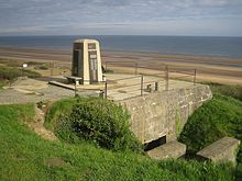
About 5 km east of Point du Hoc begins the 15 km long Omaha Beach. It ends at Port-en-Bessin-Huppain. In contrast to the other landing beaches, the terrain here rises steeply from the beach. After the approximately 50 m high steep step, the landscape is flat to slightly hilly. The Allies only succeeded in capturing Omaha Beach after long and very loss-making battles. The monumental American military cemetery and the well-preserved German positions near Colleville-sur-Mer form a tourist center.
language
Due to the large number of English-speaking visitors, communication in English in the tourist centers is generally problem-free.
getting there
The D514 connects the coastal towns with each other. The Route National N13 runs about 10 km inland parallel to the coast. It connects Caen above Bayeux With Cherbourg-Octeville.
mobility
Public buses run on the D514 coastal road. Having your own vehicle makes a lot of things easier.
Tourist Attractions
- Point you hoc. Largely preserved German position with cannon bunkers. Excellent vantage point over the ocean and with good visibility over to Utah Beach. The closer Omaha Beach cannot be viewed directly. Impressive vertical rock walls that break off directly into the sea.Open: daily 9 a.m. - 5 p.m.Price: free entry.
- American war cemetery. Generously laid out cemetery area on the edge of the steep drop to the beach. In an exhibition you can get detailed information about the heroic deeds of American soldiers and watch videos. Excellent view over large parts of Omaha Beach. Access from the western outskirts of Colleville-sur-Mer. Well signposted.Open: daily 9 a.m. - 5 p.m.Price: free entry.
- German positions over the Bay of Colleville-sur-Mer. Well-preserved German positions can be seen right next to or below the American military cemetery. The site is open, so a visit is possible at any time.
- German military cemetery, directly at La Cambe, approx. 10 km from the coast. The design differs significantly from the American cemetery.
- Port-en-Bessin-Huppain. Former fishing village, since the end of the 19th century increasingly a holiday resort in a bay with a sandy beach. An important fuel port was established here after the Allies landed.
activities
- Kite carting There is a kite cart rental in the bay of Colleville-sur-Mer / Les Moulins. Kite carts are mostly three-wheeled vehicles similar to recumbent bicycles that are driven by a stunt kite. Kite carting is quite popular on French beaches. However, it takes a little practice to steer the vehicle with your feet and steer the kite at the same time.
- Beach walks on the long sandy beaches under the cliffs. However, a certain amount of caution is advised here: the rocks are quite brittle and therefore prone to falling rocks. At low tide, the beach appears generously wide, but at high tide the sea can in places come right up to the vertical rock face and cut off the way back.