 | |
.JPG/300px-France,_Calvados,_Auquainville_(4).JPG) | |
| Calvados department | |
| Capital | Caen |
|---|---|
| Residents | 694.056 (2018) |
| surface | 5,548 km² |
| no tourist info on Wikidata: | |
| location | |
 | |
Calvados is a department in the French region Normandy and bears the serial number 14. It borders on the English Channel in the north and the Seine Delta in the northeast, and the Département in the east Your, in the south to the département Orne and to the west to the department Some.

Regions
Administratively, the department is divided into the following four arrondissements:
- Bayeux arrondissement
- Arrondissement of Caen
- Arrondissement of Lisieux
- Arrondissement of Vire
The division into traditional landscapes is more interesting for tourists:
- Bocage normande, characteristic wall hedge landscape in the west and southwest
- Norman Switzerland, rocky, but not particularly high mountain landscape in the south and southwest; continues in the Orne department.
- Pays de Falaise in the south.
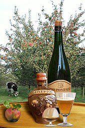
- Pays d'Auge is regarded as the model picture of Normandy: cattle breeding, stud farms, half-timbered houses and apple orchards - cheese, cider and calvados. In the East; continues in the Orne department.
- Bessin and Cotentin, marshland with heaths and moors. In the north-west; continues in the department of Manche.
places

- Caen is the prefecture (administrative seat) of the department.
- Aunay-sur-Odon
- Bayeux
- Deauville, elegant seaside resort with a marina, horse racing track, casino, beach promenade, magnificent villas and hotels
- Hérouville-Saint-Clair
- Honfleur, picturesque town at the mouth of the Seine
- Lisieux
- Mondeville
- Ouistreham
- Vire
Landscapes

That in the border areas of the Armorican Massif (massive armoricain) and the Paris basin (bassin parisien) is characterized by its diversity. It is divided into several landscapes shaped by the oceanic climate.
The plateau du Calvados
in the north forms the coastal strip. It gave the department its name. The main source of income is tourism, both on the one in the west Landing Coast than in particular in the eastern coastline, which can be reached more quickly from Paris, at Cabourg, Dauville, Trouville and Honfleur.
The Norman bocage landscape
in the southwest, in the vicinity of VireDue to the higher elevation and the more humid climate, it is used more for cattle breeding than for agriculture;
The Bessin
in the northeast, near Bayeux, forms a landscape almost exclusively characterized by meadows and pastures;
The Caen Plain
in the heart of the department is, due to the calcareous soil, growing area of grain and sugar beet;
The Pays d'Auge
in the east, the picture that comes closest to the cliché of Normandy is that of the cows on gently undulating, lush green pastures planted with apple trees. The most important sources of income are the production of dairy products, cider and calvados.
The coast of the Pays d'Auge is called Cote Fleurie referred to, here are the places Honfleur, Trouville-sur-Mer, Deauville, Houlgate and Cabourg.
Other goals
The landing coast
The code names used when the Allies landed for the various coastal sections have established themselves as place and beach names and can also be found on maps or signposts. Utah Beach lies in the west, across the Vire estuary and thus in the département Some (look there). On the Calvados coast, starting from the west:
- Omaha Beach and Pointe du Hoc: This is where the bitterest fighting took place. Tourist centers are at the American War Cemetery Colleville-sur-Mer and the bay below and Pointe du Hoc Grandcamp Maisy.
- Gold Beach and Longues: The actual Gold Beach is a flat sandy beach, to the west of it Longues-sur-Mer with its well-preserved artillery position on the cliff.
- Juno Beach: Shallow sandy beach.
- Sword Beach: Beach section on both sides of the Orne estuary.
background
The longest section of the 100 km long coastline, on which the Allies landed on June 6, 1944 (D-Day), is in the Calvados department. Numerous relics from the Second World War as well as museums and monuments can be visited along the entire coast up to approx. 10 km inland.
Even without this great historical significance, the coast of Calvados would definitely be worth a visit. As early as the end of the 19th century, the sandy beaches were increasingly attracting summer visitors from inland cities. Many of the old beach villas were badly damaged by the occupation and fighting, but many were restored after the war. The up to 50 m high chalk cliffs, some of which rise vertically from the sea, and the bays in between contribute to the special character of the coast.
The interior is less spectacular and more tranquil. But also the so-called. Bocage-Landscape with smaller fields, which are separated from each other by hedgerows and streams, has its own charm. Agricultural areas and wetlands alternate. Calvados is known for its cider (apple wine) and of course the apple brandy that gives it its name.
language
getting there
By plane
The department has two airports:
- the Aéroport de Caen-Carpiquet at Caen is made up of line machines Lyon and Brighton approached. Example: The flight Munich - Caen and back with a change in Lyon takes 3 1/2 hours and costs just under EUR 400.
- the Aéroport de Deauville Saint-Gatien, in the east of the department at the mouth of the Seine, receives scheduled flights from London-City and charter flights.
A landing on the one in the neighboring department Seine-Maritime located airport Le Havrethat flights out Amsterdam, London and Brighton receives, or the airport Rennes in Brittany is due to the complicated transfer procedures (no direct flights from Germany, bus travel from the airport to the train station, none direct Rail connection from Le Havre) may be less interesting than booking a direct flight to Paris with train connection to Caen or Viré (see Arrival by train).
By train
There are train connections from the train stations of origin
- Paris St-Lazare: IC trains to Caen approximately every hour (journey time approx. Two hours), seven IC trains a day to Lisieux, three direct IC trains a day to Trouville-Deauville (a good two hours, otherwise with a change in Lisieux, which does not take much longer )
- Paris Montparnasse: IC to Vire five times a day, travel time approx. 2½ hours
- Rouen: TER seven times a day to Lisieux (1:10 hours), Mézidon (1½ hours) and Caen (1:45 hours)
- Le Havre Central Station: Travel time to Caen at least 2:40 hours with a change in Rouen
- Rennes Central Station: Travel time to Caen approx. 3 hours
There are also railway lines between Cherbourg and Caen and Le Mans and Caen.
By bus
Ouibus, the long-distance bus subsidiary of SNCF, offers buses three times a day from La Défense, a western suburb of Paris, to Caen. The journey takes just under three hours and costs € 12, if you book early you can even get the saver price of € 9.
In the street
The journey takes place by car
- from the west from Paris, Porte de Saint-Cloud via the A 13 in the direction of Rouen via Pont-Audemer, Pont l'Evêque to Caen (232 km)
- from the north from Liège via the A 29 via Amiens to Honfleur or Caen (534 km)
- from the south from Le Mans via the A 28 and the A 88 via Alençon to Falaise or Caen (164 km)
- from Brittany from Rennes via the A 84 to Caen (190 km)
By boat
Ferry port with connections from Portsmouth is Ouistreham. It drives Brittany Ferries with standard ferries (6 hours travel time, EUR 400 for a return trip by car and 2 passengers) and High speed Ferries (3 1/2 hours, 420 EUR). Strong price fluctuations depending on the travel time.
By bicycle
The European long-distance cycle route runs through the department EuroVelo 4, which leads from Germany, Belgium and the Netherlands, through Deauville, Cabourg, Ouistreham and along the D-Day landing coast to Mont-Saint-Michel and Brittany. You can also take the French cycle route V40 to Calvados, which runs from Angers on the Loire via Laval and Flers to Caen and Ouistreham.
mobility
Tourist Attractions
Churches and monasteries

Under the Sacred buildings are - in addition to numerous interesting parish churches and chapels - the two for Abbaye aux Hommes (Men's abbey) and to Abbaye des Dames (Women's abbey) belonging Romanesque churches, later vaulted in Gothic style Saint-Etienne and Sainte-Trinité in Caen of which the former was founded in 1064 by William, Duke of Normandy (1035-1085) the later conqueror, the second in 1062 by his wife. The two churches house their tombs.
Also worth mentioning are the Romanesque in their basic structure, but heavily Gothicized and adapted several times to the zeitgeist Notre-Dame de Bayeux Cathedral (11th / 12th century and 15th century) and the Romanesque / Gothic one Saint-Pierre de Lisieux Cathedral (1170-1250, tower 16th century). In Lisieux, the second largest pilgrimage site in France, the Saint Therese consecrated by the child of Jesus basilica annually around one and a half million pilgrims and visitors.
Castles and Palaces
- Castle of Duke Wilhelm I.. From 1066 as William the Conqueror, King of England, in Caen. The castle houses a museum on the history of Normandy and an art museum.
- Falaise Castle
- Bonneville-sur-Touques castle ruins
- Saint-Germain-de-Livet Castle. 15./16. Century, near Lisieux, located on an island romantic castle from the transition period from the Middle Ages to the Renaissance.
- Fervarques Castle and Park
- Fontaine-Henry Castle. 16th century
- Balleroy Castle. Classicist-Baroque castle (17th century) with an English landscape garden.
additional

- Bayeux Tapestry, over 68 meters long and 52 centimeters high, embroidered tapestry from the 11th century depicting the conquest of England by the Normans.
- Beuvron-en-Auge: one of the most beautiful villages in France with historic half-timbered houses

- The Remembering the events of the Second World War, especially D-Day, are kept alive by relics from the Second World War, numerous memorials, monuments and museums and, last but not least, by a number of military cemeteries.
Selection of historically significant points on the D-Day landing coast from west to east:- German military cemetery - The German military cemetery of Normandy is located near the town of La Cambe. All German fallen soldiers were reburied here after the war. Extremely impressive, the age of the dead can often be seen on simple metal plates, it couldn't be worse, there are 22,221 dead buried there.
- Pointe-du-Hoc - A very popular excursion destination, which can be seen almost unchanged as it was left behind after the fighting and bombing. A visit there can be combined with the La Cambe cemetery. If you are not afraid of it, you can visit this place in bad weather to get a hint of the feeling the people felt back then.
- Omaha Beach was the most extensive landing section with a length of more than ten kilometers and was again divided into eight landing zones, which were designated from west to east as Charlie, Dog Green, Dog White, Dog Red, Easy Green, Easy Red, Fox Green and Fox Red. Easy Red was the longest section at around 2.2 km. Omaha extended from the mouth of the Vire in the west at Vierville-sur-Mer to the small fishing port of Port-en-Bessin.
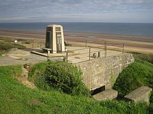
- American war cemetery - Above Omaha Beach and WN62 is the largest American war cemetery in Normandy. The graves of around 9400 American soldiers are located here. At the same time, it is a memorial from 1560, until today, missing soldiers. This cemetery became famous from the opening scenes of the war drama "Saving Private Ryan", in which a war veteran visits the grave of his former captain.
- Resistance nest 62 (WN62) - A short walk further below the town of Collevile-sur-Mer, you can still see the defensive positions of the German soldiers. The stretch of beach around WN62 was one of the most competitive landing zones on D-Day 1944.
- Port-en-Bessin - A small contested port that was used to supply the landing units with fuel after the conquest. It was secured from positions on both sides of the harbor basin. One of the two positions is very difficult to find as it is not signposted.
- Longues-sur-Mer - Probably the best preserved coastal battery is here. The way is well signposted.
- Arromanches - Remnants in the water are reminiscent of the artificial harbor (Harbor B) that was built here. A very great museum illustrates the construction of this amazing structure very clearly. Admission: 6.50 euros
activities
kitchen
nightlife

- Deauville Casino. The casino is one of the largest casinos in France and all of Europe. International poker or bridge tournaments take place here regularly. The complex also includes a cinema and a night club.
security
climate
trips
- Reserve Naturelle de l'Estuaire de la Seine
literature
- Charles-Henri de Bossieu, Yves Garnier, Philippe Lacrouts (Ed.): Atlas départemental de la France. Larousse, 2004, ISBN 2-03-505448-6 ; 288 pages.
Web links
- Comité Départemental du Tourisme du Calvados - official website (German)