 | ||
| Philippi | ||
| region | East Macedonia and Thrace | |
|---|---|---|
| Residents | unknown | |
| no value for residents on Wikidata: | ||
| height | unknown | |
| no value for height on Wikidata: | ||
| no tourist info on Wikidata: | ||
| location | ||
| ||

Philippi is an archaeological site in Greece. It has been part of the UNESCO world cultural heritage.
background
The archaeological site of 1 Philippi![]()
![]()
![]()
![]() is one of the most important archaeological sites in northern Greece. It includes characteristic monuments of the Hellenistic, Roman and late ancient times.
is one of the most important archaeological sites in northern Greece. It includes characteristic monuments of the Hellenistic, Roman and late ancient times.

Their story began in 360/359 BC. When colonists from the island of Thasos founded the city under the name of Krenides. In 356 BC The inhabitants sought protection and support from King Philip II of Macedonia, as the city was threatened by the Thakers. Philipp had already recognized the economic and strategic potential of the city. So he captured and fortified it and named it Philippi after himself.
After the Battle of Philippi in 42 BC. Roman veterans settled in Philippi, which became a colony in the Roman sense of the word. The vibrant Hellenistic city of Philip II, whose walls and gates, the theater and some tombs can still be seen, was supplemented by Roman buildings such as the forum and a monumental terrace with temples in the north. Your location at the Via Egnatia, an important Roman highway, encouraged its further development.
Of particular importance for the later history of Philippi was the year 49 or 50, when the apostle Paul visited the city and built the first Christian church in Europe there and also carried out the first Christian baptism. This made Philippi a nucleus of Christianity in Europe. This was also reflected in the construction of several large basilicas in late antiquity. Therefore, there is also a lot of religious tourism in Philippi.
The decline began with the so-called "Justinian Plague" (547 AD) and an earthquake (around 619 AD), by which the city was almost completely destroyed and never returned to its former importance. In Byzantine times, around 850 AD, wars broke out with the Bulgarians for the city, which Byzantium won. As a result, the city was fortified in the 10-11 century. After a brief occupation by the Franks after the Fourth Crusade and the conquest of Constantinople in 1204, the city was conquered by the Serbs. Eventually, at an unknown point in time, Philippi was completely abandoned. The Via Egnatia At this point in time, it had clearly lost its importance as a trade route in favor of sea trade (especially through the northern Italian cities). Many places along the Via Egnatia were thus deprived of their economic basis. In addition, the area was often exposed to Slavic raids due to the lack of a sufficiently strong military protective power. During the time of the Turkish occupation, the Turks used it as a quarry.
Systematic archaeological excavations on the Philippi site began in 1914 under the direction of the École française d’Athènes. After the Second World War, the excavations were resumed by the Greek Archaeological Society. Today the archaeological excavations are being continued under the direction of the Greek Ministry of Culture, the University of Thessaloniki and the École française d’Athènes.
getting there
The journey to Philippi takes place via Kavala (15 km) or drama (25 km). All connections are described there. The buses to Philippi run regularly from the bus station in Kavala or Drama. The junction from the main road Kavala-Drama to Philippi is well signposted. One reaches a large parking lot, which surrounds a small park and is also suitable for mobile homes.
Tourist Attractions


.jpg/400px-Philippi_(7273015222).jpg)


The restaurant in the park in front of the entrance to the archaeological site with plenty of outdoor seating under trees is the best place to relax after a tour of the ancient site. Since there is hardly any shade in Philippi, it can get quite warm when visiting in midsummer. The old Via Egnatia and later, now disused federal road divides the area into two parts. The upper part is dominated by the ancient theater, the lower by the remains of the city.
The entrance leads directly to:
- 2 theatre.


 in the Wikidata database") (No. 2 on the map). It was probably built by King Philip II around the middle of the 4th century BC. Built in the 2nd and 3rd centuries AD and extensively redesigned and supplemented by the Romans in the 2nd and 3rd centuries AD, so that the function of the theater could meet the needs of the performances at that time. It was partially restored so that it will be used again this summer for theater and music performances. The view from the stands over the ruined city and the mountain Pangeo in the background is fantastic.
(No. 2 on the map). It was probably built by King Philip II around the middle of the 4th century BC. Built in the 2nd and 3rd centuries AD and extensively redesigned and supplemented by the Romans in the 2nd and 3rd centuries AD, so that the function of the theater could meet the needs of the performances at that time. It was partially restored so that it will be used again this summer for theater and music performances. The view from the stands over the ruined city and the mountain Pangeo in the background is fantastic.
.jpg/320px-Ancient_Theatre,_built_by_Philip_II_in_the_4th_century_BC_and_later_reconstructed_by_the_Romans,_Philippi_(7272297822).jpg)
About 150 m further on you can see the remains of a basilica, of which only the foundation stones remain:
- 3 Basilica a.(No. 6 on the map). Foundation stones of a large, three-aisled basilica (130x50 m) with a transept on the east side, a square atrium and gallery over the aisles and the narthex (narrow, single-storey vestibule at the main entrance). Fragments of the luxurious floor and parts of the ambo (pulpit) have been preserved in the central aisle. The frescoes are particularly impressive. Dated to the end of the 5th century AD

If you stay above the road, after another 150 m, past the remains of Basilica C (No. 17), you will reach:
- 4 Basilica C.A three-aisled basilica with remains of luxurious marble inlay on the floor. Dated to the 6th century.
- 5 Archaeological Museum.(No. 18 on the map). The museum mainly contains various archaeological finds from the area of the city of Philippi and the surrounding area.
,_Philippi.jpg/320px-Basilica_C_(Basilica_at_the_Museum),_Philippi.jpg)
.jpg/320px-Philippi_Museum_(7416507606).jpg)
In front of the entrance area of the museum, the path goes up to the Acropolis. Especially in summer, the ascent is a bit difficult because of the incline and the lack of shade, but it is still recommended.
- 6 acropolis. From the Acropolis with its tower from the late Byzantine period you have a wonderful view of Philippi and the surrounding landscape. This makes the somewhat arduous ascent definitely worthwhile.
If you leave the upper part of the excavation site next to Basilica C, you pass an ancient water cistern, which was interpreted as the prison of the Apostle Paul (No. 7), crosses it Via Egnatia and comes to the large, central market (Greek agora, Latin forum), behind which the basilica B is located.
- 7 Agora (forum). (No. 8 9 on the map). The forum was developed into the administrative center of Philippi in Roman times. It is a complex of public buildings arranged around a central open space. The most impressive buildings are the Northeast Temple and the North West Temple.
- 8 Basilica B.(No. 10 on the map) Three-aisled basilica dates to the middle of the 6th century AD. It has a narthex and ancillary buildings in the north and south (phiale, sacristy). The almost square central aisle was covered with a vault supported by large pillars. A second vault covered the bema (closed space in Orthodox churches). The basilica B covers most of the previous one Palaestra (No. 11), an educational establishment where both physical and spiritual education took place. The palaestra consisted of a central courtyard, rooms arranged around the outside and a small amphitheater.
- 9 Roman villa. These ruins lie outside the fenced-in excavation area and are freely accessible.
- 10 basilica. The ruins are located in Krinides, 500m from the parking lot.

- 11 Philippi Battlefields (Μάχη των Φιλίππων).In the double battle at Philippi west of Philippi in October / November 42 BC they were victorious. The Roman triumvirs Mark Antony and Octavian (later Emperor Augustus) over the followers of the republic, Mark Junius Brutus and Gaius Cassius Longinus, who were among the leaders in the assassination attempt on Gaius Julius Caesar. You can no longer see the battles in the fields. Only the 2 hills, each about 500 m from the mud bath, were part of the fortifications of Cassius' army and are still visible today. On the larger, northern hill you can still see the remains of the fortifications and have a beautiful view of Philippi and the second hill and the former marshland. There is no path up the hill, so you have to go cross-country. However, the ascent is not strenuous and the view is worth the effort. In the immediate vicinity of the hills is the Lasponera mud bath, where you can park well and also find refreshment in the restaurant. It is well suited as a starting point to visit the northern hill. The southern hill offers nothing to see and is not worth the climb.

kitchen
In addition to the restaurant in the park at the excavation site, there are several restaurants in the village of Krenides within walking distance or in the village of Lydia, 3 km away. However, it is particularly recommended to continue driving about 10 km towards Drama to 1 Apo Kefalari. The village is located at the foot of a mountain and is known for its romantic cafes and restaurants specializing in trout, which line up along a stream. Even on hot summer evenings, it is relatively cool here. From Kato Kefalaria it is 2 km away 2 Piges, whose visit is also recommended. There is an excursion restaurant on a small lake.
accommodation
There are other highly recommended hotels in 15 km away Kavala
Practical advice
- During the summer, it is advisable to take a headgear to protect against the intense sun when visiting, as there is hardly any shade on the excavation site.
- In the summer, performances of ancient dramas or music events take place in the ancient theater. You should definitely take seat cushions with you, otherwise sitting on the rows of stones for long periods of time can be a torture.
trips
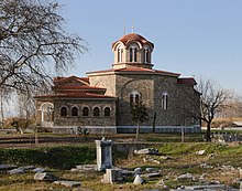
- 12 Lydia (Λυδία Καβάλας).A visit to Philippi also includes a visit to Lydia, about 1 km away. At the entrance to Lydia there is a remarkable church and a cross-shaped baptismal font in a stream, where adult baptisms are carried out. Many Greeks have their children baptized in the chapel because of the special importance of the place for Christianity. According to local legend, the apostle Paul performed the first baptism on European soil, that of the wealthy Jewish trader Lydia, in the stream that flows next to the chapel.

- 13 Lasponera. A few kilometers from Lydia is Lasponera, a healing mud bath that helps relieve joint and back pain. You only need a towel to visit the bath, as you bathe naked in the mud, men and women separated. Even if you are in good health, it is worth a visit! Since it is an open-air facility, the mud baths are only open from June to October. There is also a therapeutic spring to enjoy in a historic post-Byzantine bath and massage therapists on site.

- 14 Gravestone of Gaius Vibius. This Roman tombstone of Gaius Vibius is a 4 m high marble monolith from the 1st century AD and is located near the village of Krenides. Two of its four sides bear an inscription that refers to the career of the Roman officer Caius Vibius Quartus. The damage to the monument is said to have been a measure to stop the old habit of pregnant women in the area of secretly rubbing against the marble corners in an "immoral" way, believing they would only have male children. So the corners of the memorial were removed to put an end to sin (sinful memorial).

- 15 Dikili Tash.The archaeological site of Dikili Tash is a prehistoric settlement from the Neolithic Age (6400-4000 BC) and the Bronze Age (3000-1100 BC). There are also individual remains from the Hellenistic and Roman times and a Byzantine tower. There isn't really much to see, so this site is of more interest to archaeologists. It is noteworthy that the oldest evidence of winemaking in Europe has been found in this settlement.

- Kavala - Most beautiful stand in Northern Greece with harbor, castle, aquaduct, old town
- drama - Provincial town with beautiful surroundings
- Pangeo - Mountain massif with very beautiful mountain villages, monasteries
- Nestos - Nature reserve of particular scenic beauty.