| Guanacaste province | |
 | |
Location 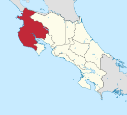 | |
Coat of arms and flag  | |
| State | Costa Rica |
|---|---|
| Capital | Liberia |
| Surface | 10,141 km² |
| Inhabitants | 326.953 (2011 census) |
Guanacaste province is a region of the Costa Rica bordering the Guatemala.
To know
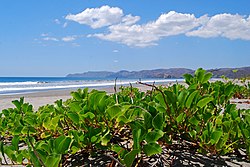
Guanacaste is roughly a plain with a drier climate than the rest of the country, which has favored livestock rather than plantations. Capital of Guanacaste is Liberia, a city with an international airport where tourists of nationalities are unloaded in droves American/Canadian and mostly young, eager to reach the beaches of Nicoya where they can devote themselves to their favorite sports. On the Pacific side there are two peninsulas of similar shape: the Nicoya Peninsula in the northern section and the smaller one of Dare in the southern section.
Territories and tourist destinations
Urban centers
- 1 Cañas - Located 48 km south of Liberia on the Pan-American carretera, Cañas is a city of about 30,000 inhabitants dedicated to cattle breeding. Its tourist interest is limited to its church (Iglesia de Cañas) and the colorful mosaics of the interior made by a local painter. From Cañas the carretera nº 142 leads to the lake and to the Arenal volcano, one of the most touristic areas of the Costa Rica. Relatively close at hand is also Monteverde and the reserve of the same name which covers a dense vegetation on the Tilaran mountains.
- 2 La Cruz - 20 km from the border crossing, La Cruz it is a village among hilly landscapes but without any interest. However, it has some hotels for those who, tired of the journey, would like to stop. It should be noted, however, that in the nearby Salinas bay there is playa Coyotera with a hotel, the Ecoplaya which can be a base for visiting the Santa Rosa National Park.
- 3 Liberia - Capital of the province of Guanacaste, Liberia it is a city with a colonial air but of limited tourist interest. However, being equipped with hotels, Liberia can form the basis for excursions to the nearby Volcán Rincón de la Vieja National Park.
- 4 Nicoya
- 5 Sámara - District of the canton of Nicoya.
- 6 Tamarind
- 7 Tilarán - Capital of the canton of the same name.
Other destinations
- 1 Bahía Salinas - The northernmost gulf, divided between Costa Rica is Nicaragua. Inside there are tiny islands, the Murciélago archipelago and the Bolaños island, wildlife reserves that fall under the jurisdiction of the Santa Rosa park. Due to strong winds and low water temperatures (maximum 15 ° during the dry season), the coast of Bahía Salinas is almost exclusively frequented by surfers while Puerto Soley offers opportunities for fishing enthusiasts, even with hooks.
- 2 Golfo de Papagayo - In the small bay that opens into the largest Golfo de Papagayo, limited to the north by the peninsula of Santa Elena, are the beaches of Playa Hermosa, Playa Panamá and Playas del Coco, all three with significant tourist infrastructures favored in this by the proximity to the international airport of Liberia with frequent flights from US and Canadian cities. The bay of Culebra is deep and sheltered from the rushing winds of the Pacific so its waters are suitable for bathing. The largest and most luxurious structures are located in the narrow peninsula of Papagayo which closes the bay to the north. Thus the small and pretty Playa Nacascolo is the place of the luxurious Four Seasons. The rooms of these large hotels are generally booked by tour operators from all over the world for their customers, therefore there is little space left for those who travel individually but since the beaches of the Costa Rica are public you can always drop by.
- 3 Rincón de la Vieja National Park (Parque Nacional Rincón de la Vieja) - The park contains the homonymous volcano, one of the 5 still active in Costa Rica.
- 4 Tenorio Volcano National Park (Parque Nacional Volcán Tenorio)
- 5 Santa Rosa National Park (Parque Nacional Santa Rosa) - The park covers almost the entire peninsula of Santa Elena where there are beaches not yet targeted by tour operators. The park was in fact set up to protect the sea turtle that arrives on the coasts to lay its eggs. Among the beaches Playa Naranjo is the most accessible while the others (Playa Nancite, Playa Colorada and Playa Blanca) can only be reached via dirt roads. You will not find accommodation of any kind but only a campsite in Nancite that requires reservations. If you love comfort, the only hotel in the area is the ecoplaya.
How to get
By plane
- 1 Daniel Oduber International Airport (IATA: LIR). Located near the capital, flights land there, mostly seasonal, from various North American cities. As of 2020, the only airlines operating flights fromEurope they were there KLM from Amsterdam and the TUI Airways from London–Gatwick.


By car
- 2 Peñas Blancas - Border crossing with Nicaragua on the Pan-American road.
How to get around
What see
Itineraries
Assuming you enter the country from the pass of Peñas Blancas, and to enter the country, we will meet on the Panamerica route and its branches the territories and places of tourist interest listed below:
- Peñas Blancas - Border crossing with Nicaragua.
- La Cruz - 20 km from the border crossing.
- Santa Rosa National Park —
- Liberia —
- Bahía de Culebra —
- Cañas - 48 km south of Liberia.
What to do

- 1 Playas del Coco - The most famous of the beaches on the Gulf of Papagayo, in continuous development thanks to its proximity to the Daniel Oduber International Airport (20 min. By bus).
At the table
Safety
Other projects
 Wikipedia contains an entry concerning Guanacaste province
 Commons contains images or other files on Guanacaste province