 Palm gardens in the north of el-Qaṣr | ||
| Qaṣr el-Bāwīṭī · قصر الباويطي | ||
| Governorate | Gīza | |
|---|---|---|
| Residents | 8.051 (2006) | |
| no tourist info on Wikidata: | ||
| location | ||
| ||

Qasr el-Bawiti (Arabic:قصر الباويطي, Qaṣr al-Bāwīṭī) or short el-Qasr (Arabic:القصر, al-Qaṣr, „the fortress“) Was once an independent village and now forms a district in the west of el-Bāwīṭī. El-Qasr has largely retained its village-like character. In its west there are archaeological evidence from the ancient Egyptian late period and the Roman period. In the northeast of the village, on the edge of the palm gardens, there is the 'Ain el-Bishmu spring, which is one of the most important springs in the entire valley.
background
The sink el-Baḥrīya experienced a significant boom in the 26th ancient Egyptian dynasty and was an important production location for dates, olives, wine and grain. At least since that time el-Qaṣr has also existed[1] and is the main place of the valley, especially in Greco-Roman times.
The existence of a settlement in the area of el-Qaṣr since Late Egyptian Period documents a single-line ceiling inscription in a local chapel in which the king Apries from the 26th dynasty is called.[2] In addition, relief stones from a temple of Hercules were found in el-Qaṣr, but they could have been dragged here.[3]
Also in roman time the village was inhabited, as evidenced by the large triumphal arch, which was still largely preserved at the beginning of the 19th century.
In the 1930s and 1940s, ten houses were demolished in el-Qaṣr Ostraka labeled in Arabic but undated (Shards of stone) found, which prove a settlement by Copts and Arabs.[4] These documents were written by Adolf Grohmann (1887–1977) in the 9th century (3rd century AH) and from Ahmed Fakhry (1905–1973) dated to the (early) Mameluke period (13th / 14th centuries). A note of obligation (promissory note) might be the most interesting document as it is an early legal document. Further documents are a lease receipt and a letter from a Yaʿqūb to a Girga, son of Yūsuf. Most of the people mentioned have a Coptic (Christian) background.
The modern one Surname of the (former) village El-Qaṣr is likely to be derived from the aforementioned Roman triumphal arch, which was located in the north of the village. The ancient name of the place is unknown.
For a long time it was suspected that it was in the Roman State Handbook Notitia dignitatum (Not.dign.or. 28,22) as the quarters of a unit, an Armenian cavalry squadron (Ala secunda Armeniorum), designated castrum Psôbthis (Greek Καστρον Ψώβθεος)[5] could have been here in el-Qaṣr.[6] In the meantime they have moved away from it and localized Psôbthis in the Nile Valley near Oxyrhynchus, today's el-Bahnasā.[7]
In 1980, 2,000 people lived here in around 450 households, who farmed 300 faddān (126 hectares) of land with 33,000 date palms. The water was drawn from seven "Roman" (that is, old) and three modern deep wells.[8] In 2006 there were 8,051 inhabitants.[9]
getting there
Information on how to get there is in the article el-Bāwīṭī.
mobility
The main roads are paved, but some of them are only blocked roads. It's easy to get around on foot, by bike, motorcycle or car. In the case of the use of cars, or better off-road vehicles, one should take into account that some alleys are sometimes quite narrow.
Tourist Attractions
Source 'Ain el-Bishmu
Even if the place is not being upgraded by a modern pumping station, so is the old spring 1 'Ain el-Bishmu(28 ° 21 ′ 10 ″ N.28 ° 51 '49 "E), also Ain / Ayn el-Bishmu, Arabic:عين البشمو, ʿAyn al-Bishmu, „Bishmu source“, One of the most attractive places on site. This spring has been one of the most important springs in the El-Baḥrīya basin since ancient times. You can tell the age when the locals speak of a "Roman" spring.

The source 'Ain el-Bischmu rises from a rock massif, which is located in the south of the source. The water flows north and irrigates the palm gardens in the north of the city.


Walk through the village
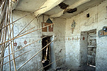
A stroll through el-Qasr is worthwhile. A number of old adobe houses are still preserved, even if they are no longer all inhabited. The rows of houses are interrupted by gardens with palm trees and fruit trees. In the case of dilapidated buildings, one can get an impression of the interior of the houses.


mosque
In the southeast of el-Qaṣr is the Libyan or 2 Sanusi mosque(28 ° 21 ′ 10 ″ N.28 ° 51 ′ 45 ″ E), Arabic:جامع زاوية السنوسية, Ǧāmiʿ Zāwiya as-Sanūsīya, „Sanūsi mosque". Two mosques stand side by side: the modern one in the south and the historic one in the north. The old mosque was built from adobe bricks around 1900 by the supporters of the Sanusi brotherhood. The prayer room is divided by pillars in the form of an arcade that support the roof made of palm trunks. There is a wooden pulpit on the wall (Minbar). To the east of the mosque is its minaret, the lower half of which is roughly square, while the upper part is round and tapers towards the top. In the upper part there is also a surrounding wooden gallery with a railing.


Sheikh tombs
There are also some graves of important personalities in el-Qa Persönr. They were also built from mud bricks. The lower part has a roughly square floor plan, while the dome, which tapers to the top, is round. They only have one entrance, but no windows. The dome has numerous round openings for ventilation and lighting.
The important graves include:
- the 3 Tomb of the Sheikh Ḥamād(28 ° 21 '7 "N.28 ° 51 ′ 20 ″ E), Arabic:مقام الشيخ حماد, Maqām al-Sheikh Ḥamād, west of the triumphal arch,
- the 4 Sheikh el-Badawī's tomb(28 ° 21 ′ 21 ″ N.28 ° 51 ′ 0 ″ E), Arabic:مقام الشيخ البدوي, Maqam al-Sheikh al-Badawī, near 'Ain el-Muftilla.

Roman triumphal arch
The most important testimony from Roman times is that 5 Triumphal arch(28 ° 21 '18 "N.28 ° 51 ′ 31 ″ E), Arabic:القصر القديم الروماني, al-Qaṣr al-qadīm ar-rūmānī, of which only the several meters high platform in the north of el-Qaṣr is preserved today.

Nothing can be made out of its former splendor today. It is quite complete from the first half of the 19th century Frédéric Cailliaud (1787-1869) and George Alexander Hoskins (1802–1863) seen and drawn[10] or described[11] been.


Hoskins described that the triumphal arch was on a 128 feet (43 meters) long and 33 feet (10 meters) high platform, which was closed at the top with a kind of hollow. The triumphal arch opened to the north and was 25 meters long. There was a chapel with a niche on either side of the arch. The chapels and niches were framed with pilasters (half pillars) or columns. As Rohlfs described, by 1874 the decline was already well advanced.[12]
Temple of Bes
Only discovered in 1988 6 Temple of Bes(28 ° 20 ′ 52 ″ N.28 ° 51 ′ 30 ″ E) is fenced in, and you are not allowed to enter the area. Nevertheless, its components can also be perceived from the outside. The Ptolemaic (Greek) temple for the god Bes was used until the 4th century AD and destroyed at the beginning of the Christian era. The adobe temple, which is still up to one meter in length, is about 20 × 14 meters in size, stands on a limestone foundation and faces north to south. A long driveway, perhaps lined with sphinxes, led to the entrance to the north. The temple consists of a wide transverse hall, which was used for the faithful, and behind it of another nine rooms, which were used as private rooms for the temple staff and as a sanctuary. The subdivision of the nine rooms was probably not made until Roman times. To the east of the temple there is a water shaft, the water of which may have been used for healing purposes. Until its discovery in 1988, the area of this temple was used as a clay pit.

The excavations under Ashry Shaker found copper vessels for ceremonial purposes in the transverse hall - two copper bowls decorated with plants and a copper vessel with cow-shaped legs (perhaps as a censer) - a bowl made of red ceramic, a faience ushabti, a cat amulet, a Horus amulet and a board game came to light. The most important find, however, was a 1.2 meter high figure of the god Bes, which still had remains of the original painting and represented the deity worshiped here in the temple. Around 2000 this statue was still part of the mummy exhibition in the warehouse building in el-Bawiti. Today she is in Cairo Egyptian Museum magazined.


Qārat al-Farārgī
In the south of the village is his cemetery. Between this cemetery and the power station there is a large hill called the 7 Qārat al-Farārgī(28 ° 20 '49 "N.28 ° 51 ′ 21 ″ E), Arabic:قارة الفرارجِي, Qārat al-Farārǧī, „Hill of the Chicken Dealers“, Called by the locals.

Little is known of the local hill, and even the locals think that there is nothing to see here. On its northeast side, however, there are structures that suggest that this hill could also have been used for burials.
The hill is famous as the namesake of Ibis galleries, which are not here, but in the north of the cemetery of el-Bawiti. At the time of the discovery of the Ibis Galleries, large parts of it were undeveloped and the hill about 1 kilometer away was the only visible and name-bearing location far and wide.
More Attractions
In the east of el-Qaṣr there are important archaeological sites that were certainly related to el-Qasr. On the one hand, there are the chapels open to tourists ʿAin el-Muftillā, and the Roman fortress Qārat eṭ-Ṭūb.
kitchen
There are some restaurants in el-Bāwīṭī.
accommodation
Some hotels are located in the 'Ain el-Bishmu area. Their description can be found in the article el-Bāwīṭī.
trips
A visit to el-Qaṣr can, for example, be combined with a visit to the ancient sites in the vicinity of el-Bawiti. These are the "museum" in el-Bāwīṭī, the burial ground of Qārat Qaṣr Salīm, ʿAin el-Muftillā, Qārat Ḥilwa and the Alexander Temple ʿAin et-Tibnīya. The most comfortable excursion is with an all-terrain vehicle or by bike. But you can also walk.
literature
- Generally
- : The oases of Egypt. Vol. II: Bahrīyah and Farafra Oases. Cairo: The American Univ. in Cairo Pr., 1974, ISBN 978-9774247323 , Pp. 78 f., 89-92 (English).
- Roman wall arch
- : Baḥria Oasis, vol. II. Cairo: Government Press, 1950, P. 83, fig. 68, plate LI.A.
- Temple of Bes
- : The Valley of the Golden Mummies: the newest and greatest archaeological discovery of our days. Bern; Munich; Vienna: joke, 2000, ISBN 978-3502153009 , Pp. 168-173.
Individual evidence
- ↑The near at Qārat eṭ-Ṭūb The graves found date back to the 13th to 18th ancient Egyptian dynasties.
- ↑Fakhry, Ahmed: The April-time chapel in the Bahria oasis, in: Archive for Egyptian Archeology, Vol. 1 (1938), pp. 97-100, panel IX.
- ↑Wagner, Guy: Le temple d’Herakles Kallinikos et d’Ammon à Psôbthis-el Qasr, métropole de la petite oasis (Notes de voyage à l’oasis de Baharieh, January 18-25, 1974), Bulletin de l’Institut français d’archéologie orientale74: 23-27 (1974).
- ↑Grohmann, Adolf: Some Arabic ostraka and a marriage contract from the Baḥrīya oasis, in: Studi in onore di Aristide Calderini e Roberto Paribeni; 2: Studi di Papirologia e antichitá orientali, Milano: Casa ed. Ceschina, 1957, pp. 499–509. Fakhry, Ahmed, 1974, loc. cit., P. 71, footnote 2.
- ↑The name is derived from ancient Egyptian P3-sbtj for Temenos, a demarcated temple area, which would represent a reference to a sanctuary.
- ↑See e.g. Wagner, Guy: Les oasis d’Égypte: à l’époque grecque, romaine et byzantine d’après les documents grecs, Caire: Inst. Français d’archéologie orientale, 1987, (Bibliothèque d’étude; 100), p. 391.
- ↑Colin, Frédéric; Laisney, Damien; Marchand, Sylvie: Qaret el-Toub: un fort romain et une nécropole pharaonique. Prospection archéologique dans l’oasis de Baḥariya 1999, in: Bulletin de l’Institut français d’archéologie orientale (BIFAO), Vol. 100 (2000), pp. 145-192, especially pp. 158-163.
- ↑Bliss, Frank: Oasis life: the Egyptian oases of Bahriya and Farafra in the past and present, Bonn, 2006, p. 50.
- ↑Population according to the 2006 Egyptian census, Central Agency for Public Mobilization and Statistics, accessed December 16, 2014.
- ↑Cailliaud, Frédéric: Voyage a Méroé, au fleuve blanc, au-delà de Fâzoql dans le midi du Royaume de Sennâr, a Syouah et dans cinq autres oasis ... Atlas, Tome II, Paris: Imprimerie Royale, 1823, plates 37 (map), 38 (ʿAin Bischmū), 39 and 40 (triumphal arch).
- ↑Hoskins, George Alexander: Visit to the Great Oasis of the Libyan Desert: with an account, ancient and modern, of the oasis of Amun, and the other oases now under the dominion of the pasha of Egypt, London: Longman et al., 1837, pp. 225-227.
- ↑: Three months in the Libyan desert. Cassel: Fisherman, 1875, P. 220 f.Reprinted Cologne: Heinrich-Barth-Institut, 1996, ISBN 978-3-927688-10-0 .